Ireland day 0299. Sunday 24 July 2022- Weir
| Today’s summary | A short Sunday outing with the DWC while Val was at work. Exploring the brand-new Dodder Valley Park Greenway (opened April 2022) which goes right past – and affords good views of – the 778 year old Balrothery Weir. Another good outing on a lovely summer’s afternoon. | ||||
| Today’s weather | Bright, sunny and mostly dry, although there was a torrential downpour in Malahide just before I got back. Moderate south westerly wind. About 23C | ||||
 |
 |
||||
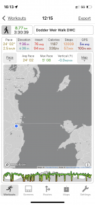
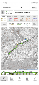
| Today’s overview location (The blue mark shows the location of our route) |
Close-up location (The green line shows where we walked) (Click button below to download GPX of today’s walk as recorded, or see interactive map at bottom with elevations corrected): Dodder Greenway and Balrothery Weir DWC |
||||
Commentary
I have been labouring under a misapprehension. I thought that there were just three rivers in Dublin – the Dodder, the Liffey and the Tolka. But that’s not right – there is actually a fourth – the Poddle. If I had thought about it a bit more carefully, I would probably have recalled that the Poddle river actually formed the southern boundary of the peninsula upon which the Vikings settled. The black pool in the Poddle near where it joined the Liffey being known as the Dubh Linn. But I thought that the Poddle had disappeared centuries ago and didn’t have a part to play in modern Dublin.
But in reality, the Poddle does still exist, it’s just that most of it has been built over or culverted, so it’s not easily visible. But it does flood from time to time, and can cause extensive damage when it does so. It flows into the Liffey at the Wellington Quay, on the south embankment, though I have never actually seen it.
The reason why it features in today’s blog is because of its historic connection to the Dodder Valley. The Poddle, for many years, was the main source of drinking water for Dublin. The problem was that as the city expanded, the flow wasn’t sufficient to provide the drinking water needs of the burgeoning population – a problem that was compounded by the industrial use of its waters in the many mills that sprang up on its banks.
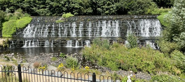
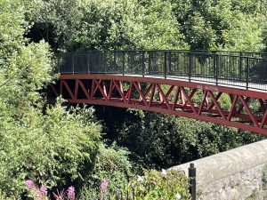
So a radical solution was devised. The River Dodder, which lies to the south of the Poddle would be partially dammed, and a new 3km / 2mi waterway would be built to draw water off from the new lagoon in the Poddle and to supplement the flow in the Poddle. The weir that was built in the Dodder to enable this to happen is situated just upstream of what is now the M50 motorway bridge. It’s known as the Balrothery or Firhouse weir.
What is particularly fascinating is that the water diversion scheme was devised in the early 13th century, so the weir you see today is an impressive 778 years old. (The water diversion scheme has fallen into disrepair, by the way – the 3km channel to the Poddle is silted up now – and only the weir remains. Dublin gets much of its drinking water from further up the Dodder valley, from the Bohernabreena reservoirs in the Glenasmole valley).
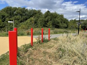
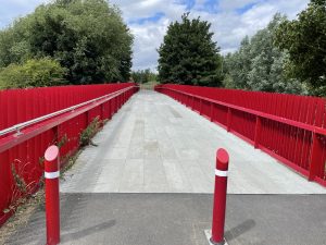
So the objective of our walk today was to explore the very new and the very old. The very old in the form of the weir, and the very new in the form of a greenway which runs through the Dodder Riverbank Park, and which only opened in April this year. I took the train and bus into Dublin (it’s cheaper than paying the toll on the motorway) and I met up with the rest of the walking club in the big car park near the Spawell roundabout. I’d been here in the winter, but on that occasion we were exploring Tymon Park, slightly to the north, because at that time this new greenway wasn’t finished.
The greenway turned out to be an outstanding creation. A beautifully engineered bit of pathway with lots of space for walkers and cyclists. The new section – or at least the bit we walked on from Spawell to Tallaght – is about 5km / 3mi long. We did an out-and-back walk to the end and then flipped on our heels to retrace our steps back at the end.
We had perfect weather today – lots of bright sunshine but a cool breeze to prevent overheating. So we proceeded at a leisurely pace, which gave plenty of time to catch up on all the news. We soon reached the weir, and paused at the point where a series of benches have been installed and which seem to have been built specifically to allow you to reflect on the scene – while enjoying your lunch. Which we did. And you can see the weir itself in the banner image at the top of this blog. It’s about 75m / 250ft long and 6m / 20ft high.
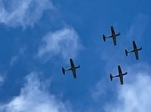
After lunch, the rest of the walk up to the end of the greenway and back was straightforward – the parkland is well maintained and attractive, with abundant banks of manicured wild flowers which seem to be very much in vogue – and beautifully so – in Ireland at the moment. All too soon, though, we were back at the start so we said our goodbyes and I jumped on the no 65 back into Dublin and then on to Malahide. It was a slightly slower journey back than normal today. Partly because of disruption caused by the Bray airshow further south, and partly because of fans leaving the All-Ireland Gaelic Football final at Croke Park (Kerry beat Galway 0-20 to 0-16, by the way).
So a really enjoyable day exploring the very newest and the very oldest of Dublin’s built infrastructure. I do hope that the new bridges and pathways of the Greenway which we saw today will be still in good shape long into the future, ready for our descendants to enjoy in another 778 years time.
Today’s photos (click to enlarge)
 |
 |
| At the start of the greenway near Spawell. Like all the greenways I’ve come across in Ireland, it’s well made with a properly engineered smooth tarmac or concrete surface. It’s perfect for cycling or wheelchairs, but hard on the feet if you have to walk any distance along it | Bridge just below the Balrothery weir. It was opened in 1995 but before this the only way across the Dodder at this point was a 130-year old lattice bridge – presumably falling into disrepair. But before that, if you wanted to cross you had to wade across the top of the weir – which guaranteed that you would get wet feet quite aside from being extremely hazardous. |
 |
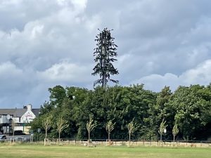 |
| No expense seems to have been spared in the construction of the greenway – this bridge, which must be 100m / 300ft long, looks like it could carry a motorway. But rather it just seems to be a little-used cycleway and walking route. Nevertheless, it’s an impressive piece of infrastructure and I hope it soon starts getting the usage that it deserves. | Mobile phone mast cunningly disguised as a tree. It’s so inconspicuous you would hardly know that it was there. |
 |
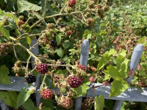 |
| The Irish Air Corps acrobatic stunt team heading down to the Bray Air Show this afternoon. The line-up for the even looked quite good, actually, and if we had been a bit better organised we might have tried to get down there to watch. Next year, maybe. | The blackberries which have been flowering so abundantly since early spring are starting to produce ripe fruit now. I actually tried a few – they were quite acid, but absolutely packed with flavour. they would make excellent bramble jelly |
 |
|
| Up at the western end of the greenway, near Tallaght, the Dodder cascades down another weir. This one – under the Old Bawn Road – is considerably less ancient than the Balrothery weir – but nevertheless quite impressive. Apparently otters can get up and down it, but fish can’t, so the breeding populations in the upper and lower Dodder are separate. I wonder if they will eventually evolve away from each other? | |
Interactive map
(Elevations corrected at GPS Visualizer: Assign DEM elevation data to coordinates )
Max elevation: 92 m
Min elevation: 57 m
Total climbing: 156 m
Total descent: -153 m
Total time: 03:30:39
You can read earlier and later days’ blogs below
Previous day’s blog
Next day’s blog
Ireland home page
 Save as PDF