Ireland day 0640. Friday 30 June 2023- Broadmeadow tides
| Today’s summary | Found out about tide times in the lagoon from the Broadmeadow cycleway consutation documents in the library. Then walked round the lagoon to Newbridge and kept dry feet | ||||
| Today’s weather | Dull grey and drizzly all day. Moderate to strong westerly wind. Appx 16C | ||||
 |
 |
||||
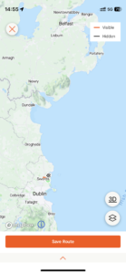
| Today’s overview location (The grey mark shows the location of my route) |
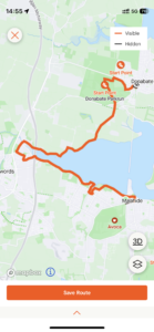
Close-up location (The orange line shows where I walked) (Click button below to download GPX of today’s walk as recorded, or see interactive map at bottom with elevations corrected): Broadmeadow tides walk via library |
||||
Commentary
(Summary blog only. Last full blog was Day 0368).
A fascinating day.
Val’s still away in the UK (I will be joining her tomorrow) so I had a relatively luxurious morning listening to podcasts and enjoying a cup of tea in bed. I eventually got up at about 9 and headed off to the library to return a book that I’ve been reading (very slowly) for the last four months.
While I was there I discovered that on public display were the consultation documents for the proposed Broadmeadow lagoon greenway (i.e. the path / cycleway over the lagoon alongside the railway embankment). Great excitement as I have been hoping that this would be moving forward for ages now. It’s good to see it is progressing at last though there is a lot of paperwork to be completed first, so I expect it will be quite a while yet before anything actually happens. I’ll have to look at it in more detail in the coming weeks but what caught my immediate attention were the tide charts in the Natura 2000 impact assessment document.
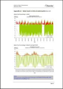
For the first time, I found a detailed analysis of inner lagoon and outer estuary tide levels and times related to phases of the moon, which I’d been searching for for a long time. You can see what some of the charts show, in the photos below. It’s fascinating.
But the upshot, as you can see from the explanation in the first two figures below, was that today water levels in the Broadmeadow lagoon were predicted to be very low. So I decided to take advantage of the dry foreshore to walk right round to Newbridge. And indeed I did manage to get round easily and dry-ly. And even better, halfway round, the summer cold that has been bothering me for the last couple of weeks, at last seemed to ease a bit.
So to celebrate all this excitement, I treated myself to a cup of coffee at the Newbridge visitor centre, before heading off to Donabate for the train back to Malahide. I’m looking forward to the day when I can walk back across the new bridge, rather than having to take the train. Well – maybe one day in 2050..
Today’s photos (click to enlarge)
 |
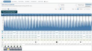 |
| From the Greenway consultation document (Natura 2000 study part 3). Showing the tides in the outer estuary (green) and inner lagoon (red). The lower chart is just an expansion of 2 months from the upper. I was pleased to note that the levels in the lagoon are indeed at their lowest during neap tides, which is what I had worked out. I hadn’t quite appreciated that of the two neap tides per lunar month, the one at the first quarter lunar phase is lower than at the third. And also that actually during the first quarter neap tides the lagoon drains continuously for about four days, even at high tide in the outer estuary. This is because the high tide in the outer estuary never gets high enough to get over the barrier under the railway causeway. Interestingly, subsequent charts in the consultation document show the water level in the lagoon will be permanently 10-20cm lower after the greenway is built, at each equivalent point in the tidal cycle. Presumably because the main drainage channel from the lagoon to the estuary will be deepened by about this amount, as a part of the new construction. But while construction is ongoing, water levels in neap tides will be about 20 cm higher than at present, because a temporary dam will be in place. (See <https://www.gov.ie/pdf/?file=https://assets.gov.ie/255460/e79726ae-d05c-499c-aef3-0dd3a22c7e16.pdf#page=null/td>) |
Tide chart for the Malahide estuary for today and the next 30 days. Right now, it is about 4 days after the first lunar quarter – so the lagoon will have been draining continuously and therefore at about the lowest level it ever gets. Which explains why I kept dry feet today! |
 |
 |
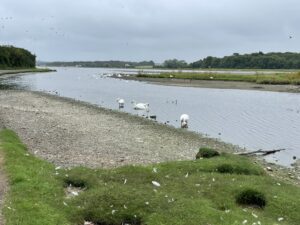
| Very low tide at the swannery promises dry feet further round the lagoon | Not exactly blazing June… |
 |
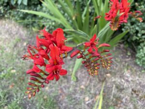 |
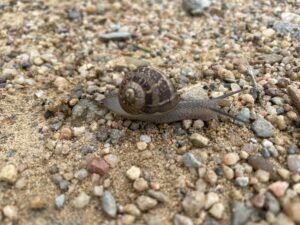
| …but at least the gastropods like it | Brilliant Crocosmia in Kilcrea Road, between the north shore of the Broadmeadow lagoon and the Newbridge estate |
 |
|
| Preparations in full swing for the “Flavours of Fingal” show taking place in the Newbridge demesne this weekend. I went last year, and it was pretty good | |
Interactive map
(Elevations corrected at GPS Visualizer: Assign DEM elevation data to coordinates )
Max elevation: 18 m
Min elevation: -3 m
Total climbing: 218 m
Total descent: -220 m
Total time: 03:29:12
You can read earlier and later days’ blogs below
Previous day’s blog
Next day’s blog
Ireland home page
 Save as PDF