
For technical types..
GPX files can be downoaded from here
The files are in the form of GPX “route” files and go from accommodation to accommodation, which means that there are extra pieces added on at the start and end of every day’s walk to get onto and off the PW. But every inch of the PW is covered! They are taken from published PW routes and may not be the actual route I cover when walking.
Once I have finished, I will post my actual track GPX files here, so it will be possible to compare the “theoretical” route with the “actual” track.
There is a map at the bottom to help locate the various daily stages
Note: This table will not display properly on smartphone screens as the right hand column spills over the edge of the screen
| Walking day | From | To | Mi | Ft | GPX | |
| Su, 21 Feb 2016 | 00 | Home | Edale | |||
| Mo, 22 Feb 2016 | 01 | Edale | Crowden | 16.73 | 2833 | 01 |
| Tu, 23 Feb 2016 | 02 | Crowden | Diggle | 13.97 | 2638 | 02 |
| We, 24 Feb 2016 | 03 | Diggle | Hebden Bridge | 17.39 | 2066 | 03 |
| Th, 25 Feb 2016 | 04 | Hebden Bridge | Ponden | 12.59 | 2564 | 04 |
| Fr, 26 Feb 2016 | 05 | Ponden | Gargrave | 15.93 | 2566 | 05 |
| Sa, 27 Feb 2016 | 06 | Gargrave | Horton | 21.52 | 3673 | 06 |
| Su, 28 Feb 2016 | 07 | Horton | Hawes | 14.09 | 1770 | 07 |
| Mo, 29 Feb 2016 | 08 | Hawes | Keld | 12.75 | 2468 | 08 |
| Tu, 01 Mar 2016 | 09 | Keld | Bowes | 12.87 | 1288 | 09 |
| We, 02 Mar 2016 | 10 | Bowes | Middleton in T. | 12.32 | 1557 | 10 |
| Th, 03 Mar 2016 | 11 | Middleton in T. | Langdon Beck | 8.95 | 1057 | 11 |
| Fr, 04 Mar 2016 | 12 | Langdon Beck | Dufton | 12.84 | 1496 | 12 |
| Sa, 05 Mar 2016 | 13 | Dufton | Alston | 20.26 | 3595 | 13 |
| Su, 06 Mar 2016 | 14 | Alston | Greenhead | 17.48 | 2129 | 14 |
| Mo, 07 Mar 2016 | 15 | Greenhead | Greenlee L. | 9.94 | 1982 | 15 |
| Tu, 08 Mar 2016 | 16 | Greenlee L. | Bellingham | 13.73 | 1597 | 16 |
| We, 09 Mar 2016 | 17 | Bellingham | Byrness | 17.98 | 2005 | 17 |
| Th, 10 Mar 2016 | 18 | Byrness | Kirk Yetholm | 26.45 | 4903 | 18 |
| Fr, 11 Mar 2016 | 19 | Kirk Yetholm | Home | |||
| Whole route | Totals | 277.79 | 42187 | 00 |
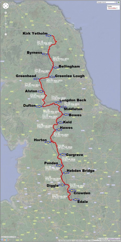
The map shows, geographically, where these places are located
 Save as PDF