Ireland day 0980. Tuesday 04 June 2024- Big Island 3
| Today’s summary | Leisurely breakfast then walked down to the coast 400m / 1300ft below our guest house. Had a quick look at the monument to where Captain Cook died in 1779 and had a swim and a snorkel in the clear water. Hiked back up again then to Keei café for dinner. Distant views were obscured by vog from yesterday’s eruption of Kilauea | ||||
| Today’s weather | Warm and dry with haze caused by the eruption. A brief shower in the evening. Light westerly wind. Appx 25c | ||||
 |
 |
||||
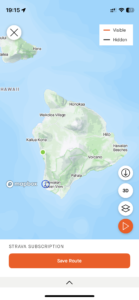
| Today’s overview location (The green mark shows the location of our route) |
Close-up location (The orange line shows where we walked) (Click button below to download GPX of today’s walk as recorded, or see interactive map at bottom with elevations corrected): Captain Cook memorial |
||||
Commentary
(Summary blog only. Last full blog was Day 0368).
We awoke this morning to a slightly unusual sight. Instead of the clear blue views to infinity that have been the norm lately, a greyish haze filled the atmosphere, blotting out the distant horizons.
Val did a bit of googling and discovered what it was. It turns out that the Kilauea volcano erupted yesterday, and what we were seeing today was the sulphurous aerosol it had ejected and which was now being blown in our direction by the trade winds. The haze is known as a “vog” and whilst it did obscure some of the views, it didn’t really bother us at all.
Once that mystery had been resolved, we had breakfast, inspected the impossibly lurid Jade Vine growing in the garden of our guest house, and then headed out for the day.
We only had a short way to travel – just up the road, in fact, to the start of the Captain Cook trail. We could have walked to the start straight from the guest house, but there is no pavement and the road was too busy. Once parked up, we set off down the path to the coast, some 400m / 1300ft below.
It’s an easy route, even though my AllTrails app described it as “hard”. The going is a bit rough in places, as it crosses a lava field, but nothing very difficult at all. Though it’s much harder coming up than going down, of course, and you have to make the ascent with the sun on your back, making it doubly uncomfortable.
Once down at the shoreline, we had a good look at the Captain Cook monument, commemorating the spot where Whitby’s most famous son died in 1779, following a dispute with the locals over a stolen boat.
Nowadays it’s a favourite swimming and snorkelling spot, and I spent a very happy half an hour using a borrowed snorkel to look at the fish and admire the coral while Val looked on from the safety of the shore.
After a snack lunch we slogged up to the top again – the ascent wasn’t too bad actually – perhaps the Grouse Grind and Koko Crater Tramway climbs have left us in better condition than we had thought.
We returned to our accommodation for a quick shower and to get changed, then headed straight back out again to Keei café for an excellent fish taco dinner. Now we’re back on the lanai again and the frogs are in full throat . Time for another early night – the tropical dawn chorus will be upon us in just a few short hours’ time!
Today’s photos (click to enlarge)
Interactive map
(Elevations corrected at GPS Visualizer: Assign DEM elevation data to coordinates )
Max elevation: 435 m
Min elevation: 0 m
Total climbing: 457 m
Total descent: -456 m
Total time: 04:06:01


