
Ireland day 1013. Sunday 07 July 2024- Kippure
| Today’s summary | A relatively lazy day today with no firm plans. So after lunch, we drove up to the Sally Gap and walked up the RTE access road to the summit of Kippure. It’s an iconic summit, visible from all over eastern Ireland, and we had never been before. It was a good choice – an easy walk with excellent views in all directions including over to Wales. Enjoyed the drive there and back, over the bleak wilderness of the Sally Gap – a million miles from Malahide but only an hours drive away. | ||||
| Today’s weather | Sunny intervals with massive billowy clouds and occasional showers. Light westerly wind. Appx 16c | ||||
 |
 |
||||
| Today’s overview location (The grey mark shows the location of our route) |
Close-up location (The orange line shows where we walked) (Click button below to download GPX of today’s walk as recorded, or see interactive map at bottom with elevations corrected): Kippure |
||||
Commentary
(Summary blog only. Last full blog was Day 0368).
Almost everywhere you go on the east coast of Ireland, the distinctive summit of Kippure is visible, clearly marked out by the transmission mast on its summit. It’s not a particularly spectacular hill, and at only 757 metres (2,484 ft), it ranks as the 56th highest peak in Ireland (though the mast adds another 127m / 417ft). So until today it had never really figured on our list of hills to climb in Ireland.
But with an otherwise free day today, and a reasonable weather outlook, we decided to correct this omission from our Irish itinerary and head out to have a look at this iconic summit.
The access to Kippure is very easy – there is an access road for the RTE transmission station which leads right to the top, so you just follow the tarmac all the way up. In that respect it’s very similar to Mt Leinster, which we climbed last year. To get to the start of the access track, we followed the Sally Gap road, which in itself was an enjoyable drive.
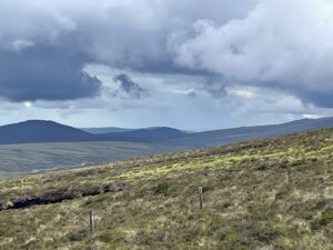
Once we were up the hill, the views were stunning. To the north, Dublin and the Cooleys beyond. To the south west, Mullaghcleevaun and Tonelagee, and to the east, Snowdon (Yr Wyddfa) in north Wales. But more ominously, a big black cloud was bearing down on us at great speed, so we didn’t hang about and retraced our steps to the car as soon as we had completed our circumnavigation of the summit.
The route up and down was decorated with unusual heath flowers and birds (Meadow Pipit being one) and we spent some time trying to identify them all.
We made it to the car without getting soaked and, once back, had some coffee and snacks. We returned to Malahide via the eastern half of the Sally Gap road, and really enjoyed the wilderness landscape along the way. It’s amazing to think that all this remote beautiful solitude is only 45 minutes from the centre of Ireland’s capital city, and only an hour from our flat.
Eventually, we made it back to Malahide and are now preparing ourselves for an evening with Echo and the Bunnymen and Arcade Fire. It’s the last of this year’s concerts and I have to admit it will be nice to have some slightly quieter evenings to look forward to. (There’s no cricket this year, by the way – apparently it costs too much to build the temporary stand alongside the demesne pitch and Cricket Ireland just couldn’t afford to swallow the loss. I think all this year’s internationals are being played at Stormont, in the North).
Well it’s time for dinner now and a couple of episodes of the Wire. More adventures to look forward to tomorrow!
Today’s photos (click to enlarge)
 |
 |
| At the start of the RTE track | On the road to the summit, with the mast on the distant horizon |
 |
 |
| Bog Asphodel, Narthecium ossifragum | Heath Spotted Orchid, Dactyolorhiza maculata. Looks very much the pyramidal orchids which grow in abundance in meadows near Malahide, but the flowers are lighter in colour and the inflorescence isn’t quite so densely packed |
 |
 |
| Looking west towards Mullaghcleevaun | On the top, proudly claiming the trig point |
 |
|
| Snowdon / Yr Wyddfa, 160 km / 100 mi away across the Irish Sea | |
Interactive map
(Elevations corrected at GPS Visualizer: Assign DEM elevation data to coordinates )
Max elevation: 752 m
Min elevation: 518 m
Total climbing: 250 m
Total descent: -250 m
Total time: 02:04:27
You can read earlier and later days’ blogs below
Previous day’s blog
Next day’s blog
Ireland home page
 Save as PDF