Ireland day 0298. Saturday 23 July 2022- Glencree
| Today’s summary | A circuit of the pathless boggy tops of the Glencree Valley taking in Tonduff and Loughs Bray upper and Lower. Finished up at Glencree Centre. An excellent day out – left feeling pummelled by the weather and by the terrain underfoot. Sadly Val couldn’t join us today as she was at work. | ||||
| Today’s weather | Heavy rain overnight, drizzly for most of the walk with some dry spells. No sun. Rain again in evening. Strong southwesterly wind, gale force on tops. About 18C | ||||
 |
 |
||||
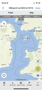
| Today’s overview location (The blue mark shows the location of our route) |
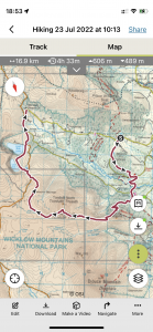
Close-up location (The green line shows where we walked) (Click button below to download GPX of today’s walk as recorded, or see interactive map at bottom with elevations corrected): Glencree southern tops |
||||
Commentary
As someone who comes from Yorkshire in the north of England, I sometimes have problems with my vowels. For example I pronounce “grass” as it should be, i.e. “grass” (not “grarse”, as they do in the south of England). Similarly, “bath” is “bath” not “barth”. But most controversially, “scone”, in my view, is correctly pronounced as “skonn” and not “scohne”. To use the latter pronunciation would have you labelled as a softie southerner, which would be awful.
I have already gone on at great length about the excellence of Irish scones and I have rapidly learned that one of the traditions of the Dublin Walking Club (which I am only too happy to endorse) is that the actual walk only starts once everyone has been properly fortified with tea and scones at a convenient café beforehand. But I found I had been running into difficulties asking for, in my view correctly, a “cup of tea and a skonn, please”. I was getting blank looks in return, and it has taken me several weeks of pointing at cakes in cabinets to indicate what I meant before the penny finally dropped that nobody here knows what a “skonn” is. Much to my surprise, I have discovered that the natives of this tough Celtic country pronounce these confectionary delights in the posh way, as “scohnes”.
So, much to my huge embarrassment, I have found that if I want to eat properly in the mornings, I have to adopt this what seems to me to be the affected “scohne” pronunciation – or else it’s just going to be endless blank stares from the waiting staff. I will just have to remember to adopt my original, north of England, pronunciation as and when I am in the UK, or else my street credibility will be shot to pieces.
Anyway, on with the day. Tea and scones (you know what I mean) were taken this morning in Enniskerry, after a swift lift-share down from Malahide. Then we headed up the road to leave the cars in Curtlestown car park. It had been raining hard overnight and first thing this morning – such a contrast with yesterday – but by the time we left the cars, it had mostly stopped. Throughout the day, we suffered intermittent heavy drizzle and reduced visibility in the low cloud, but that was as bad as it got. I didn’t even need my waterproof overtrousers. The most difficult aspect of the weather, actually, was the wind – near gale force on the tops, which made the going over the featureless boggy moorland even more precarious.
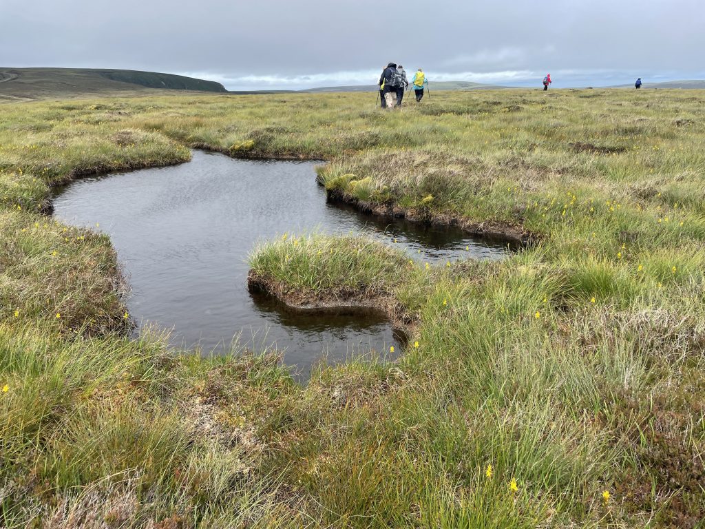
Our route followed the Wicklow Way up through Crone Woods until just below the top of Maulin. At that point we turned sharp right and headed east into an increasingly featureless and pathless area leading eventually to the southern summit of Tonduff. It required some careful navigation to find the top itself, as the mist was down and one bit of bog looks pretty much like the next!
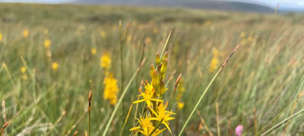
I was glad to be with the group up there, as I wasn’t certain where the best route lay – the leader had done a good job of recce-ing it – because there wasn’t much (i.e. any) evidence of the path on the ground. Eventually we located the summit and sheltered behind a peat-hag for lunch. It felt well earned as it had taken 3 hours of fairly hard walking to get there. But I loved it up there! Not a soul about, just the occasional skylark for company – and a bleak sub-arctic tundra, decorated by more bog asphodels, in full yellow bloom, than I had ever seen before in my life (you can see them in the banner image at the top). Beautiful.
From there we picked our way carefully down to the R115 old military road which links south Dublin to the Sally Gap (which is incidentally the highest public road in Ireland). A short distance down the road, we dropped down a path off the side to explore the beautiful twin loughs of Bray (Upper and Lower). They really are stunning – wild, lonely and impressively sculpted by the glaciers. And to my shame until today I didn’t even know they existed.
Eventually, we made it back to the road and then down to the Glencree Centre where with a bit of clever advanced planning a shuttle car had been parked, which meant that we could avoid a tedious 5km / 3mi slog back down the road to the main car park at Curtlestown. While waiting for our cars to come back up and collect us, we had a quick look round the Centre itself. You can read more about it in the photo caption below – suffice it to say that it has had a chequered and not always entirely happy past. But a fascinating spot which deserves more than the cursory visit we were able to give it today.
From there, it was a quick return journey to Malahide. Fortunately, given that I was hungry and tired, and Val was likewise after a tough day at work, it was an easy job to heat up some of the reduced-price beef casserole I had made the other day, and knock together some colcannon, to serve up another tasty and nutritious dinner in less than ten minutes. Sadly there’s no Malbec to go with it tonight, but with all the tea and scohnes for breakfast this morning, I’ve probably had more than enough empty calories for one day already.
Today’s photos (click to enlarge)
 |
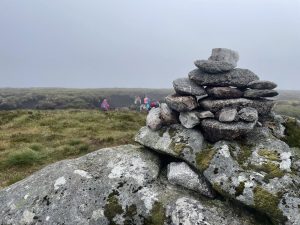 |
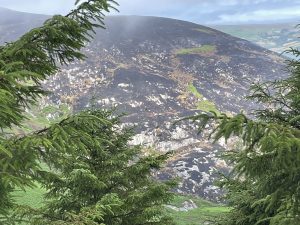
| There had been a big moorland fire on the south side of Glencree last week. Fortunately our route skirted round it but it had devastated a large area of heather and some forestry too. It was still smouldering this morning – though last night’s rain probably helped damp it down a bit | On the top of Tonduff (South summit) – 634m / 2080ft). It’s actually quite hard to find the top as it’s relatively featureless up there and nearly flat. Plus you keep dropping down into peat hags and groughs which make it hard to see the horizon sometimes. It’s just like Kinder Scout in Derbyshire, UK, used to be like, before the Pennine Way across it was paved |
 |
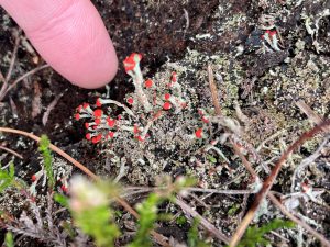 |
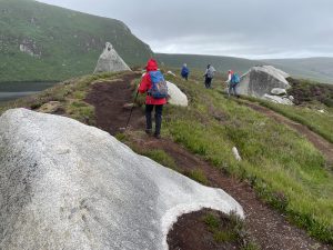
| On the ridge above Lough Bray Upper. The ridge itself is a curious geological feature – it feels glacial but it’s too big, and the boulders are too huge, for it to be an esker. Maybe actually it’s just an isolated ridge of solid rock that was left behind when the ice carved its way around either side of it | Devils matchsticks – I had never seen them before one of the others in the group pointed it out to me. It seems it’s a lichen (Cladonia floerkeana) and is relatively common on the drier parts of the boggy up-lands in Ireland – and presumably in the UK too. Like all lichens, it’s actually a symbiosis between a fungus and an alga. It’s usually a sign of relatively clean air. |
 |
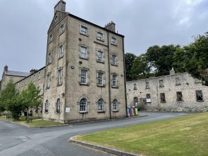 |
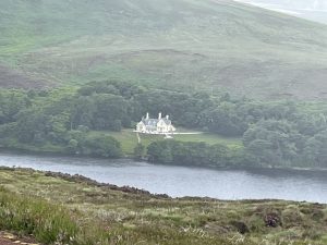
| Lough Bray House, on the secluded southern shore of Lough Bray Lower. It’s magnificent. It was build as a shooting lodge for the Powerscourt Estate in the 19th century but was subsequently sold to the Guinness family. It has been sold again several times since then, apparently, but nobody seems to know who owns it now. It is is surrounded by alarming looking “Keep Out” signs, so whoever it is clearly values their privacy. There is a rumour that at one time it was owned by Frederick “Day of the Jackal” Forsyth but I think he actually lived a bit further down the valley nearer Enniskerry | The Glencree Centre. It was originally built as a (rather grim) British military barracks after the failed 1798 rebellion. Then in 1858 it was handed over to become a “reformatory” for wayward juvenile males, run by a religious order. It was probably even grimmer then, and several of the boys tragically died. It was closed in 1940 and remained unused until 1946 when it became the headquarters for “Operation Shamrock” – a programme to re-house up to 1000 German children who were orphaned or separated from their parents during the war. In the early 2000s, the “Centre for Peace and Reconciliation” was established there – primarily with the objective of bringing communities affected by violent conflict in Ireland together, but also with international programmes in conflict zones further afield. The Prince of Wales has visited on at least two occasions. |
 |
|
| It’s quite hard going but I really like this featureless terrain. it reminds me of the Arctic and makes me feel like an Ice Age isn’t so far away. Requires careful navigation, though, and you have to watch where you put your feet. |
|
Interactive map
(Elevations corrected at GPS Visualizer: Assign DEM elevation data to coordinates )
Max elevation: 642 m
Min elevation: 98 m
Total climbing: 925 m
Total descent: -808 m
Total time: 05:46:59
You can read earlier and later days’ blogs below
Previous day’s blog
Next day’s blog
Ireland home page
 Save as PDF