Ireland day 0249. Saturday 04 June 2022- DryFeet!
| Today’s summary | Val was at work so as the weather was nice, I decided to walk round the lagoon to Newbridge. Purely by chance, the water level was the lowest I’ve seen it in months, despite it being close to high tide, so I was able to get round (just) without paddling | ||||
| Today’s weather | Dry all day. Overcast in the morning but full sun by lunchtime. Strong north easterly wind. About 13C | ||||
 |
 |
||||
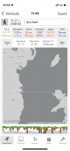
| Today’s overview location (The blue mark shows the location of my route) |
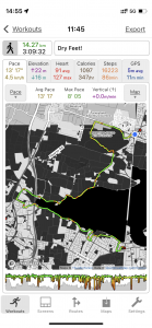
Close-up location (The green line shows where I walked) (Click button below to download GPX of today’s walk as recorded, or see interactive map at bottom with elevations corrected): Dry feet Newbridge walk |
||||
Commentary
On days like today, when Val is out at work, one of my favourite activities is to walk round the Broadmeadow lagoon to the Newbridge Demesne on the north side of the estuary near Donabate. I particularly enjoy this walk because you can mostly avoid road-walking, because there’s always lots going on in the lagoon – from windsurfers to swans – and because the Demesne is huge and empty (and has a nice café). I also have to admit I quite like the short train ride back again at the end.
The main disadvantage of this walk – or perhaps it’s an added excitement, depending on your point of view – is that along the north side, the path is under water at all but the very lowest of tides. So you either have to paddle, or walk via the Hearse Road – which is very busy, has no pavement, and is as grim as the name suggests.
I’ve droned on at great length in previous blogs, about my efforts to correlate the water level in the lagoon with the tide level in the main Malahide estuary at the other side of the railway embankment. Basically I’ve concluded that the water level in the lagoon appears to reach its lowest point several hours after the low tide in the main estuary – although it is equally likely that there isn’t actually any correlation at all. Perhaps the level just goes up and down randomly, controlled by some hidden sluice that I haven’t yet managed to identify.
Anyway the upshot of all this is that if I want to walk round to Newbridge, as I did today, I ignore the tide charts and just go – accepting that most likely I will have to paddle or do battle with the road.
So I didn’t really have any expectations when I set off today, except that the weather looked decent and there was definitely plenty of spring in the air (despite the biting north easterly wind) so I was hoping for a pleasant sunny outing. And it was. Saturday windsurfers were out in force, obviously enjoying the wind more than I was, and the wildlife was abundant. As well as the seagulls and swans, which are always around, the herons seemed to have returned today, from wherever they had been hiding for the last few weeks, and they were joined by min-me egrets, too.
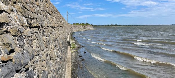
But the real surprise was on the north side, where the path in two stretches is normally flooded – or at least it has been the last five times I have been there. Because today, the path was (just about) passable, without getting wet feet. And this despite it being only about an hour an a half before high tide in the outer estuary. I’ve no real idea why, but I enjoyed the luxury of dry feet and didn’t ask too many questions.
After a brief pause in a sunny spot on the shore for lunch, I crossed over the bypass and the Hearse Road and went into Newbridge. I decided to try and walk round the perimeter but my way was blocked by the moat. Anyway a conveniently lightning-struck tree had fallen over it and in my best Indiana Jones style I shimmed across, dodging the crocodiles in the abyss below, and got to the other side.
Safely on the “right” side, I completed my walk round the perimeter and avoided the temptations of the café (which was heaving anyway) and made it to the railway station in Donabate with just seconds to spare before the Connolly-via-Malahide train pulled out. Once back in Malahide, I did a bit of shopping and am now about to start making dinner so it’s ready in time for when Val gets back. My work is never done, it seems.
Today’s photos (click to enlarge)
 |
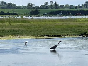 |
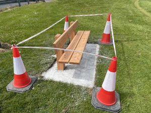
| The southern side of the lagoon, with the walkway to Swords, is a bit lacking in places to sit, so it was good to see a couple of these, newly installed, today | Egret (on the left) and heron (on the right). the both seem to occupy the same niche. it’s just that one is bigger than the other |
 |
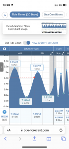 |
| There are lots of these wild roses in the countryside near us and at the moment they are all in full bloom. I think they look really attractive, and they even have a bit of a smell (which is somewhat unusual for wild roses) | Today’s tide chart for Malahide. According to this, it was just 1h 55m until the next high tide, yet the water level in the lagoon was already low, and didn’t seem to be rising in the 30 minutes after I stopped to have lunch, either. When I went over the sluice in the middle of the causeway on the train, when it would have been pretty much high tide, there didn’t seem to be much water flow through it in either direction – suggesting that the water level in the lagoon had already reached the level in the main harbour outside. Yet the lagoon shoreline still looked quite low. So I am really perplexed as to what is going on. |
 |
 |
| Surrounding the Newbridge demesne is this water-filled moat. There aren’t many crossing points so if you find yourself on the wrong side, you are stuck. Unless, of course, your luck is in and a handy fallen tree offers an alternative bridge | Obviously the temptation was too great and I simply had to go across just because I could. So I shuffled along the tree trunk, and safely got to the other side, pretending as I was crossing (and as a motivation not to fall off) that the ditch was filled with crocodiles, and feeling somewhat like Indiana Jones when I finished. |
 |
|
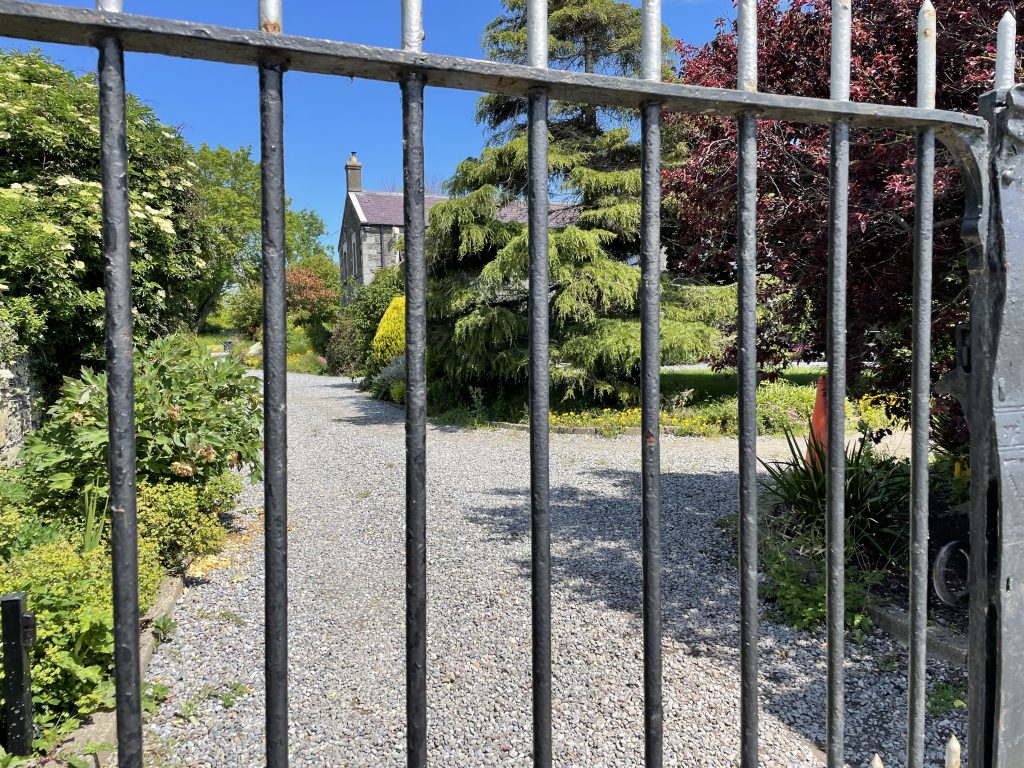
| On the north side of the lagoon, there are some lovely looking houses, like this one. But security is obviously an issue, judging from the locked gates and, in one case a bit further on, razor-wire on the wall top. | |
Interactive map
(Elevations corrected at GPS Visualizer: Assign DEM elevation data to coordinates )
Max elevation: 18 m
Min elevation: -3 m
Total climbing: 206 m
Total descent: -207 m
Total time: 03:09:31
You can read earlier and later days’ blogs below
Previous day’s blog
Next day’s blog
Ireland home page
 Save as PDF