Ireland day 0186. Saturday 02 April 2022- Lugnaquilla
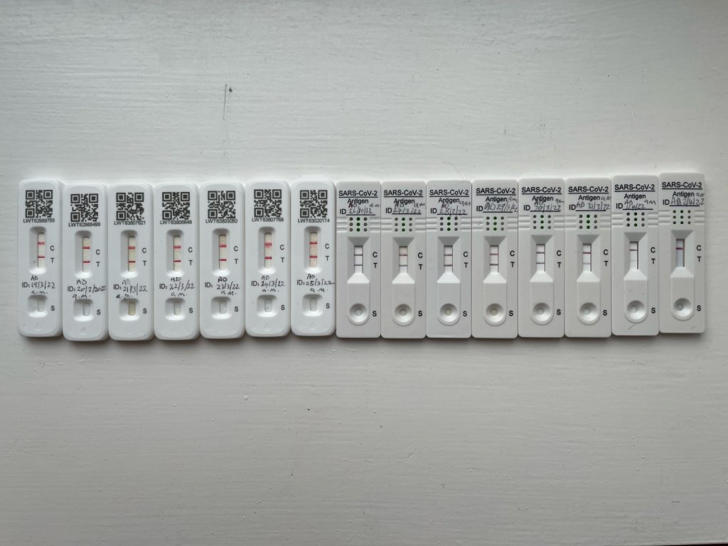
| Today’s summary | Tested negative for Covid first thing this morning, after 15 days. Hooray. Then drove down to Glenmalure for climb up Lugnaquilla, highest mountain in Wicklow, with the Dublin Walking Club. Excellent walk. Very small group though as everyone has Covid | ||||
| Today’s weather | Very wet and cool in the morning, dry and bright with occasional snow showers in the afternoon. Moderate northerly wind. About 6C in the valley, minus 1 on the top | ||||
 |
 |
||||
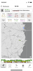
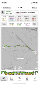
| Today’s overview location (The green line shows the location of our route) |
Close-up location (The green line shows where we walked) (Click button below to download GPX of today’s walk as recorded, or see interactive map at bottom with elevations corrected): Lugnaquilla from Glenmalure |
||||
Commentary
Today was one of those wonderful days that started well, and just continued getting better.
The wonderful start was a negative Covid test first thing this morning. Probably just about the first time in my life that I have actually been delighted to fail a test. After 15 days I thought it was about time too – and I am hoping that the Omicron XE variant stays away long enough for us all to enjoy some sort of immunity for a few weeks, at any rate. Anyway – it wasn’t too bad really. If we hadn’t been bombarded with daily updates about the coronavirus for the last two years, I think I would probably just have assumed I’d had a rather bad cold.
Anyway, with a bit of a spring in our step, Val and I headed off down the motorway and deep into the Wicklow Hills at Glenmalure. It’s about 90km / 55mi from here and about an hour and a half away. A straightforward drive – though it was pouring down on the M50 – and we got stuck behind a cycle race coming out of Laragh. But as you leave the motorway behind and climb into the hills, the scenery just gets more and more spectacular. All the hills we should have been walking through, in fact, if we had actually done the Wicklow Way!
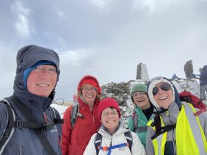
We were meeting up with the Dublin Walking Club for an ascent of Lugnaquilla today. But we were a sadly shrunken group as most – and I think I really do mean most – of the club is suffering from Covid at the moment. And of the five of us who completed the walk today, three of us had recently recovered. But it’s a shame so few could join us today as it was an outstanding walk.
But first a bit of context – Lugnaquilla – which probably means “hollow of the wood” in Irish would, if it were in Scotland, be a Munro, as it is over 3000 ft / 914 metres tall (it’s 3035ft / 925m, to be precise). There are thirteen such “Munros” in Ireland, although ten of them are in the MacGillycuddy’s Reeks range, on the west coast near Killarney. Lugnaquilla is the only one in the east. All thirteen are in the Republic; none are in the north though Slieve Donard in the Mournes is not far short. It’s also pretty remarkable, in my view, that Lugnaquilla is only one hour’s drive from the centre of Dublin. I feel lucky to live somewhere where “proper” mountains are so close at hand.
Lately – ever since Bev and Pete left, in fact – we have been having some unseasonably cool weather and a bit of rain – though it was only when we got to Glenmalure that I twigged that 6C and rain in Malahide meant freezing temperatures and snow on the tops of the mountains in Wicklow. Fortunately we had come with a good selection of bad weather gear so our plucky band set out enthusiastically into the clouds, up the “zigzag” path from Flemings Farm, ready for whatever the elements threw at us.
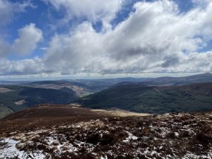
As we climbed, we soon ran into pretty continuous snow cover, and as the clouds intermittently descended and blizzarded us in snow, some careful navigation was called for. It was too cold to stop so we seemed to get to the top quite quickly – but in actual fact it took us almost three and a half hours. Occasional views opened up in the swirling mists, revealing stunning views of all the Wicklow Hills (lots of ideas for future walks!) and right out to the Irish Sea, 40 km / 25 mi to the east. We weren’t alone on the summit – it was a popular destination for local walkers today – especially the group who told us they love walking in snow, and had been sadly frustrated by its absence this winter. There was just time to shelter behind the trig point and get a quick cup of coffee from the trusty thermos, before turning on our heels and returning back down the way we had come up.
The original plan had been to do a circular walk from the top, but there were so few of us today that we didn’t have enough cars to make the logistics walk. And in any case, it didn’t really matter because the views on the way down were so completely different from those on the way up that I could easily have believed we were somewhere else altogether.
We found a sheltered spot about halfway down to enjoy a belated lunch, then completed our descent and were back at our cars just under seven hours after we set off. To be honest, I was really pretty surprised how long it had taken us. We didn’t feel to have been dawdling – though clearly we must have been to some extent – and the walk was so enjoyable that it actually didn’t feel like we had been away anything like that long.
Once back at the cars, we said our farewells and headed back round the motorway to Malahide. Altogether an excellent walk – one of the best I think we have done in Ireland – made all the more memorable by the appearance of the late season snow. What a contrast from last week when we were incarcerated in the flat, wondering if we could put our shorts on next time we went out. Not four seasons in one day, perhaps, but certainly in one week!
Today’s photos (click to enlarge)
 |
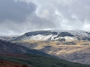 |
| On the way up, looking east towards the Irish Sea. The valley centre-left is Glenmalure, where we started out | Looking across the Glenmalure valley towards Tonelagee mountain. At 817m it’s the third-highest summit in the Wicklow Hills. Its name means – literally – “Arse to the Wind” in Irish |
 |
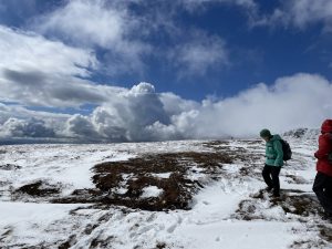 |
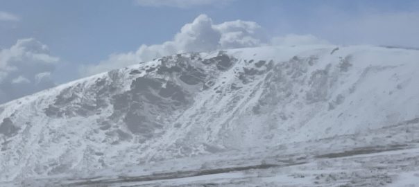
| A decent covering of spring snow on the way up | We were hit with squally snow showers – quite painfully icy – from time to time during the walk. But between the showers, the clouds parted to reveal the most spectacular views of the snow covered landscape. |
 |
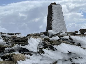 |
| Our small group from the Dublin Walking Club on the summit. All the men – except me – had got Covid! | Weather beaten summit trig point. It was pretty nippy up there so we didn’t hang around |
 |
|
| Yippee! After 15 days of Covid, I finally tested negative this morning. Feels good to be the other side of it, without too many side-effects. I did feel more tired than I would have expected after today’s walk – but put that down to having been pretty inactive for over two weeks while I was recovering | |
Interactive map
(Elevations corrected at GPS Visualizer: Assign DEM elevation data to coordinates )
Max elevation: 923 m
Min elevation: 131 m
Total climbing: 1028 m
Total descent: -1026 m
Total time: 06:51:58
You can read earlier and later days’ blogs below
Previous day’s blog
Next day’s blog
Ireland home page
 Save as PDF