Ireland day 0187. Sunday 03 April 2022- Liberator
| Today’s summary | Hiked up to the site of the 1942 Liberator air crash in the Cooleys, with the Boyne Valley Walkers. Then on up to the wild summits of Sliabh na gCloch. Weather was perfect – an astonishing contrast to yesterday | ||||
| Today’s weather | Dry and sunny all day. Light westerly wind. About 10C | ||||
 |
 |
||||
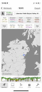
| Today’s overview location (The blue mark shows the location of our route) |
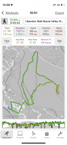
Close-up location (The green line shows where we walked) (Click button below to download GPX of today’s walk as recorded, or see interactive map at bottom with elevations corrected): Cooleys and Liberator crash |
||||
Commentary
At the height of the second world war (or the “Emergency” as it is known in Eire, which remained neutral throughout), Allied aircraft were involved in lengthy troop deployment flights between the UK and the theatre of war. On the night of 16 March 1942, a Liberator aircraft was undertaking one such flight – a lengthy 15 hour epic from Egypt back to the UK. It was carrying Wellington bomber pilots back to the UK to pick up a squadron of more new Liberator aircraft which would be in turn be flown back to Egypt to replace the smaller Wellingtons already stationed there. The B24 Liberator was a four engined American bomber, which looked a bit like the UK’s Halifax.
Unfortunately, the aircraft became disorientated en route and it wasn’t until the pilot spotted the lights of Dublin that it was realised how far off course they were. But by that stage they only had 30 minutes’ fuel left – and already two of the four engines had cut out. So the pilot decided to try and head north, across the border into Northern Ireland, and attempt an emergency landing somewhere in UK territory north of the Border.
Through an enormous stroke of bad luck, night fell, the navigation equipment failed, and the weather closed in as they headed north. Because of the engine failures, they could not climb high enough to get out of the cloud to try and navigate by the stars. So instead they decided to descend to try and come out below the cloud so that land based features could be identified. By this stage though, the plane was already in the foothills of the Cooleys and by the time they emerged through the cloudbase, they were too low and couldn’t climb fast enough to avoid hitting the hillside.
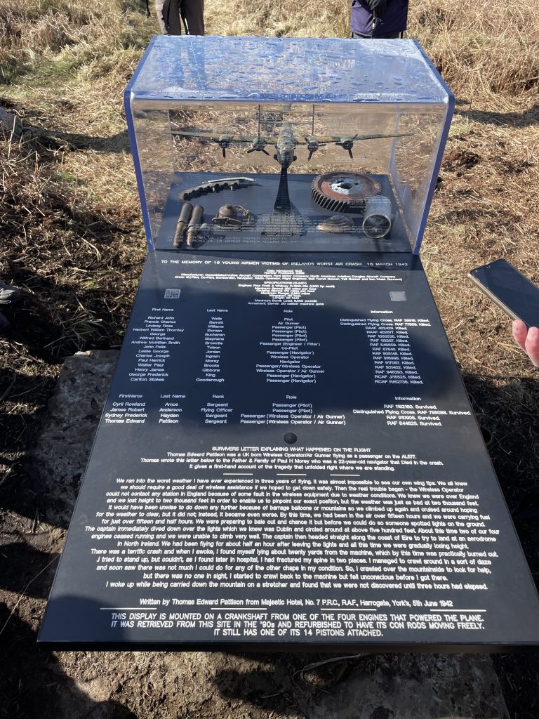
In the crash fifteen of the nineteen on board died, making it the worst wartime aircrash in Ireland. How the remaining four survived is anybody’s guess. Maybe they were all in the back of the plane at the time? What is even more remarkable is that the survivors were eventually all rescued some three hours later – there were very few people living in the area at the time, and it was late at night, so it’s really not known how anyone nearby even knew that the crash had happened.
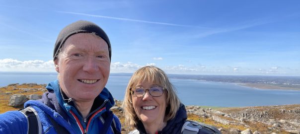
Anyway, the crash site in the Cooleys, on the side of Sliabh na gCloch, is still accessible if you know where to look, and nowadays is marked with an impressive memorial featuring a model of the crashed Liberator aircraft. Bits of the aircraft wreckage are sill visible strewn around the site, eighty years after the event, but rapidly being consumed by the encroaching bog. Fortunately, the Boyne Valley Walking group knew where to find it, so led a group of us up the hillside today, to find the wreck site, and then to climb further up into the fascinating summits of Sliabh na gCloch itself.
All in all it was a stunning day out – sparking sunshine and fantastic views all round. A complete contrast to yesterday! We had a sobering look around the crash site itself, then headed up to the summits, pausing for lunch at a beautiful small lough just below the top. It even had a rudimentary swimming platform though I think you’d have to be pretty hardy to attempt it at the best of times, let alone in early April.
From the top, we headed down through the forestry and were quickly back at the car park. We debated going in to the pub for a drink but it doesn’t mix well with driving – and I’m not really a fan of low alcohol beer – so we decided to head straight off once we got back. Besides, we needed to drop into Drogheda en route – partly to do some shopping and also partly to sort out a problem with our mobile phone bills. (Basically our monthly bills had suddenly gone up by 100% so we went into the Eir shop to try and sort it out – which the helpful manager was able to do on the spot. It’s great when you get a real person who knows what they are doing – saves hours of frustration on the line to call centres who often seem to specialise in sending you round and round in self-defeating circles).
Once we’d picked up our bits of shopping at the massive Drogheda Tesco (we managed to get some of the elusive anchovies today, by the way), we headed back down the motorway to Malahide in time for tea. We had sausages, colcannon and beetroot tonight – an unlikely combination I know but actually very enjoyable. Now it’s time to complete the Ireland 2022 Census. Because tonight is census night! I wonder what people will make of it in 100 years time, when it is released from the national archives. Will anyone look at our return? And wonder what we were doing here? Or what it was like to live through a pandemic? Some interesting questions to ponder over our sausages and gin.
Today’s photos (click to enlarge)
 |
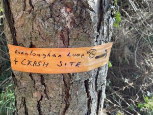 |
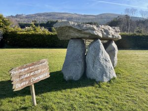
| The faux dolmen outside Fitzpatrick’s pub where we parked. It was installed by Duffy Concrete and I wondered if they were also responsible for the faux dolmen at the poc fada start site on the slopes of Anaverna? | Curiously the start of the path up to the Liberator crash site is marked with a large sign which says “no trespassing”. But then as soon as you are out of sight of the sign, a number of “official” waymarks, and unoffical tags like this, show the route quite clearly (The crash site is shown in the big picture at the bottom) |
 |
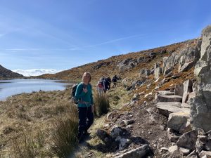 |
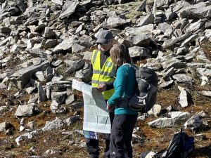
| Just beyond the crash site – here’s Val getting some navigation lessons | We had lunch alongside this beautiful lough tucked away between the summit crags. It doesn’t seem to have a name on any map that I could find, but it’s just below the summit of Slievenalogh (which unhelpfully and recursively I think means “Hill of the Lough”) |
 |
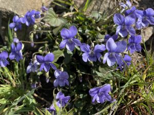 |
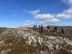
| On the top of Sliabh na gCloch (310m / 1017ft). On a day like today it was an absolutely beautiful spot, with massive open views in all directions and a fantastic sense of space. But on a day like when I’ve attempted my previous two traverses of nearby Carnavaddy – or on the night of 16 March 1942 – I imagine it could be a bit bleak | The route back down to the car park passes through a section of forestry that was burned down during one of the lockdowns in 2020. But now the recovery has already started, and today it was a profusion of wild flowers – like these beautiful violets on a sunny bank – and ferns. Nature’s healing in action. |
 |
|
| The memorial to the crashed Liberator aircraft was installed on 16 March 2022 – the 80th anniversary of the accident. There were nineteen airmen in the plane at the time, and fifteen perished. Even more remarkable is that four actually survived – and were rescued despite the fact that it was late at night and hardly anyone lived nearby at the time. How anyone ever found them is something of a miracle. | |
Interactive map (scroll to zoom)
(Elevations corrected at GPS Visualizer: Assign DEM elevation data to coordinates )
Max elevation: 308 m
Min elevation: 5 m
Total climbing: 451 m
Total descent: -451 m
Total time: 03:55:22
You can read earlier and later days’ blogs below
Previous day’s blog
Next day’s blog
Ireland home page
 Save as PDF