Ireland day 0158. Saturday 05 March 2022- Mullacor
| Today’s summary | Another amazing day for weather. Drove down to Glendalough to do a decent circular hillwalk with Dublin Walking Club taking in the Spink, Mullacor and Derrybawn Ridge. A really good leg stretch | ||||
| Today’s weather | Bright and sunny all day. Slightly more haze than yesterday. Light northerly breeze, moderate on the tops. About 6C lower down, closer to freezing on the tops | ||||
 |
 |
||||
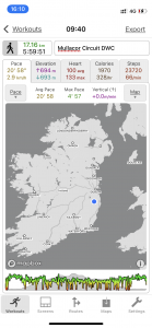
| Today’s overview location (The blue mark shows the location of our route) |
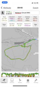
Close-up location (The green line shows where we walked) (Click button below to download GPX of today’s walk as recorded, or see interactive map at bottom with elevations corrected): Mullacor |
||||
Commentary
I thought that yesterday’s trip to Howth was pretty spectacular but today probably even topped it. The objective was to go into the heart of the Wicklow mountains with the Dublin Walking Club and complete a circular walk from Glendalough up a nice group of hills to the south of the valley.
“Glendalough” by the way is a corruption of the Irish “Gleann an dá locha” which roughly translates into “Valley of the Two Lakes” – and there are indeed two. It’s a bit of a magnet for hikers, as the valley is one of Ireland’s most beautiful and it is surrounded by attractive rounded hills which are just crying out to be climbed. And, as a pleasant surprise, there is a reasonably extensive network of footpaths, many of which are board-walked and well maintained. It’s only about 40km/25mi south of Dublin as the crow flies, and 55km / 35 miles from us here in Malahide.
The main drawback for today’s walk was that an early start time was called for, given the popularity of the destination and the shortage of car parking. So we were meeting at 9:30 am which in turn meant an 8:00 start from Malahide and – even worse – a 7am getting up time. Ugh. But it was definitely worth it. The drive down was straightforward and relatively quick – I still haven’t got used to how fast you can get places when you aren’t relying on public transport! So we were walking by 9:30 promptly and just had time for a quick look round the ancient monastic settlement by the Lower Lough – originally founded by St Kevin (an unlikely sounding name for a saint I agree, but there you go) around 600AD. It’s an absolutely fascinating place and we will definitely be planning a return visit in the near future.
Once we had reached the shores of the Upper Lough, the path made and abrupt turn south and started climbing steeply up out of the valley, alongside the Poulanass waterfall. The climb continued pretty unremittingly, up paths which were frequently and alarmingly glazed in black ice, to the Spink and then up Mullacor itself – after a brief pause for lunch in the shelter of some woodland near the top. I think Mullacor, at 661m / 2169ft is one of the highest points in Ireland that I’ve scaled since arriving last year. It’s a nice little hill, a bit off the beaten path and as a result (unlike the path lower down which was quite crowded), not too busy.
The views from the top were stunning, with the last vestiges of the snow from a couple of weeks ago still visible on the summit ridge of Lugnaquilla, the highest peak in the east of Ireland. From the top we headed west then pivoted north onto the Derrybawn Ridge. It’s said by aficionados of the area (who are, admittedly, biased) to be the finest ridge walk in Ireland. Not because of its lofty altitude or its spectacular drops, but because of the wide open views which it affords on all sides. I have no idea whether it really is the finest ridge walk in Ireland because I haven’t done them all, but it was certainly spectacular.
By the time we got to the end of the ridge, my legs were actually beginning to feel tired! Yesterday’s Howth walk was quite a stretch too, coming less than 24 hours before today. But it was a bit of a reminder that I’ve got somewhat out of condition since coming to Ireland – plenty of coast walks but too much Guinness and Christmas pudding I think.
We made a swift descent back to the valley and the cars, then met up at the Lynhams Hotel in Laragh for a quick drink to round off a perfect day – one of the best, in fact – before zooming back up the M11 to Dublin. And by the way I have discovered an unpleasant side-effect of having a car – you can’t drink. The ambience in the pub was good, however, and the pint of Heineken 0% was tolerable as I was thirsty. But not a patch on a proper pint of Guinness, even though it is probably marginally less damaging to my waistline!
Today’s photos (click to enlarge)
 |
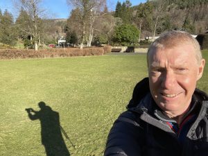 |
| Setting out from Glendalough with the “iconic” round-towers, about a thousand years old, in the ruined monastic settlement. A beautiful day | Here I am not so bright eyed and bushy tailed, given the 7am start |
 |
 |
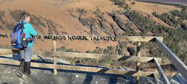
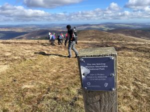
| Descending from Mullacor, leaving the Wicklow Maountains national park. Oddly, we re-entered it again about 100 metres further down the path | Looking out to sea from the Derrybawn ridge. A bit too hazy to see across to Snowdonia today |
 |
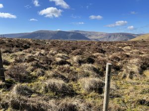 |
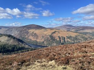
| Looking down to the Upper Lough in the Glendalough valley | The high point in the distant centre of the picture is Lugnaquilla – highest point in Wicklow at 925m / 3035ft so in Scottish parlance just about qualifies as a Munro. The club is planning a hike there in April and I’m hoping to go |
 |
|
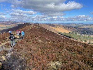
| Heading onto the summit ridge of Mullacor after lunch. In the sun and out of the wind, it was actually very warm but as soon as you headed out of the shelter, you felt the full blast of the cold northerly wind and it was pretty nippy | |
Interactive map
(Elevations corrected at GPS Visualizer: Assign DEM elevation data to coordinates )
Max elevation: 659 m
Min elevation: 128 m
Total climbing: 1055 m
Total descent: -1055 m
Total time: 05:59:43
You can read earlier and later days’ blogs below
Previous day’s blog
Next day’s blog
Ireland home page
 Save as PDF