Ireland day 0264. Sunday 19 June 2022- ScotchVillage
| Today’s summary | Val and I picked up a couple of Walking Club friends near Malahide and we all drove down to Roundwood for a Club walk up to the ruins of Scotch Village, not far off the Wicklow Way above Lough Dan. An excellent day out, especially in the sunshine in the afternoon. | ||||
| Today’s weather | Overcast and cold in the morning, sun in the afternoon. Strong westerly wind. Dry all day. About 13C | ||||
 |
 |
||||
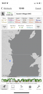
| Today’s overview location (The blue mark shows the location of our route) |
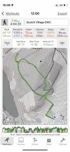
Close-up location (The green line shows where we walked) (Click button below to download GPX of today’s walk as recorded, or see interactive map at bottom with elevations corrected): [download coming soon] |
||||
Commentary
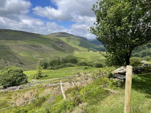
Scotch village is an enigmatic spot, marked on just a few rare-ish maps of Ireland, and situated on the western hillside of the Luggala Valley. The Luggala Valley is, in my opinion, one of the most attractive in county Wicklow. You can see it from the JB Malone monument on the Wicklow Way – where we had first spied it – and it runs between the two beautiful loughs of Tay (AKA the “Guinness Lake”) in the north, and Dan, to the south. It’s only short – under 3km / 2mi – but part of its attraction is that it is almost completely inaccessible. It’s all privately owned, and the local landowners seem to be a bit sniffy about allowing anyone on it, so the best you can hope for is to look down and admire it from above.
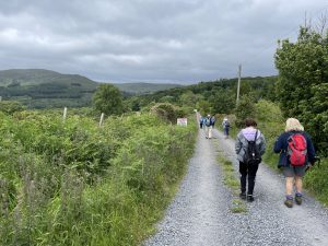
Our objective today was to join a few members of the Dublin Walking Club who knew the area well, and to head over to the village to see if we could learn a bit more about it. So, with an eye on petrol costs, Val and I drove down to Portmarnock to pick up another couple of walking club members, and the four of us shared the car for the ride to Roundwood. Here we stopped for the obligatory coffee and a scone then met up with the rest of the group before heading up into the hills to a small car park where we started the walk.
Once again, it was a cool – but dry – day, so the going was good. But then shortly after we set off, I had a sense of déjà vu – this all seemed awfully familiar. Finally the penny dropped. We had walked this way less than a month ago, on the stretch of the Wicklow Way from Enniskerry to Roundwood. So we stuck to the recently-familiar Wicklow Way for half an hour or so, then branched off into the woodland, following a forestry track across the hillside to the elusive dot on the map which marked the village.
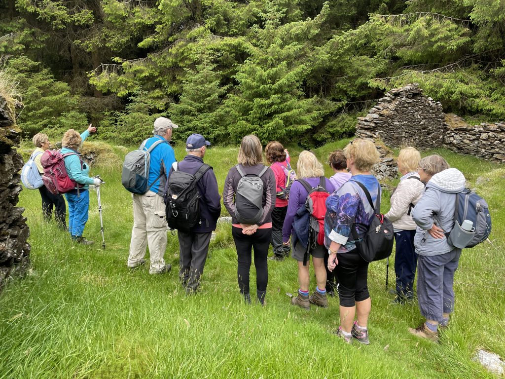
You suddenly come across the village in a glade at the end of the track. It’s a relatively unknown spot, so there were only a couple of other people there when we arrived. As it happened, one of them was a local historian who was able to give us a view on what the village was, and how it had come to be abandoned.
Until that point, the perceived wisdom that I had picked up was that the “Scotch” village was indeed populated by people from Scotland, who had either been brought, or had come of their own volition, to this spot to help the local community to become skilled weavers. The idea seemed to be that by learning different skills, the locals could earn additional income to supplement the more-or-less subsistence farming which prevailed in these parts at the time. However, the story goes, the 1845 famine struck soon after the Scots arrived so they, like the locals, either starved or emigrated (mostly to Canada) and the village was abandoned. So now all that remains are the crumbling ruins.
But the local historian who we chanced upon amongst the ruins had a slightly different tale to tell. In her version of events, the Scots had come to the village somewhat earlier – possibly sometime in the second half of the seventeenth century. They had been dispossessed of their land in Scotland as a result of the Highland Clearances at the time (there’s another long and unhappy story to tell there, too, but that can be for another day). However, by some quirk of fate that was glossed over today, their plight came to the attention of Peter La Touche, who lived in Luggala lodge – close to where the Scotch village is situated today. He was a wealthy banker and philanthropist. So he rescued a band of these dispossessed Scots and brought them over to the Luggala valley – to what is now Scotch Village – to start a new life.
Unfortunately, lightning struck twice and more or less as soon as the families had escaped the Clearances, they or their descendants were hit by the Irish famine. However, the La Touche family came to the rescue again and bought them passage to Canada – so once more they escaped to a new land to start afresh – but leaving the village to collapse into ruin. The La Touche family themselves were emigres – Huguenots who arrived in Ireland from France after the Edict of Nantes was revoked in 1685, depriving French protestants of religious and civil liberties. So I imagine they felt a degree of communality with the Scots’ plight. (By the way, as far as I can tell, these La Touche bankers were not related to the Touche family that went on to form Deloitte’s)
I’m pretty sure I misheard or misinterpreted some or even large parts of these stories, but there are almost certainly grains of truth in both of them. Whichever is true – and even if neither are – they make a fascinating tale and a useful reminder of the uncomfortable relations that have exist between religion and politics – not just in Ireland recently, but right across Europe – and probably beyond – for many centuries.
So after that unexpected but enchanting history lesson, we headed a little further through the woodland to get a view of the Luggala valley, which is blocked off to public access by barbed wire fences. This is a great shame, because it looks beautiful. From the ruins, we headed a bit further up Ballinafunshoge (what a wonderful name for a hill!) and re-joined the Wicklow way higher up. A quick walk down the Way saw us back at the cars just as the sun was coming out and a lovely late afternoon beckoned.
Once the Portmarnock group were reassembled, we made our way back round the M50 and home. Then this evening Val and I decided to push the boat out and get a takeaway dinner (a rather good curry, actually). I know it’s not exactly in keeping with our cost-of-living-crisis-management-programme, but in our defence its the first since coming to Ireland and I think one in nine months is probably not excessive.
Anyway, tonight’s Castle concert (Gerry Cinnamon) is just finishing now and the crowds are heading to the station to try and get home. It’s organised chaos down there at the moment but if the pattern of previous nights is repeated, the crowds suddenly disappear at about midnight and a deathly hush descends over this recently-thronging hub of humanity. A bit like the Scotch village, I suppose
Today’s photos (click to enlarge)
 |
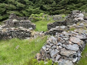 |
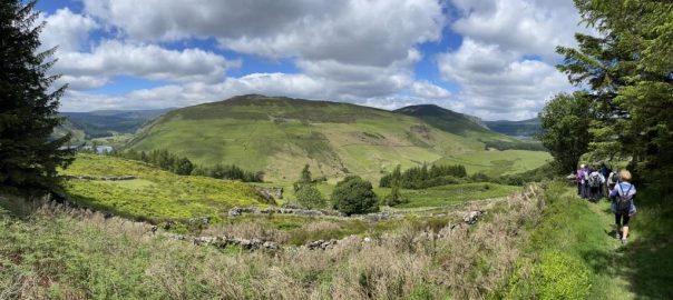
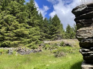
| Setting out from the cars, heading towards the Luggala valley. After I’d gone a couple of hundred meters, I suddenly realised that it looked familiar – it was actually a section of the Wicklow Way, between Enniskerry and Roundwood, that we had walked more or less exactly four weeks ago today. | The village itself – all in ruins now, but you can still see the freshwater well which was the water supply, and the stone blocks which the grain store was built on, to prevent rats from getting in. |
 |
 |
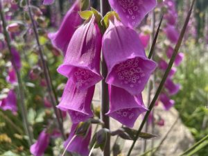
| I don’t think I’ve ever seen quite so many foxgloves (Digitalis purpurea) in one place. It contains a poison – digitoxin – which is also sometimes used (in the right dose!) as a drug to treat some forms of heart failure | A different view of the village – it’s quite extensive actually, and some of it continues into the area now gripped in the deadly embrace of the forestry |
 |
 |
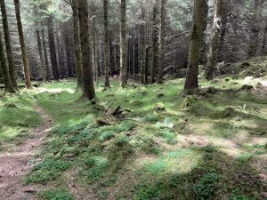
| In the woodlands heading towards the Luggala lookout. It’s a shame so few people come here, as it’s lovely | The view is beautiful but the barbed wire stopping you going any further isn’t |
 |
|
| Getting an impromptu history lecture amongst the ruins. A nice, peaceful spot. | |
Interactive map
(Elevations corrected at GPS Visualizer: Assign DEM elevation data to coordinates )
Max elevation: 464 m
Min elevation: 267 m
Total climbing: 319 m
Total descent: -319 m
Total time: 04:03:37
You can read earlier and later days’ blogs below
Previous day’s blog
Next day’s blog
Ireland home page
 Save as PDF