
Ireland day 0241. Friday 27 May 2022- Donard
| Today’s summary | Got up early and drove North to climb Slieve Donard, Northern Ireland’s highest summit (850m / 2790ft) from the coastal town of Newcastle. A beautiful walk, and completes my ascent of the highest summits in all five countries in the British Isles | ||||
| Today’s weather | Bright, dry and sunny with occasional cloud. Strong westerly wind at sea level but gale force and more easterly at top. About 16C at the bottom, probably nearer 10C on the summit. | ||||
 |
 |
||||
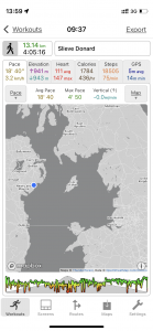
| Today’s overview location (The blue mark shows the location of my route) |
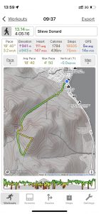
Close-up location (The green line shows where I walked) (Click button below to download GPX of today’s walk as recorded, or see interactive map at bottom with elevations corrected): Slieve Donard from Newcastle |
||||
Commentary
I fulfilled a longstanding ambition today. There are five countries in the British Isles (not including the Isle of Man and the Channel Isles) and as of today, I’ve reached the top of the highest mountains in all of them: Scafell Pike (England), Snowdon / Yr Wyddfa (Wales), Ben Nevis (Scotland), Carrauntoohil (Republic of Ireland) and now, today, Slieve Donard in Northern Ireland. It’s taken me a long time but Slieve Donard was definitely worth the wait because it is a real gem. I’m sorry that Val wasn’t with me to enjoy it, as she’s still in London, but that does give us the perfect excuse to go back and do it again soon.
The morning started a bit indecisively, actually. A couple of days ago, from the top of Paddy’s Hill I had seen the Mountains of Mourne – of which Slieve Donard is the highest – looming in the distant north. Almost ever since we arrived in Ireland, I have been remarking how they looked “alluring” and that one day I should go up there and have a good look round. So although the vision on Paddy’s Hill didn’t effect a biblical conversion, it did get my mind working. I thought that perhaps now that the weather was looking stable, I should make an attempt sometime soon.
But back to the indecision. I woke up just after six this morning when the first DART beeped its way out of Malahide station. Normally I can sleep through this disturbance but for some reason today it woke me up. So I got up and decided to make a cup of tea and go back to bed for a bit. But once I was up and about and I opened the curtains, I realised that this early start. combined with perfect-looking weather, might be the best opportunity to cut the dither and succumb to the allure.
So I did. By the time I’d had my breakfast and made my packed lunch, it was going up to 8 am when I set off. It’s a reasonably long drive – up north and across the border – to the starting point in Newcastle (not that Newcastle – this one isn’t upon Tyne) but I was still able to get parked and start walking by 9:30 am.
I chose the most popular ascent route – via the Glen River – and the great thing about it is that it’s one of those “no messing” routes – where you go up and up and up, with no height-wasting descents en route. Although Slieve Donard isn’t a “Munro” in Scottish parlance (i.e. at 850m / 2790ft it’s below the Munro threshold of 914m / 3000ft) it’s a pretty decent hill and as you start from practically sea-level, it feels like a good climb. I got up it a bit quicker than I expected – I’d read about people taking 3 hours for the ascent but I was up in 1hr 40 mins.
The climb was enjoyable, with spectacular views opening up in all directions as I ascended. Looking back on the way up, there were fine panoramas back down to the coast at Newcastle, and beyond to the flatter areas towards Belfast. The sun shone almost all of the way, but even though the air temperature was in double-digits, the strong to gale force headwind made it feel a lot colder. I am well and truly weatherbeaten now!
When you get up to the col between Slieve Commedagh to the right, and Slieve Foy to the left, you meet the Mourne Wall. This isn’t a form of mountaineer’s sugar deficiency – rather it’s a granite construction about 1.5m / 5ft tall which runs round all the summits of the Mournes. It was built over 18 years between 1904 and 1922 and is 32 km / 20 miles long. It was built to keep sheep and other livestock out of the catchment area of two (hidden from sight on today’s walk) reservoirs in the Silent Valley, which provide drinking water for Belfast. It mustn’t be deemed necessary to do this any more now, as it has been breached in a couple of places and no repairs were evident.
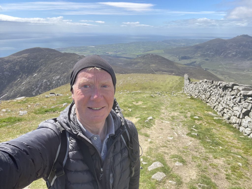
Once on the summit itself, there’s a big stone cairn (I was almost blown off when I puristically climbed to the top) and a solid stone shelter with the trig point curiously adorning its roof. I found a sheltered spot in the sun and out of the howling gale, to enjoy the view over to the Isle of Man and have my lunch.
To vary the walk a little, I added a short loop from the summit, descending south rather than back the way I had come up, which was from the west. Then I looped back along the “Brandy Pad” path to the col and back down the Glen River. I was back at the car by 1:45pm so the whole trip took just about 4 hours, including a 30 minute stop on the top.
I finished off my lunch in the car park, then drove to Tesco at Newry. I wanted to pick up some cheap wine (which I successfully did) – there isn’t a minimum price for wine in the North like there is in the Republic, so I was able to pick up a couple of bottles (well six, if you must know) of red wine for £3.60 whereas the cheapest down here comes in at €8 (about £6.50). Goodness knows if it will be drinkable or not – but it’s the principle that counts.
I was impressed with the Mournes. Admittedly the weather today was near-perfect, but they were a far more spectacular range of mountains than I had expected. There’s lots more exploring to be done here, and I hope we will both be able to come back soon to finish off what I started today.
Today’s photos (click to enlarge)
 |
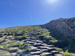 |
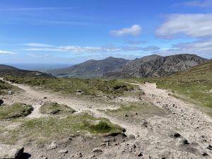
| Looking back north east towards the beaches of Newcastle with Dundrum Inner Bay the body of water in the middle distance | Most of the way up to the top of Slieve Donard is well paved – by the National Trust, presumably. It makes the ascent very easy, and you keep dry feet and can’t get lost. But it’s very hard on the feet on the way down |
 |
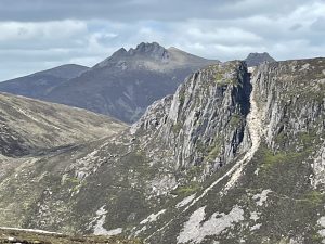 |
| The summit “cairn” on the top of Slieve Donard. The “cairn” is actually hollow and there’s a shelter inside. The trig point sits on the roof. | I had no idea the Mournes were “real” mountains like this! The summit in the foreground with the chasm is (I think) Slieve Beg and the chasm is known as the Devil’s Coachroad. The spiky hill in the background is Slieve Bearnach (I got the names from the map and also from speaking to someone on the top but he had such a strong Ulster accent I might not have heard them correctly – so take these identifications with a pinch of salt!). |
 |
 |
| When you reach the summit you get brilliant views to the west – the hills in the distance are probably the Cooleys, and at one point it was possible to see the radio mast on the top of Black Mountain, which we climbed a couple of weeks ago with the walking club. | Returning up the Brandy Pad path (see below), back up to the Mourne Wall at the col between Slieve Commedagh and Slieve Donard. You climb over the wall then it’s a straightforward quick descent back to Newcastle, by the Glen River |
 |
|
| Heading back down. I went up the Glen River way, reaching the summit from the west. But I descended to the south and then looped back to meet my original path at the saddle. If you continue on this path then turn left, rather than right to return to the saddle, you come to the Bloody Bridge river. This is another popular ascent route and uses a path called the “Brandy Pad”. | |
Interactive map
(Elevations corrected at GPS Visualizer: Assign DEM elevation data to coordinates )
Max elevation: 847 m
Min elevation: 5 m
Total climbing: 923 m
Total descent: -923 m
Total time: 04:05:31
You can read earlier and later days’ blogs below
Previous day’s blog
Next day’s blog
Ireland home page
 Save as PDF