Ireland day 0210. Tuesday 26 April 2022- Corlea
| Today’s summary | Drove out to the OPW site at Corlea to inspect the 2100 year old wooden trackway recovered from the bog. Time for a short walk round the disused Bord na Móna workings surrounding the visitor centre, then drove back via Mullingar | ||||
| Today’s weather | Dry and bright with long sunny intervals. Moderate easterly wind. About 13C | ||||
 |
 |
||||
| Today’s overview location (The blue mark shows the location of our route) |
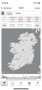
Close-up location (The green line shows where we walked) (Click button below to download GPX of today’s walk as recorded, or see interactive map at bottom with elevations corrected): Corlea Trackway loop |
||||
Commentary
Ireland is sort of shaped like a saucer. The higher level mountainous lands are generally out towards the coasts, whereas the the centre is lower lying and relatively flat. The heavy rain that falls over much of Ireland drains into the central bowl and tends to collect there in lakes and rivers – and bogs. In fact as much as one sixth of Ireland is covered in bog, which has been accumulating since the end of the last Ice Age, ten thousand years ago.
Until relatively recently, the turf (which is how peat is generally known here) which accumulates in the bogs was one of Ireland’s major sources of energy. It was dried and then burnt in both power stations for electricity generation, and for domestic heating in homes. The Bord na Móna (“Peat Board”) was set up as a part government-owned body to oversee the exploitation of this resource. I’d heard that when you travel round the central bowl of Ireland these bogs are very much in evidence, but today this was the first time we had seen them for ourselves.
The environmental impact of peat harvesting is unmistakable – the scraped earth tends to be covered in scrub and filled with shallow lakes. It doesn’t appear to be suitable for any form of agriculture. Partly because of the environmental impact, Bord na Móna has announced that it will be phasing out peat harvesting during the 2020s. But since turf is central to many aspects of Irish culture and heritage, this is not an uncontroversial decision.
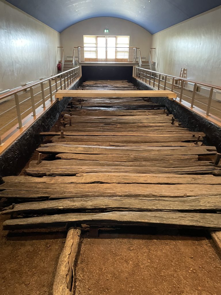
Anyway the reason why we were hanging about in the bogs today was that we were visiting the site of the Corlea Oak Trackway. Since the visitor centre is run by the OPW, we knew it would be good – and indeed it was. But what’s so interesting about a wooden trackway? Well for a start, it’s over 2000 years old, which makes it pretty unique. But perhaps more interesting, it has no obvious purpose.
The trackway was uncovered by Bord na Móna in 1984 when they were harvesting in the area. The bog chopping machine ground to a halt when it encountered a huge chunk of oak wood. Fortunately the machine operator had the presence of mind to stop and check out what was happening. It was quickly realised that the machine had unearthed something of archaeological interest and it’s to the credit of Bord na Móna that all harvesting in the area was stopped.
Subsequent archaeological investigations revealed that the wood had come from a submerged trackway about 1km long, 3 metres wide and running roughly northwest in a dead straight line. One of the many curious features of the road is that it seems to start nowhere in particular and finish abruptly in the middle of nowhere else. Another the unexpected finding was that, by dendochronological and radiocarbon dating, it was possible to tell that the whole thing was built by the local tribe of Celts over the winter of 148-147 BC, from around 300 large oak trees all felled in the summer of 148 BC. It seems likely that the road was built in the winter because the colder weather at the time would have ensured that the bog was frozen so access was easier.
But perhaps the strangest feature of the road is that it looks like it survived fewer than ten years before the weight of the oaks caused it to sink into the turf, where it was found two thousand years later, preserved almost as new in the anaerobic waters of the bog. There’s no sign of wear and tear on the roadway surface so it’s almost as if it was never really built to be used for transport.
There is of course lots of speculation as to its purpose. Some authorities think that it was deliberately built to sink, and was some form of offering to the various deities that inhabited the bog. Others suggest that it might have been built for ceremonial purposes – perhaps to be used one-off for a big wedding or something similar. But whatever it was, it must have been important because the effort involved in building it would have been immense. In fact the workforce required would have been so great compared to the size of the local population, that it has even been suggested that slaves might have been used.
Anyway the site is shrouded in mystery but well worth a visit. Today, 18 metres of the trackway has been exposed and preserved, and the remaining 900 metres has been mapped but left buried in the bog. We very much enjoyed our visit – and you can see from the map that it was our most westerly excursion to date in Ireland, taking us almost exactly to the geographical centre of Ireland. But the new Irish motorway network meant it only took around an hour and a half to get there from Malahide.
We spent a couple of hours in the centre, being educated by the extremely knowledgeable (and chatty) local guide before heading out into the vast hinterland of the lonely bog, for a walk round the outskirts of one of the old Bord na Móna workings. You can’t help being struck by the scale of the excavations and the impact they have had on the environment. At the current rate of accumulation, assuming climate change doesn’t mess everything up, it will take 2000 – 3000 years to renew the resource which was dug up in the space of less than a century.
We left with a very favourable impression of Ireland’s hinterland – the peace and quiet was especially welcome after the hubbub of Dublin and its environs. But as a place to live – I’m not so sure. I think the solitude might soon become loneliness and even boredom. I don’t think it would be too long before I for one would be pining for the bright lights once again.
So on that note, we took our leave and scooted back to Dublin, just pausing to take a look at the old market town of Mullingar en route to the fleshpots of the city. An altogether different and thought provoking day, and one which I think both of us felt we would like to follow up on in the not too distant future.
Today’s photos (click to enlarge)
 |
 |
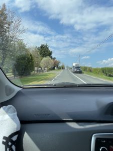
| View from the car (don’t worry – Val was driving) down the dead-straight R392 from Mullingar en route to Corlea. It’s like a Roman Road but isn’t. It was built on the track of the ancient Slighe Assail ceremonial route which eventually leads to the Hill of Tara. It’s not clear when the Slighe Assail was constructed but it was probably well over a thousand years ago. By the way local folklore has it that the Romans never came to Ireland because they were put off by the weather. Indeed the Graeco-Roman name for Ireland was Hibernia which is said to translate as “Land of winter” | The Corlea Visitor centre is right in the middle of the bogs, in the middle of nowhere. When you get out of the car you are struck by the silence, only punctuated by the birdsong. We heard the first cuckoo of 2022 from the car park. The late Charles Haughey, when he was Taoiseach, visited the site while the excavation of the bog road was underway. He deemed that it should be left in situ, which is why the visitor centre is here. It probably helped that his Finance Minister at the time came from a nearby town |
 |
 |
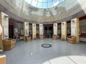
| Inside the visitor centre. It’s built in the shape of a Celtic Cross. This was the central atrium and the interior bit of preserved road is in an extension which runs off to the right. | Excavated bog, showing the stratified appearance, with human being for scale. Peat bogland, if left to its own devices, grows in depth by 1mm per year. |
 |
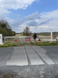 |
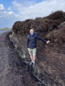
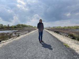
| Out in the bogland, with another human being for scale. OPW has built a walkway round the perimeter of part of the peat workings, on the trackbed of the old Bord na Móna narrow gauge railway. The massive extent of the workings, and the dramatic impact on the landscape, is clearly visible | As far as I could tell, this was the only bit of Bord na Móna railway still remaining, at the level crossing where it intersected the road. For anyone interested in these things, it ran on 915mm / 3ft gauge track |
 |
|
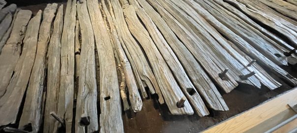
| Inside the visitor centre with the preserved, exposed 18m / 50ft section of the trackway. The recovered planks were soaked in a solution of polyethylene glycol then shipped off to Portsmouth to be freeze-dried (which preserves the wood structure) by the same team that restored the Mary Rose warship. They were then returned to Ireland and replaced exactly where they came from, but now exposed for inspection. The whole process took several years | |
Interactive map
(Elevations corrected at GPS Visualizer: Assign DEM elevation data to coordinates )
Max elevation: 58 m
Min elevation: 49 m
Total climbing: 52 m
Total descent: -52 m
Total time: 01:26:13
You can read earlier and later days’ blogs below
Previous day’s blog
Next day’s blog
Ireland home page
 Save as PDF