Ireland day 0205. Thursday 21 April 2022- Wicklow
| Today’s summary | Drove down to the National Botanic Gardens at Kilmacurragh in the morning then across to the coast near Wicklow Town. Clifftop walk to the lighthouses at Wicklow Head – most easterly point in Republic of Ireland | ||||
| Today’s weather | Bright, dry and sunny. Moderate easterly wind. About 13C | ||||
 |
 |
||||
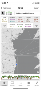
| Today’s overview location (The blue mark shows the location of our route) |
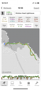
Close-up location (The green line shows where we walked) (Click button below to download GPX of today’s walk as recorded, or see interactive map at bottom with elevations corrected): Wicklow Head lighthouse from Glen Beach |
||||
Commentary
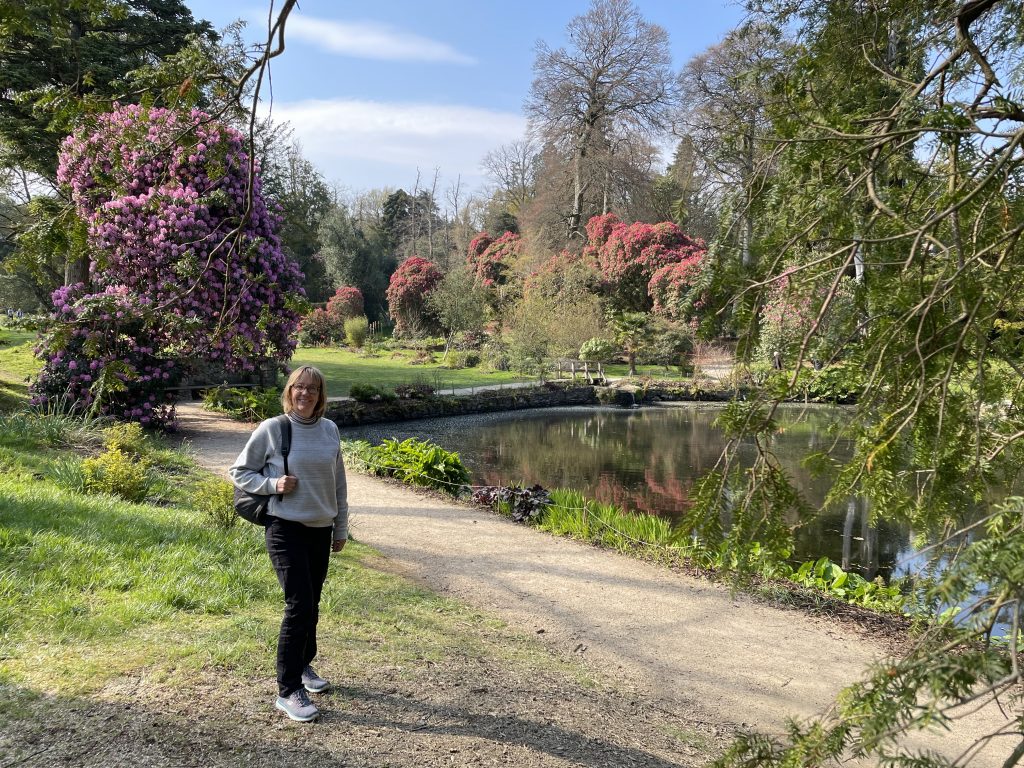
For the last few days, it feels like our activities in Ireland have been a bit circumscribed by travel, work and admin commitments. So when a free window appeared in our diaries today, we decided to make the best of the sunshine to jump in the car and go exploring. Our destination today was Wicklow – both in the county sense, and in the town sense. First up were the gardens at Kilmacurragh, just inland from the coast at Wicklow Town. The gardens today are run by the OPW and are an outpost of the National Botanic Gardens at Glasnevin in Dublin. The soil and climate are more favourable than back in Dublin, so a different range of plants grows there.
Historically, the gardens have had a bit of a chequered past. For almost the first thousand years of their existence, from seventh century, the lands were the site of a hermitage and then a monastery until Henry VIII’s dissolution in the 1530s. A hundred years later, the lands were granted to Thomas Acton in lieu of wages by Oliver Cromwell in recognition of his support in the murderous conquest of Ireland. The Acton family owned them until the 1940s when a combination of war and death duties forced them to abandon the site. But under their tenure, a huge collection of exotic plants had been amassed, and the Actons developed it as a de facto private botanic garden. After a period of dereliction, the land came into the ownership of the State in 1974 and finally was transferred to the OPW in 1996.
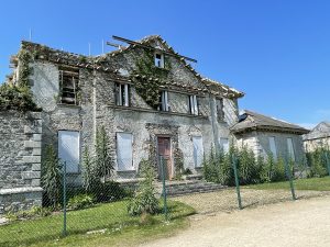
It’s a beautiful but slightly odd place. There’s a café (essential, obviously) but no other infrastructure. There is no information centre, no interpretive boards, not even a gatehouse for admissions. There’s just a paper note stuck to the door of the gents toilets to tell you that the gardens close at 5pm and if you are there after that you will be locked in. And once you are inside the grounds, you are struck initially by their beauty and interest, but then suddenly you round a corner and come across a huge ruined house right in the middle of it all, being held up by bits of wood and some metal scaffolding.
There’s quite a lot of history attached to the house, as it turns out – and you can read some of it in the captions to the photos below. But there’s a lot of public pressure to restore the house and turn it into a proper visitor centre. It would certainly solve the problems of both the dereliction and of the lack of proper entrance facilities. But of course it would come at a considerable cost. Something will have to be done with it, though, or else the elements will take matters into their own hands and it will simply collapse.
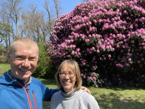
The gardens themselves are beautiful – and today with the rhododendrons at their very best against a glittering blue sky, they really was quite stunning. We had leisurely stroll around then found a quiet spot in a sunny glade to have our picnic lunch. It was very peaceful, with very little to disturb the tranquillity except the sigh of the wind in the trees and the almost-deafening birdsong, like a dawn chorus on steroids.
We enjoyed our stay there and before we knew it it was 4:30pm so we headed out, anxious not to find out what being locked in a botanic garden overnight would be like. But it was still bright and sunny and felt like it was far too early to go home. So instead we drove the few km east down to the coast at Wicklow town, and then on to the Glen Beach car park from where Google told me a path would lead out to Wicklow Head. On the way I took a wrong turn which meant that we drove right through the middle of Wicklow Town – and actually came out quite impressed. It was lively and seemed to have a genuine charm. We resolved to come back soon and have a full day there exploring.
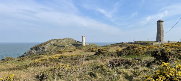
The walk to the headland is only about 2½km each way, but it’s really enjoyable. There was a cool wind and it was a bit hazy, but the path was dry and easy underfoot, and it felt like a proper coastal walk. It reminded me a lot of the Welsh coast path near St David’s, actually. Perhaps that’s not entirely coincidental though, as Wicklow Head is one of the closest points in Ireland to the Welsh mainland. There is a lighthouse at the end of Wicklow Head and, rather like the Kilmacullagh gardens, the place a bit odd. The first thing you notice is that the headland itself is signed as Private Property – but people seemed to be walking in and out of it at will, so we followed suit and took a brief peek at the forbidden land.
The second thing you notice is that there are actually two lighthouses. A “Front” tower (the white one in the picture at the top of this blog), and “Rear” lighthouse – the octagonal stone tower at the right of the picture. They were both built in the 18th century and two were put there so mariners could tell where they were – in particular so they didn’t mistakenly think they were at Hook Head to the south or Howth to the north – both of which look similar but which only have one lighthouse. As it happens, neither are operational as lighthouses now, as the “rear” lighthouse was partially destroyed by lightning in 1836, and it was discovered that they weren’t very effective anyway as they were frequently enshrouded in fog. So today, the new (single) lighthouse is situated further down the cliff, towards the sea and out of view from the headland itself. And the “rear” lighthouse has been bought by the Irish Landmark Trust and turned into a desirable self catering cottage – yours for a mere €322 a night off-season.
After a quick look round, we were both starting to get hungry, so we headed back along the cliff path again, admiring the thrift under our feet, ready to burst into flower at any moment, and drinking in the coconut balm of the heady gorse bushes in full bloom lining the path. Our quick run back to Malahide round the M50 was only briefly – but hastily – punctuated by a dash to the service station for petrol, when I noticed I had only 10km of fuel left in the tank. Luckily Val is a bit of a whizz with google maps so saved our bacon and found a petrol station with literally seconds to spare. (As a matter of interest, The Yaris seems pretty consistently to be getting about 5.6 litres /100km which is 50mpg in more familiar units, which isn’t bad going).
We were back at the flat by 7:30 and in next to no time, it seemed, Val had pulled together a delicious cashew nut risotto, which we are just about to enjoy now. Then I think we will be heading off for an early night to digest our dinner and reflect what had been a busy but altogether rewarding day.
Today’s photos (click to enlarge)
 |
 |
| The ruins of Kilmacurragh house, built in about 1700 by the Acton family. Its now dilapidating fast, having been ravaged by fires some time before the OPW took over the site in 1996. There’s an ongoing debate about what should happen the ruin – the OPW currently have to protect it from collapsing further but have no obligation to restore it. As usual, arguments about money are at the root of the disputes. In the meantime the magnificent building just crumbles before your eyes | The rhododendrons were pretty much at their best when we visited. The gardens at Kilmacurragh have the largest collection of Himalayan rhododendrons in Europe. |
 |
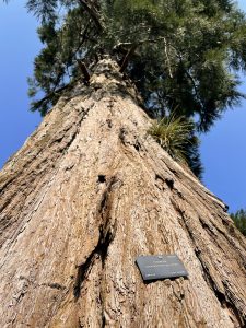 |
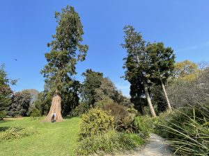
| More of those giant redwoods, Sequoiadendron giganteum. The one on the left was probably planted about 1850 | If you are a tree hugger, this is the view looking up from your hug |
 |
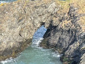 |
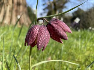
| Fritillaries growing in the grass verges. they are rare in the wild and I’ve never seen so many in one place before | On the coast path to Wicklow Head. Once you get south of Dublin, the coast line changes dramatically. The huge flat beaches of the northern areas around us are replaced by rocky headlands and cliffs. Much more spectacular but I do quite like the freedom of the big beaches. The rock here appeared to be a fascinating striated form of schist |
 |
|
| Lots of lovely decorative features down by the pond at Kilmacullagh. The pond was actually built as a fish pool for the monastery that was originally situated here from the seventh century until the dissolution of the monasteries by Henry VIII in the 1500s. Stone from the ruined abbey was used to build Kilmacullagh House, now itself falling into in disrepair | |
Interactive map
(Elevations corrected at GPS Visualizer: Assign DEM elevation data to coordinates )
Max elevation: 64 m
Min elevation: 1 m
Total climbing: 224 m
Total descent: -225 m
Total time: 01:20:17
You can read earlier and later days’ blogs below
Previous day’s blog
Next day’s blog
Ireland home page
 Save as PDF