Ireland day 0169. Wednesday 16 March 2022- SlieveFoye
| Today’s summary | Took advantage of a change in the weather for the better to drive up to Carlingford and climb Slieve Foye, highest peak in the Cooleys. Very enjoyable | ||||
| Today’s weather | Dry and bright all day. Hazy sun at first, full sun later. Light westerly wind, strong on the tops. About 8C | ||||
 |
 |
||||
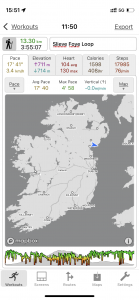
| Today’s overview location (The blue mark shows the location of my route) |
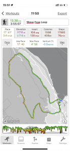
Close-up location (The green line shows where I walked) (Click button below to download GPX of today’s walk as recorded, or see interactive map at bottom with elevations corrected): Slieve Foye Carlingford |
||||
Commentary
The other day in this blog I was waxing lyrical about the virtues of living in Malahide and being able to get to both the coast and lovely parkland within five minutes walk of our front door. Well I should really have added “mountains” to that list of benefits, too. Because although the area along the east coast immediately around here is pretty flat, there are fine mountain ranges – with “proper” hills to explore, within just an hour’s drive. To the south are the Dublin and Wicklow mountains, with Lugnaquilla rising to a respectable 925m (3035ft). And to the north are the Cooley and Mourne mountains – albeit that the Mournes are in a different country (and, technically, not actually even in Europe).
Today I had planned to catch up on the washing and cleaning, and deal with some of the paperwork that has accumulated over the last few days. But as soon as I woke up and opened the blinds, I suddenly had a better idea. The sun was shining, the overnight rain had begun to dry up, and the wind had died right down. In fact it was altogether far too good a day to waste on paperwork.
So I leapt (that is an exaggeration for effect, by the way – I never leap anywhere before breakfast) out of bed and started thinking about where to go. The main decision was “North” or “South” and of course now we have a car, both are realistic prospects. Today I chose “North”, because very soon we will be spending a few days “South” and I didn’t want to overdose on Wicklow. I’ll explain more about that, by the way, in a future blog. Having elected to go north, I decided to head into the Cooleys once more. I like these hills, because they are a bit quieter than the Wicklow hills, being slightly off the beaten path, and on a good day they afford brilliant views, particularly to the south and east.
Once I had got my stuff together, I jumped into the car and headed off up the M1. I was in Carlingford in next to no time, and it seemed like it was only moments after finishing breakfast in Malahide that I was hiking out onto the wide open countryside high above the lough. I’d decided to aim for Slieve Foye, the highest point in the Cooleys, at 588m / 1932ft. It towers over Carlingford and makes a spectacular backdrop to the village. I’d devised a circular walk of about 13km which I thought would fill the afternoon nicely.
And what a fantastic day it was. We’ve had quite a lot of wind and rain lately, but overnight, there seems to have been a definite shift in the weather pattern. The cold south-easterly wind which has been blowing for the last couple of weeks now had veered* over to the west, and although it didn’t feel any warmer, the air cleared and the sun came out. Let’s hope this is the start of a more settled weather pattern for a bit. So as I climbed up on one of the Carlingford Loop Trails, heading for the bealach at the Golyin Pass, the views behind me over Carlingford Lough and to Northern Ireland really opened up spectacularly. Although we have been this way a few times before, this is the first time that the weather has been anything like this accommodating.
*I understand from sailing friends that when the wind moves clockwise to the west, it “veers” rather than “backs”. “Backing” is moving anti-clockwise. Well now you know.
The good thing about the Slieve Foye is that it is what I call a “no messing about” mountain. What I mean is that you start at sea level (the car park was at just 1metre above the sea) and climb straight up, with no false summits, and none of those awful undulations which cause you to lose half of the height you have just gained before you start on the next stage of the ascent. Once up at the Pass, the climb steepens and in parts its almost a rocky scramble as you head upwards – nothing difficult but enough to give you a definite sense that you are on a “proper” hike.
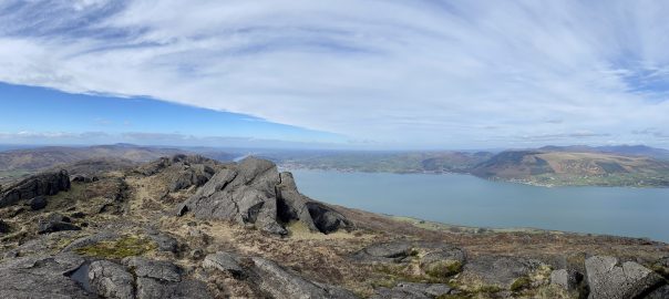
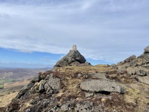
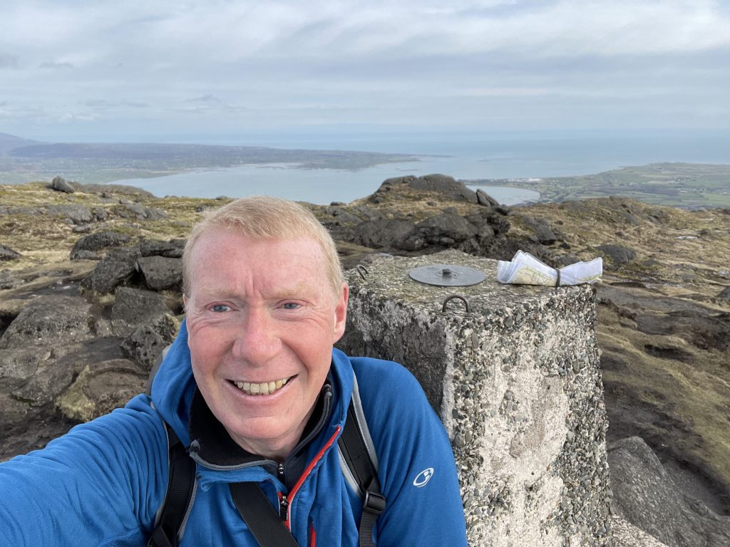
The top itself is adorned with a trig point and, today, gave the most spectacular views imaginable in all directions. You can see a panorama from the top, looking roughly north east, in the banner image of this blog. If you look closely, you might just be able to make out a small pimple at the far right hand side of the horizon. This is Slieve Donard, highest summit in Northern Ireland, at 850m / 2790ft. Looking the other way, to the north west, I could clearly see the Carnavaddy ridge that I explored in the pouring rain exactly a week ago. From this vantage point, and on a clear day like today, it all looked terribly simple and I can’t imagine what all the fuss was about!
Heading north from the top, the path pretty much disappears so you have to navigate carefully across the rocks and bog to reach the top of the Two Mile River valley, and the route down. There is the thinnest of tracks down the side of the stream, and it’s quite steep so you have to be a bit careful. But just like there is no messing on the way up, there isn’t on the way down, either. So you are back at the forestry road, and on another of the Carlingford Loop trails, very quickly. At this point, by the way, you rejoin the Tain Way – parts of which I walked when I did the Carnavaddy hike.
A stroke of luck – which you can read more about in the pictures below – meant that I didn’t have to follow the forestry road all the way back to Carlingford, but could make use of what I assume is a “new” (because it isn’t shown on any maps) path, running through fields and moorside parallel to, and below, the road.
I was quickly back in Carlingford, with just enough time to admire its colourful and charming streets – the whole place looked a bit like a Dulux advert I must say – before climbing back into the car and making the relatively short trip back to Malahide.
The walk came in at just over 13km / 8mi, and took about 4 hrs. So not an epic by any stretch of the imagination, but I thoroughly enjoyed every step. And I still simply can’t get over the fact that I was striding out into this beautiful wilderness not much more than an hour after finishing my second cup of tea in bed. Long may these happy discoveries continue.
Today’s photos (click to enlarge)
 |
 |
| On the way up, on one of the (many) Carlingford Loop trails. Slieve Foye is the summit in the background | Approaching the summit trig point, looking north west. The Carnavaddy range, which I was exploring last week in the rain, is in the background. An altogether completely different day today |
 |
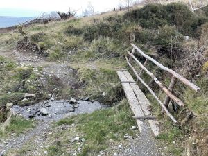 |
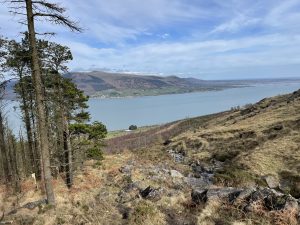
| Coming down Two Mile River to Carlingford Lough, looking over to Northern Ireland | The thin track down two Mile River meets a road at the bottom and I thought I would have to follow it for a rather tedious 4km walk back to Carlingford. But when I got to the road, I discovered a noticeboard with a map on it showing a path, running back to Carlingford parallel to the road but below it. The path, with the footbridge, is shown in the picture and it’s actually pretty decent. Much better than the road, anyway. It isn’t shown on any maps that I’ve ever seen, apart from the one on the noticeboard. |
 |
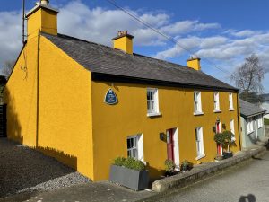 |
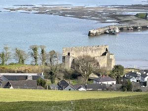
| Looking down into King Johns castle in Carlingford on the way back along the “new” path. We had a look round the (outside of) the castle when we visited on a rainy day in October last year. | Colourful Carlingford this evening. It’s a charming spot but a bit of a tourist honeypot |
 |
|
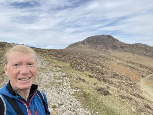
| On the top. The trig point is balanced somewhat precariously on the top of a big boulder, and it’s a bit of a scramble to get up to it. Someone had left a set of laminated maps behind – they were firmly secured under an iron eyelet, but I somehow doubt they will be back up to collect them. Behind me is Carlingford Lough, with the spit of land at Greenore in the centre right. You can take a ferry over to Greencastle, in Northern Ireland, on the other side of the lough from there. | |
Interactive map
(Elevations corrected at GPS Visualizer: Assign DEM elevation data to coordinates )
Max elevation: 580 m
Min elevation: 1 m
Total climbing: 780 m
Total descent: -780 m
Total time: 03:55:02
You can read earlier and later days’ blogs below
Previous day’s blog
Next day’s blog
Ireland home page
 Save as PDF