Ireland day 0131. Sunday 06 February 2022- Clontarf
| Today’s summary | Took the DART to Clontarf Rd then hiked with Dublin Walking Club out to Dollymount Strand on Bull Island. Then walked whole length of the island and caught bus back to Malahide via Sutton (for coffee) at the end | ||||
| Today’s weather | Bright and blustery. Brilliant sun but occasional sharp showers. Strong southwesterly wind. About 8C | ||||
 |
 |
||||
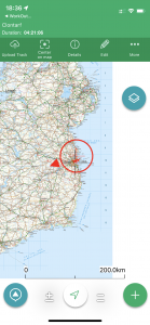
| Today’s overview location (the red cross in a circle shows where Val and I are at the moment) |
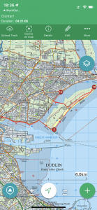
Close-up location (Click button below to download GPX of today’s walk as recorded, or see interactive map at bottom with elevations corrected): Clontarf DWC |
||||
Commentary
There’s quite a lot I could write about today’s outing, but I realise I have already said most of it before. The day was framed around another outing with the Dublin Walking Club, which was billed as an exploration of the section of coast between Clontarf Road DART station and Dollymount Strand. I was especially interested to go because I wanted to see what Clontarf today looks like – after having read all about Brian Ború and Sitric Silkenbeard’s travails on this spot a thousand years ago. I was also keen to see for myself Dollymount Strand as I had heard a lot about it but didn’t actually know where it was.
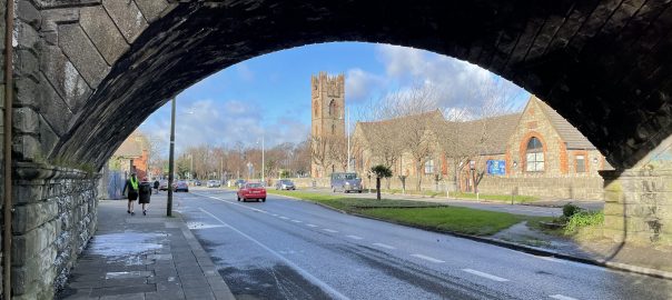
The walk didn’t start till 12 and Clontarf Rd is only 20 minutes from here in the DART, so I could have a leisurely breakfast and make a start on Ulysses (I didn’t get very far unfortunately – I am still on the Introduction). Once we got going on the walk itself, the sky cleared and yet again I was fortunate enough to enjoy a day of mostly vivid blue skies and bright sun while I was out with the club. By the way – the bridge featured in the image at the top of this blog carries the DART rail line and is of importance to rail architects as it is a good example of a “skew” bridge – in other words it is not perpendicular to the road and so the arches are not perpendicular to the track bed.
The DART station is right on the Clontarf Road and is located in what looks like a prosperous and well established suburb of Dublin. It doesn’t take long to walk down to Clontarf itself but if you were expecting to see a dramatic battle-ravaged landscape dotted with Viking helmets and discarded spears, you would be sadly disappointed. Today, it’s a fairly anonymous but pleasant seaside town, with a nice view over Dublin Bay and an attractive coastal park. There are a couple of interpretive information boards, and “Battle of Clontarf Heritage Trail” which help you to imagine what the place must have been like all those years ago.
One thing I did learn was that the Viking aggressors were not a united bunch – Dublin was held by an uneasy alliance between Norwegian and Danish invaders at the time of Clontarf, and aside from the battles with the native Irish, they were always at war with themselves. The 150-or so kingdoms of Ireland, of which Brian Ború claimed to be supreme leader, were also continuously involved in internecine strife. So Ireland in the 1000’s must indeed have been a turbulent place and the battle of Clontarf was probably just one particularly bloody episode in this endlessly violent period. Definitely a time when you wouldn’t want to stick your head above the parapet, for fear of getting it cut off.
We soon made it to the wooden bridge leading out to the Bull Wall and having crossed over the inlet I realised I was on familiar territory – this was in fact North Bull Island, which Val and I had visited just before Christmas. Once we had crossed the width of the island and arrived at the beach I was told that this – the eastern beach on Bull Island – was in fact Dollymount Strand. So this mysterious spot wasn’t in fact anywhere new – I had already been there before (actually twice before – once with Val and once briefly back in October when I came down on my bike while Val was away).
Despite the relative familiarity, we set off up the Strand and this time we walked the full 5km of the island, right to the northern tip. This was definitely unexplored territory, and it was uplifting and invigorating. At the right time of year, and in the right weather, you can often see seals lazing on the beach up there. Today the conditions weren’t right, or they were away on holiday, so I can’t report any phocine encounters. A good reason to come back, though, I’d say. I especially enjoyed the walk back down from the tip to the Causeway Road through the dunes, with the brilliant low level sun catching the sea and making it shine like burnished silver.
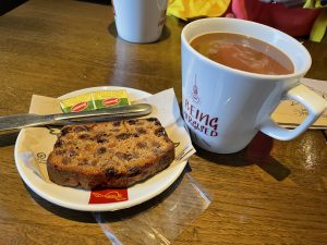
Once back on the mainland, we hopped on a convenient no 6 bus and headed for a café in nearby Sutton. After a blowy few hours on the beach, a large hot coffee and a slice of fruitcake definitely felt well deserved. From there it was a short walk to Sutton station where a conveniently waiting no 102 had me back in Malahide in next to no time.
So the main surprise from today was finding out that I already knew what I thought I didn’t know. But I thoroughly enjoyed the day out and felt extremely lucky to have had, once again, a bright sunny day for my explorations of Ireland.
Today’s photos (click to enlarge)
 |
 |
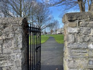
| Just outside Clontarf Rd is Bram Stoker park. It’s actually a really nice green space, despite the rather ominous sounding name | Out on Dollymount Strand. I had heard of this Strand as it’s popular with swimmers and sun-seekers in the summer. But I hadn’t actually twigged that the beach is actually on Bull Island. In fact the whole of the eastern beach is technically Dollymount Strand and it’s 5km long. We walked the whole length of it today |
 |
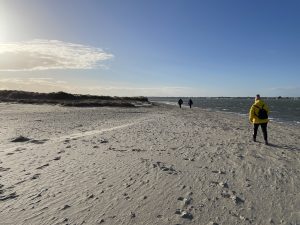 |
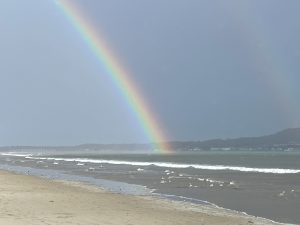
| We were struck by one of the “short, sharp showers” that TV presenters love to throw into their weather forecasts. It was over almost as soon as we had got our waterproofs on, but it left a magnificent rainbow hanging over Howth once the sun came out again | At the very northern end of the strand. Even on a sunny Sunday, it was pretty deserted, though the strong wind and downbeat weather forecast may have put a lot of potential visitors off. |
 |
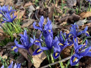 |
| Felt particularly well deserved in the café in Sutton at the end. | There was a magnificent display of miniature irises in Fairview Park at the start of the walk. I never knew they flowered so early! |
 |
|
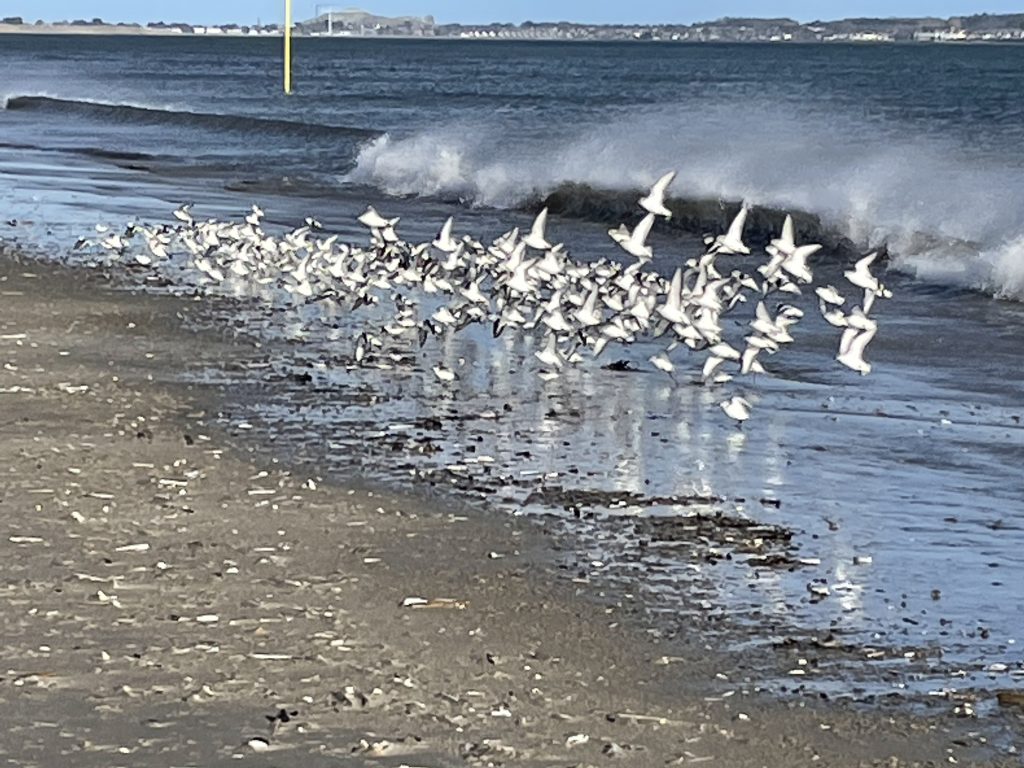
| This flock of sanderlings preceded us up the beach. The landed about 50 metres in front of us and started grazing on the shoreline then took off in synchrony when we got too close. A really spectacular sight | |
Interactive map
(Elevations corrected at GPS Visualizer: Assign DEM elevation data to coordinates )
Max elevation: 14 m
Min elevation: 0 m
Total climbing: 162 m
Total descent: -161 m
Total time: 04:21:06
You can read earlier and later days’ blogs below
Previous day’s blog
Next day’s blog
Ireland home page
 Save as PDF