Ireland day 0102. Saturday 08 January 2022- Coastal
| Today’s summary | |Followed a similar route down the coast as yesterday, but instead of heading off for Portmarnock, we kept on going down the coast all the way to Howth. Got the DART train back. | ||||
| Today’s weather | Cool bright and dry after overnight rain. Moderate north westerly breeze. About 6C | ||||
 |
 |
||||
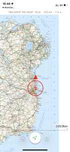
| Today’s overview location (the red cross in a circle shows where Val and I are at the moment) |
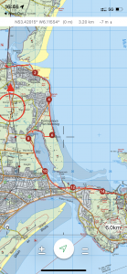
Close-up location (Click link below to download a GPX of the walk and also see interactive map at bottom): Coast walk to Howth |
||||
Commentary
When you settle in a new place, initially, every day is a bit of an adventure – a voyage of discovery, while you explore your new environment and deal with the inevitable snags that come up. But after a while, you get past that and begin to settle into a routine. We both today realised that we were reaching that point in Malahide – so we are starting to think in slightly more concrete terms about where we might go next. Wicklow maybe, or perhaps the west coast? But it’s early days yet and we certainly won’t be going anywhere in a hurry. Though it’s nice to start daydreaming.
Along the same lines, we have explored quite a lot of the coast between Howth and Drogheda now, so we are focussing more of our time on Dublin, while we are in the area, as there is simply so much to see there. And today we starting planning our visits for next week, already. But back to today. Yesterday had been an enjoyable – if cold – walk down the coast to Portmarnock. But we both felt we would have liked to have gone on a bit further, if it hadn’t been so cold and if we hadn’t set off so late. We decided to remedy that today by getting up a bit earlier and retracing our footsteps to the Velvet Strand, and then on through the dunes and marshes to the point where the road branches off to the station at Portmarnock Bridge.
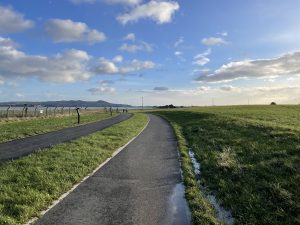
At that point, we ventured into slightly newer territory and joined the greenway which leads towards Baldoyle, Sutton and Howth – our eventual destination for today. The greenway is excellent though a bit of a misnomer as it’s anything but green. Rather, it’s a well engineered tarmacked lane, ideal for bikes and buggies but a bit hard on the feet for any distance of walking. And as you’ll see from the phots at the bottom, it is of limited usefulness at the moment as it doesn’t really connect anywhere to anywhere else.
Eventually our meanderings, which were uneventful though enjoyable – took us to Sutton and the beach. Most of the beach was actually under water when we got there to take a look – but we could tell it very much conformed to the east coast vernacular – fine, gently sloping sand, backed by dunes and marram grass. And, of course, very busy, with this being a sunny Saturday when the tide was in. Goodness knows what it’s like in the summer.
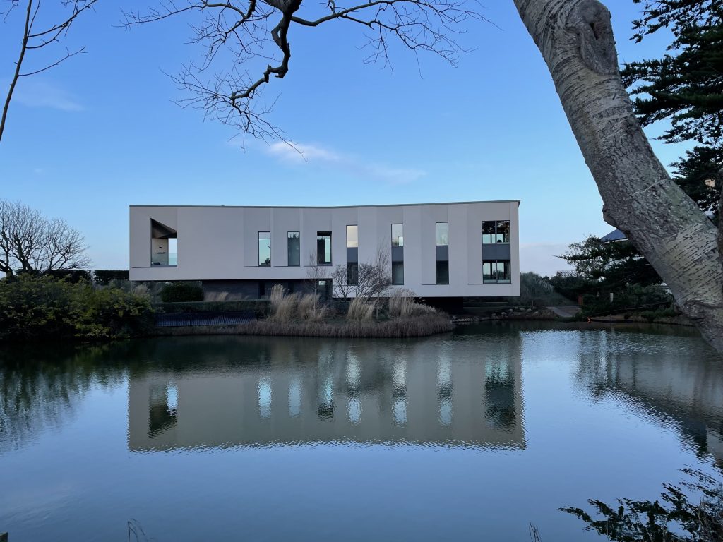
There are also some very impressive houses on the Sutton tombolo – in many ways it’s similar in location and style to Sandbanks in Dorset, UK. One in particular caught our attention – Lake House – which you can see and read about in the photos below.
Oh- and that word tombolo. It means “a fine spit of sandy land which connects the mainland to an outlying outcrop” – in this case Baldoyle to the Howth peninsula. Howth was in fact almost certainly an island until the early part of the first millennium AD, but gradually the same coastal erosion, drift and deposition which is eating away at Rogerstown and steadily building up Bull Island, deposited the isthmus of sand at Sutton. It eventually became dry land sufficient in area to build the town of Sutton on, and firmly to connect Howth Island to the mainland. There are many other examples of tombolos around the world, and some particularly fine ones in the Shetland Isles.
From Sutton it was only a short walk further to the Howth railway station (which is cunningly disguised as a pub called the Bloody Stream – and yes it is actually a pub as well as a station; only in Ireland!), from where a conveniently waiting DART train took us speeding back to Malahide, with just a quick change at Howth Junction. And the good news tonight is that, after a wobble a few weeks ago, we have found a shop that sells fish fingers. What a relief! So no prizes for guessing what’s on the menu for dinner tonight.
Today’s photos (click to enlarge)
 |
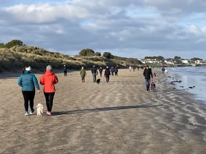 |
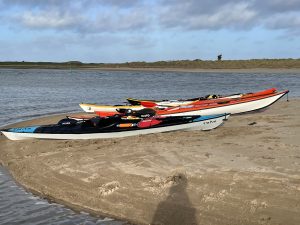
| The canoeists were actually pitched up on the beach behind us, enjoying sandwiches and presumably taking a break from battling the rapidly flowing tide in the Broadmeadow estuary | On the Velvet Strand just below Portmarnock. Everyone and their dog was out today – presumably because it was a sunny Saturday, and the beach appeared more crowded than normal because the tide was in, compressing the available walking space |
 |
 |
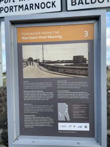
| If you get your magnifying glass out you will be able to read about this Tide Mill on the estuary of the Sluice River, between Portmarnock and Sutton. It used tidal flows in the estuary to drive a grinding wheel – sometimes that was apparently done in coastal rivers that lacked a consistent or powerful enough flow of river water – as opposed to incoming and outflowing tidal water – to drive a conventional waterwheel. An early and practical example of tidal power generation – and given that we calculated a few weeks ago that the Broadmeadow probably generates around two megawatts, it’s actually quite surprising that it wasn’t done more often. | Midway down our walk |
 |
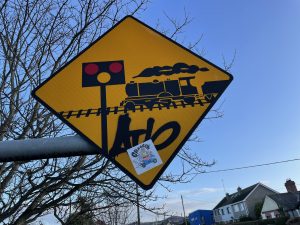 |
| I call this the road to nowhere. It’s a fabulous “greenway” (i.e. a car-free lane used by pedestrians and bikes) which connects nowhere at the north end to nowhere at the south. It actually runs parallel to the R106 between Portmarnock and Baldoyle and I have a feeling that it was anticipated that at some point it might form part of a longer Greenway running all the way from North Bull Wall to Donabate (if the bridge over the Broadmeadow is ever completed). But for the moment it starts and finishes nowhere in particular, and accessing either end on foot or by bike involves negotiating a series of busy roads | An internationally recognised sign for a level-crossing, but I wonder how many people under the age of about 50 know what the thing on wheels with smoke coming out of the top actually is? |
 |
|
| Lake House, Sutton. An absolutely magnificent-looking property with a freshwater lake at the front and direct access to the beach from the back. Designed in about 2008 by Aughey O’Flaherty Architects, it is one of Sutton’s premier properties (do I sound like an estate agent?). But it always seems to be changing hands and it always sells for way lower than the initial valuation. So perhaps it’s one of those houses that is nice to look at but not so nice to live in. Or maybe that’s just sour grapes. | |
Interactive map:
(GPS elevations replaced with DEM via
GPS Visualizer: Assign DEM elevation data to coordinates)
Max elevation: 14 m
Min elevation: -1 m
Total climbing: 172 m
Total descent: -177 m
Total time: 03:47:41
You can read earlier and later days’ blogs below
Previous day’s blog
Next day’s blog
Ireland home page
 Save as PDF