Ireland day 0271. Sunday 26 June 2022- Dollymount
| Today’s summary | Joined the Dublin Walking Club for a short walk from Clontarf Road DART to Dollymount on Bull Island, then returned to Killester via St Anne’s Park, to catch the H2 bus back to Malahide | ||||
| Today’s weather | Cool, bright and windy with occasional very hard downpours of rain. Strong to gale force southerly wind. Appx 16C | ||||
 |
 |
||||
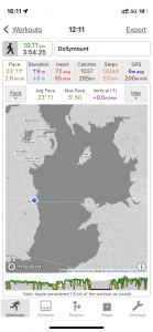
| Today’s overview location (The blue mark shows the location of our route) |
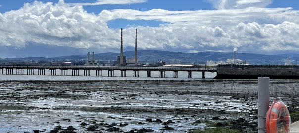
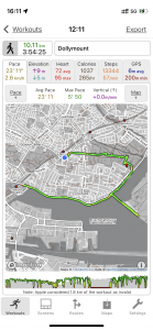
Close-up location (The green line shows where we walked) (Click button below to download GPX of today’s walk as recorded, or see interactive map at bottom with elevations corrected): Dollymount and St Annes from Clontarf |
||||
Commentary
I’d been down in the Clontarf / Dollymount area only a couple of days ago so it might seem odd that I decided to go back there again today. But the reason was simple. The Dublin Walking Club were organising a short social walk from Clontarf Road DART station out to Dollymount this afternoon and I decided to join them. Although it’s nice to visit the same, interesting, spots again, I like joining group walks like this at least as much for the opportunity to meet people and chat as to see the scenery. Especially while Val is away I think I would find it all too easy to sink into a solitary existence if I didn’t make a positive effort to go out and meet people.
And today’s walk didn’t disappoint in that respect. Although it’s only a week since I last met many of the walkers, there always seems to be such a lot to catch up on here in Ireland. Everything from the weather, wedding protocol, wild flower identification apps and the merits of dental implants needed to be discussed. Only politics is firmly off the agenda. So the time passed quickly but by mid afternoon I was beginning to feel drained by the chat so as the others made their way to the nearest pub to continue their discussions over a pint of Guinness, I made my excuses and headed over to nearby St Anne’s park to have a quick look round and to get a cup of coffee.
Val and I have been to St Anne’s Park a couple of times already and I am sure I have written about it in this blog before, too. But I still felt I didn’t know it very well, and as the second-largest park in Dublin, I thought I ought to go and pay a more thorough visit.
The park is indeed huge – but my ambitions to see it all were a bit cut short by a rapid deterioration in the weather which saw me sheltering under a tree to avoid getting soaked in a particularly torrential downpour, and wishing I had gone with the others to the pub. Still, I did manage to have a look around the Red Stables – built when the whole estate was owned by the Guinness (Lord Ardilaun) family – and today an arts venue, coffee shop and site of a farmers market on Saturdays. It’s a pleasant open courtyard enclosed by attractive red-brick stables buildings, although they must have been gigantic horses as the buildings were two or three storeys high. Perhaps the Guinnesses rode giraffes. Anyway, today it was thronging with visitors , enjoying the café atmosphere – or at least it was before it started pouring down with rain.
Once the rain stopped I decided to cut my losses and head over to nearby Killester to catch the H2 bus back to Malahide. I could have got a DART – which would have been much quicker – but decided against it. There was an event on in Malahide castle this evening (I’m not sure what it was through, as the main concert season finished yesterday) and the DART was likely to be mobbed with exuberant fans of whatever the event was. I thought the bus would be much quieter – it was – and anyway I like sitting on the top deck watching the view of the coast as the wheels on the bus go round and round all day long. Or so it seems.
Today’s photos (click to enlarge)
 |
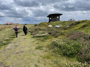 |
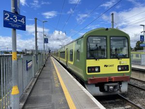
| The delightful DART at Clontarf Road station this morning. I should have explained in case anyone was wondering – “DART” is “Dublin Area Rapid Transport”. It was introduced in 1984 and essentially runs a single route up the east coast, from Malahide to Greystones, with a branch line from Donaghmede to Howth. The network is 53km / 32mi and it carries (pre-pandemic) 20 million passengers per year. There are plans in place to extend it north to Drogheda and also out to the west of Dublin | Heading out onto Bull Island, with one of the numerous art deco shelters on the embankment to the right. They were designed by Herbert George Simms and built in the 1930s and 50s |
 |
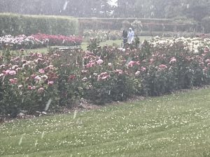 |
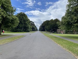
| The grand avenue in St Anne’s Park. This used to be the main approach to St Anne’s House, the mansion built by the Guinness family in 1837. In about 1870 Arthur Guinness, later Lord Ardilaun, planted the striking avenue of evergreen oak trees (quercus ilex) alongside the avenue to act as a wind break. they are just coming into their own now, 150 years later. Sadly St Anne’s house wasn’t so long lived. The Guinness family sold the estate to Dublin corporation in 1939. Sadly, during the “Emergency” (AKA second world war), the house was used as a store of equipment for the Irish Defence Force and it caught fire in 1943 and was gutted. The ruins were demolished (a real shame) in 1968 and now all that remains of the fine mansion is a small mound of earth at the eastern end of the grand avenue | In the rose garden. Barely visible through the torrent of rain that decided to deposit itself on the park (and me) at that very moment. Apparently it is internationally renowned and there is a rose show here every July |
 |
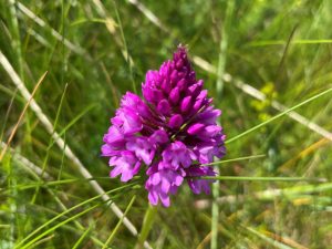 |
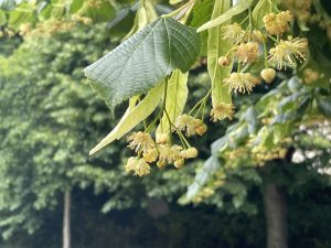
| Lime trees (Tilia cordata) just coming into flower. They have a very pleasant sweet smell, which seems a bit incongruous coming from such a robust looking tree | Beautiful orchid in flower along the Bull Island embankment. I’m pretty sure it’s a Pyramidal orchid (Anacamptis pyramidalis) and there were literally hundreds of them growing at this spot |
 |
|
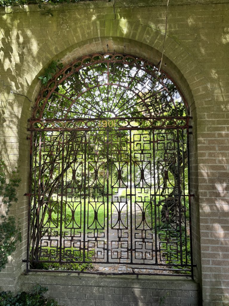
| There is a nice walled garden within St Anne’s park but you can only peer in at it through locked wrought iron gates. It seems to be a shame that it isn’t open to the public as it looked quite nice inside. Maybe it is open from time to time, just not today when I was visiting | |
Interactive map
(Elevations corrected at GPS Visualizer: Assign DEM elevation data to coordinates )
Max elevation: 27 m
Min elevation: 0 m
Total climbing: 150 m
Total descent: -131 m
Total time: 03:54:11
You can read earlier and later days’ blogs below
Previous day’s blog
Next day’s blog
Ireland home page
 Save as PDF