Ireland day 0268. Thursday 23 June 2022- Parks
| Today’s summary | Walked from Malahide to Dublin via as much parkland, beach and grassland as possible. Managed to avoid roads for about 80% of the route. Nice warm day, lots to see, very enjoyable | ||||
| Today’s weather | Mild, dry and with long sunny spells. No rain and very little wind except southerly breeze on the coast. About 19C | ||||
 |
 |
||||
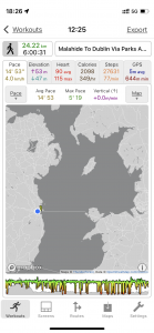
| Today’s overview location (The blue mark shows the location of my route) |
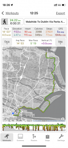
Close-up location (The green line shows where I walked) (Click button below to download GPX of today’s walk as recorded, or see interactive map at bottom with elevations corrected): Malahide to Dublin via parks and coast |
||||
Commentary
Before coming to Ireland, I used to enjoy planning urban walks – particularly in and around London – to see if I could string together a decent walk without too much tarmac, and maximising the use of parks and public spaces. I thought I would have go at doing the same today here, while the weather is decent and there’s no risk of running out of daylight in the evening. Since we live on the outskirts of Dublin, in Malahide, I thought an obvious thing to try would be to see if I could pull together a decent walk from our flat to the centre of Dublin, without having to include too much road-walking. I expected the challenge to be doubly difficult because of the lack of public rights of way in ireland – something which I have gone one about at length in previous blogs.
Funnily enough, as it turned out, I shouldn’t have worried. I did manage to create a good – and reasonably direct – route which linked together parks, green spaces and even a bit of beach walking all the way from Malahide to the river Liffey near Connolly station. I’d walked most of the bits on previous occasions but had never thought to link them all up. Today gave me the excuse to do just that.
So I set off late this morning, after faffing around with a few admin chores, doing the washing, and getting a packed lunch together. The first leg of my journey took me through Malahide castle demesne – which was looking splendid in anticipation of the arrival of Dermot Kennedy for his concert tomorrow night. Then on up and over Paddy’s Hill to Portmarnock – a curious town in that it doesn’t really have a centre. Rather it’s a sort of amorphous suburb which has grown up in bits and pieces over the years, especially since the opening of the railway station in 1844. It’s a nice spot though, with some rather fine houses.
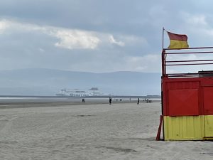
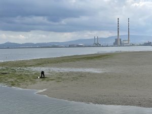
Just beyond Portmarnock, I briefly hit the coast then headed inland through the Baldoyle Racecourse Park, Seagrange Park (which was completely new to me) and finishing up near the Bayside Dart station. It was a short walk from there down to the greenway alongside the Dublin Road, which runs along the coast to Sutton Cross. This was one of the longest stretches of tarmac, actually, so I broke off as soon as I could and walked over the causeway to Bull Island, then down the beach to Dollymount Strand. It’s a nice spot though rather seaweedy today so quite challenging on the nostrils.
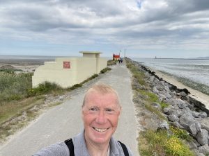
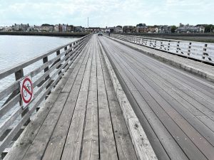
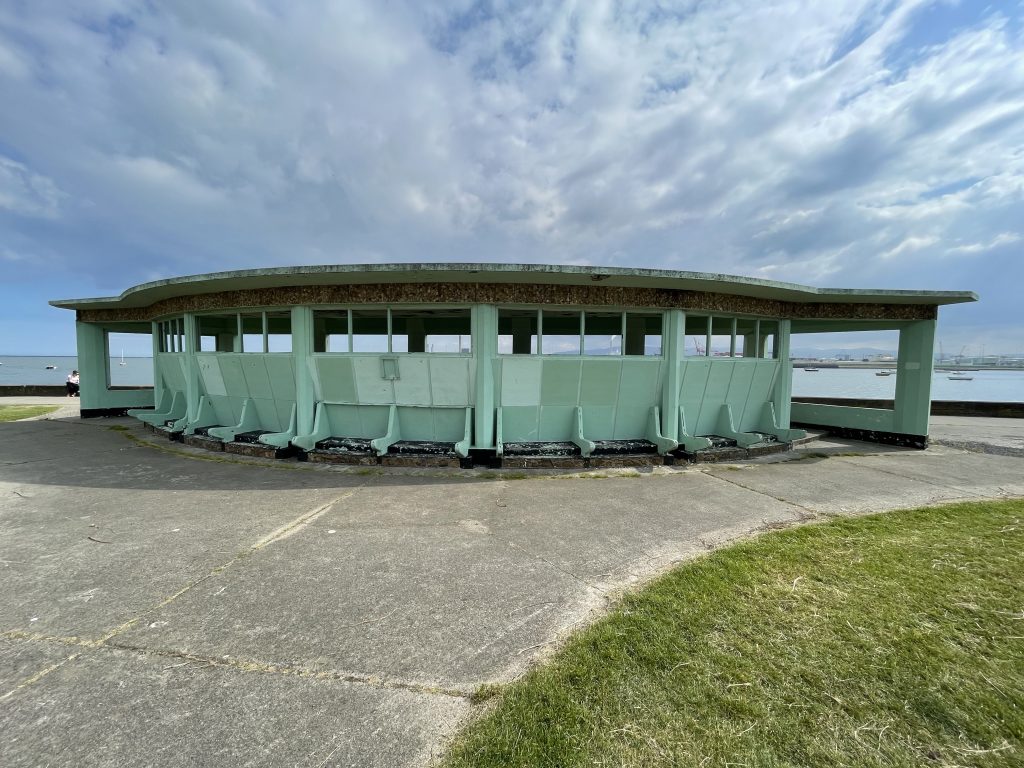
By this stage it was 3pm and I was starving, so I sought out one of Herbert George Simms’ art deco shelters along the Bull Wall (see below) and paused briefly (well about 45 minutes actually) to have lunch. After lunch I returned to the mainland over the Wooden Bridge, then found that there’s a narrow grassy park running alongside the road and which stretches the full length – some 5km / 3mi – of Clontarf Promenade. It makes for easy comfortable walking with lots to see – from the art deco architecture to the interpretive plaques describing the battle of Clontarf 1008 years ago in great and completely confusing detail.
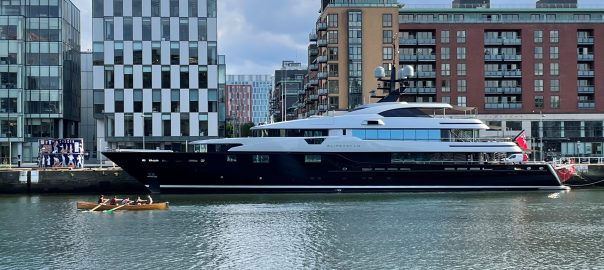
At the end of the promenade, there was another brief section through Fairview Park that was new to me, and then I was quickly in the East Wall suburb of Inner Dublin. From there, it was only a hop, skip and a jump – not literally you understand – down to the Liffey near the EPIC centre. Everything from there on was completely familiar – except for the massive superyacht “Slipstream” which was anchored on the opposite side of the Liffey, almost opposite the “Jeanie Johnston” emigration barque.
I was surprised that the Liffey would be deep enough at low tide to allow safe anchorage of such a big vessel but clearly the captain must have known what they were doing. Anyway it looked lovely and I believe it belongs to the Canadian – Australian fast food magnate Jack Cowin. You will be glad to know that you can rent it “from” €336,000 per week. A great option for Liverpudlians heading to Dublin for a stag weekend, I should have thought.
Anyway, I’ll leave you with that image in your mind, as I’m hungry yet again so need to get cooking. I will be finishing off the rest of Val’s delicious aubergine satay tonight, then it’s Ambrosia creamed rice pudding with half-price SuperValu apple pie afterwards. I bet they’re not having that on the superyacht.
Today’s photos (click to enlarge)
 |
 |
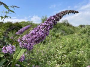
| Buddleia in full bloom in Baldoyle Racecourse park. I know they are a bit of an invasive weed, but I actually quite like them. They smell nice and attract butterflies (though there weren’t any around today). The most common species – which is what this one is – is Buddleia davidii and it originated from China | On Dollymount Strand on Bull Island. It’s a popular swimming spot but today the tide was right out and the exposed mudflats were covered in seaweed and rather smelly. Not a particularly attractive proposition |
 |
 |
| Walking back down the North Bull Wall in towards Clontarf. Bull Island formed over the course of a century in the lee of the wall, which was completed in 1825 on the recommendation of William “Mutiny on the Bounty” Bligh | Digging for something – presumably lugworms – on a mud flat off the Wooden Bridge leading to the North Bull Wall. By this point the tide had come in so the digger was technically on an island which was dwindling in size rapidly. I assume that he knew what he was doing as he had disappeared – hopefully to dry land not under water – when I looked back a few minutes later |
 |
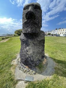 |
| The Wooden Bridge, originally built in 1819 to allow materials to be carried from the shore to the site of the Bull Wall construction | An Easter island “Moai” Statue on promenade. It’s a replica, though it was carved by an Easter Islander from Easter island volcanic rock. It was donated by the Chilean president in 2004 – apparently he had been on a trade mission to Dublin earlier the previous year and had enjoyed the craic in Temple Bar so much that he gifted this in grateful thanks. |
 |
|
| There are dozens of art deco structures along the Bull Wall and Clontarf Promenade. Wind shelters, bathing huts, tea rooms and miniature lighthouses, They were all designed by Dublin Corporation Chief housing Architect, Herbert George Simms in the 1930s and 1950s. They are all pretty striking though sadly in some of them, the pre-cast reinforced concrete is showing signs of wear and tear. This is a particularly striking wind-shelter near Clontarf Pier. It makes an ideal spot to linger and wonder how the view must have changed in the 1008 years since Brian Ború and Sitric Silkenbeard crossed swords on this spot in 1014 | |
Interactive map
(Elevations corrected at GPS Visualizer: Assign DEM elevation data to coordinates )
Max elevation: 50 m
Min elevation: -0 m
Total climbing: 212 m
Total descent: -202 m
Total time: 06:00:29
You can read earlier and later days’ blogs below
Previous day’s blog
Next day’s blog
Ireland home page
 Save as PDF