Ireland day 0262. Friday 17 June 2022- WrensNest
| Today’s summary | Took the train and bus in to Dublin to try and walk up the Liffey from Waterstown Park to reach the Wren’s Nest weir. Had got part way there last weekend with the walking club, but we stopped when the path was blocked by a fallen tree. Got through OK this time, but was disappointed not to see a kingfisher. Didn’t hang around at the weir, as it felt a bit isolated | ||||
| Today’s weather | Overcast and drizzly. Some rain in the afternoon. Moderate westerly wind. About 19C | ||||
 |
 |
||||
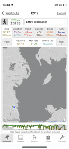
| Today’s overview location (The blue mark shows the location of my route) |
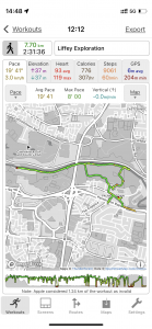
Close-up location (The green line shows where I walked) (Click button below to download GPX of today’s walk as recorded, or see interactive map at bottom with elevations corrected): Wrens Nest weir |
||||
Commentary
I hate leaving loose ends and I must admit I felt that a fairly major one was left last weekend. I had been out with the the walking club and on Sunday we tried to walk on an old footpath up the south bank of the Liffey, under the M50 viaduct, to the Wren’s Nest Weir. You access the path from Palmerstown, via the Waterstown Park, and last time we had got thwarted by a fallen tree blocking the path. I was determined to go back and see if I could get through the blockage and reach the weir. Also, on Sunday one of our group had spotted a kingfisher – while I had missed it. So I wanted to see if I would have any better luck today.
The first part of the day followed a familiar pattern. A quick video call with friends, then a bit of admin in the flat, and I was away by 11. A swift train and bus ride into Dublin and then out again to the western outskirts (I am getting good at this now) saw me back at the Palmerstown House pub by just after noon. As I knew my way through Waterstown Park from our visit last weekend, I was quickly at the start of the riverside path, under the M50 motorway, and ready to start my upstream exploration.
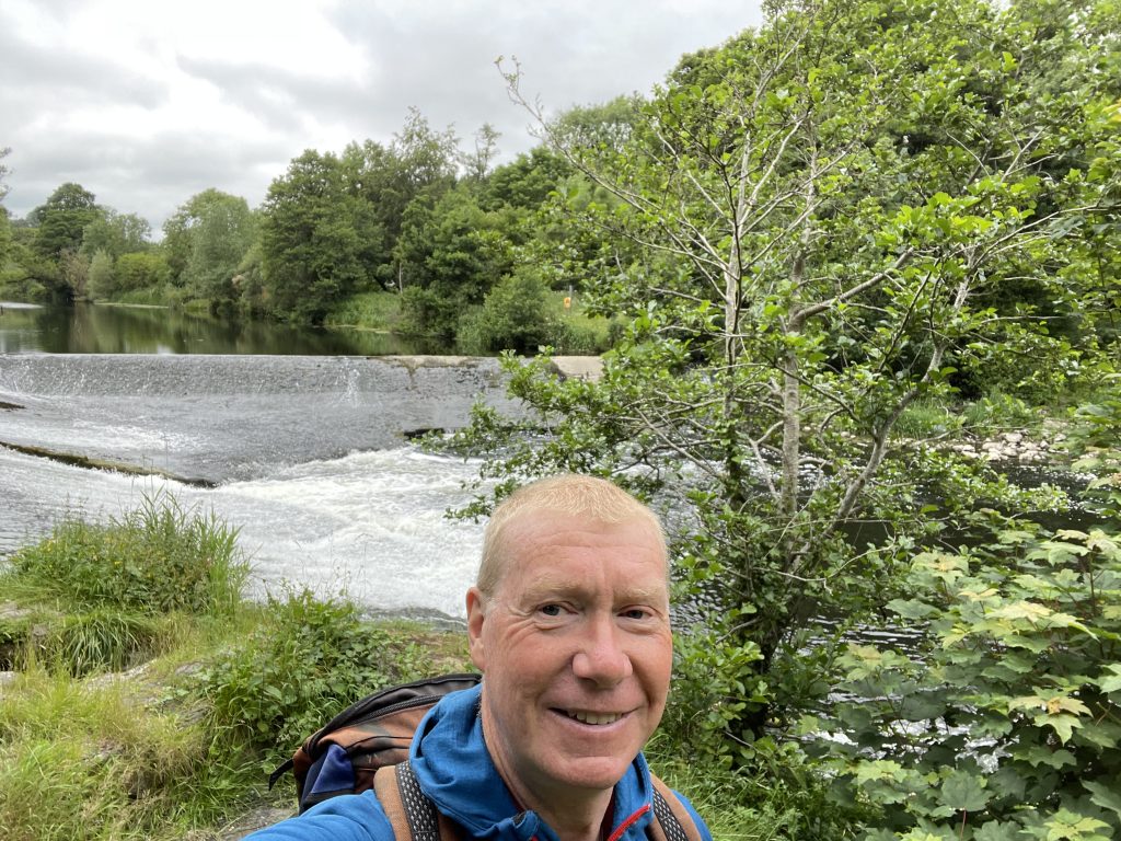
As I was on my own this time, rather than in a larger group, I was able to speed along through the undergrowth much more quickly today, so I seemed to be at the fallen tree in only a matter of minutes. I managed to clamber over the tangle of branches without too much trouble, and regained the path on the other side. Another ten minutes through the undergrowth and suddenly the path opened out onto a small platform – and the weir was right ahead of me.
It would be quite a charming spot if it wasn’t for the litter, graffiti and mess that seemed to have accumulated there. So I didn’t feel inclined to hang around to see if the elusive kingfisher would put in an appearance (it didn’t). Plus the fact that it felt a bit isolated up there and the path was a dead end, surrounded on three sides by water, meaning that there was no way out except back the way I had come. So I turned round as soon as I had taken a few photos, and hot-footed it (in so far as you can hot-foot anything when the path is as overgrown as it was today) back to the edge of Waterstown Park, under the motorway bridge.
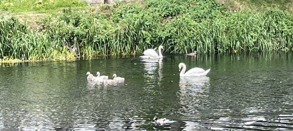
Once back in the more pleasant surroundings of the park, I decided that I was pleased that I had made it as far as the weir – it was definitely worth seeing. But disappointed not to spot one of the kingfishers. And I have to admit I didn’t like the uncomfortable sense of isolation on the path, so although it was interesting, I don’t think I’ll be rushing back. Then, as I was reflecting on my expedition, a couple of swans floated by, with a brood of four cygnets. The first I’ve seen this year, and a really cheering sight.
But one of the interesting features of the path is that it runs alongside a mill race – a channel of water that is diverted off the Liffey at the Wren’s nest weir. Nobody seems really to know what it was for, except that it was used to power various “mills” located downstream, along its banks. But as I walked back down the Liffey through the park, a possible explanation – with a bit of research – became apparent.
Towards the eastern edge of the park, you can see a big rusting bridge spanning the Liffey. This is the Farmleigh Bridge (sometimes known as the Silver bridge, on account of its colour, before it went rusty) and nowadays it is disused. But it turns out that the bridge was probably built around the year 1880, and it was definitely built by the Guinness family, who owned the Farmleigh estate – which is right opposite Waterstown Park, on the opposite side of the river – at the time. The curious thing is that it wasn’t really built to take traffic, but actually to carry water pipes and electricity cables over the river and up to Farmleigh House itself. Some sources say that the electricity was generated at various hydro mills in the Liffey valley, and I did wonder if the mill race may have been the source of the water supply. It makes a plausible story, though it might just be a case of me adding two and two and making five.
Oh and the other interesting thing about the bridge is that it leads straight into a hillside on the north bank, where there is an intriguing tunnel portal. Nobody really seems to know if it is a real tunnel or just a folly, but some sources say there is a – now collapsed – passageway leading underground from the bridge right up to Farmleigh house. There is a campaign afoot to get the bridge reopened – let’s hope it’s successful, and that any remediations are extended to include an investigation of the tunnel as well.
By this time, I felt I’d had a pretty interesting outing so I decided to call it a day and quit while I was ahead. So I headed back to the bus stop but of course had to pause briefly for a cup of tea and a scone at the rather wonderful Coach House café. Anyone interested in learning more about it can read up about it for themselves. Needless to say it has an interesting and worthwhile story to tell. And at €4 for tea and scone, I think it’s one of the best value tea shops I’ve visited since coming to Ireland.
Anyway, I’m back at the flat now and Val is home from work. So we are settling back, ready to enjoy the Kodaline concert blasting through our sitting room windows. On the other hand, maybe we’ll take refuge in a quick walk to the beach. It’s a bit more peaceful down there!
Today’s photos (click to enlarge)
 |
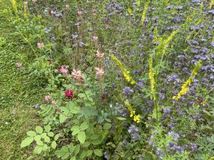 |
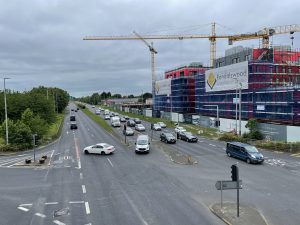
| You get off the bus at Palmerstown. Apparently it used to be a peaceful suburb to the west of Dublin until suddenly the R148 happened. I’m all for progress, but this does look a bit insensitive. An underpass would have achieved the same effect with far less impact. But, as always, I guess cost was probably the determinant | Pretty wildflower bed in Waterstown park. I think the yellow, pink and red flowers are all related members of the Medick (Medicago) genus, which also contains crops like alfalfa (lucerne) |
 |
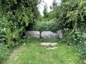 |
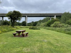
| Heading through Waterstown Park to the start of the riverside path, which goes upstream from here, under the motorway flyover | This is the western end of Waterstown Park. You have to squeeze through a gap in the boulders to get to the rough path beyond, which leads under the M50 bridge and then upstream to the weir. It’s all perfectly negotiable, if a bit tough going, but you get the distinct impression that you aren’t really supposed to be there. By there aren’t any “No trespassing” warnings, which I took to be a good sign. |
 |
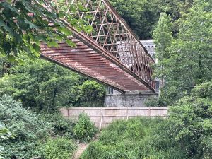 |
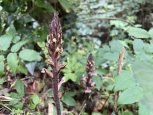
| Broomrape (Orobanch minor) growing alongside the path to the weir. It’s a strange plant which has no chlorophyll to make its own food, so it parasitises the roots of surrounding plants. I’ve seen it growing in crop fields, but never in heavily overgrown woodland like this. It’s not thought to be a native Irish plant but exactly how it got here isn’t clear | The Farmleigh bridge, AKA the Silver Bridge, is just beyond the eastern end of Waterstown Park. You have to fight your way along a rough path overgrown with brambles and nettles to get to it. |
 |
|
| See! I made it to the Wren’s Nest weir. But no kingfishers (or wrens, for that matter) to be seen. To be honest, it’s a bit of a creepy spot, so I didn’t linger. By the way it’s named after the nearby Wren’s Nest pub, and is popular with canoeists | |
Interactive map
(Elevations corrected at GPS Visualizer: Assign DEM elevation data to coordinates )
Max elevation: 49 m
Min elevation: 9 m
Total climbing: 214 m
Total descent: -220 m
Total time: 02:31:14
You can read earlier and later days’ blogs below
Previous day’s blog
Next day’s blog
Ireland home page
 Save as PDF