Ireland day 0226. Thursday 12 May 2022- Leprechauns
| Today’s summary | Drove up to Ballymakellett to check out route for Saturday’s DWC walk. A bit worried that it might clash with the Annual Leprechaun Hunt – but all seemed OK. A good day out | ||||
| Today’s weather | Overcast all day with a few heavy showers. Moderate south westerly wind. About 12C | ||||
 |
 |
||||
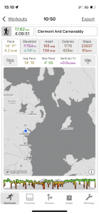
| Today’s overview location (The blue mark shows the location of my route) |
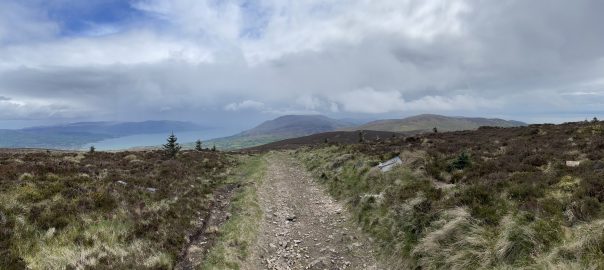
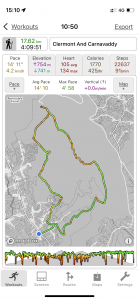
Close-up location (The green line shows where I walked) (Click button below to download GPX of today’s walk as recorded, or see interactive map at bottom with elevations corrected): Carnavaddy loop with Clermont detour |
||||
Commentary
For anyone not familiar with them, leprechauns are mischievous diminutive fairies, usually male and solitary, who dress in green and live in the hills and mountains of Ireland. They are said to be responsible for the crocks of gold that you find at the end of rainbows.
The reason I mention this is because I have been worrying about leprechauns for the last few days. Ever since, in fact, I read in my guidebook that the annual leprechaun hunt was usually held on a weekend in mid-May, and that the hunt itself was centred on the village of Carlingford. This is obviously an important occasion – on a par with the haggis hunts that are held from time to time in Scotland – and it was a worry to me because I’m leading a walk in the Cooley mountains, which are only a stone’s throw from Carlingford, this Saturday. I.e. right in the middle of the leprechaun hunting season.
So I decided that I better head back up to the Cooleys today, to recce the route of Saturday’s walk, and to see if there were any advance warning signs about the impending hunt. The drive up to Ballymakellett from Malahide couldn’t be easier. Basically it’s just 1 hour up the M1 and you are there. The normal start point for walks is the Lumpers pub – which has a large car park that they let you use (albeit for a €5 fee) and a coffee van to provide pre-walk refreshment. But weirdly for an Irish pub, when I got there, it was closed, and it remained that way all day (fortunately there was off-road parking on a side street nearby).
Perhaps they are suffering from Covid like us, or maybe the hunt has been postponed. But as I headed up into the mountains, much to my relief, the absence of leprechauns, and of any sign of hunting paraphernalia, was palpable. So I think we should be OK on Saturday unless the pub is closed again (which would be a minor calamity as I was counting on it for post-walk refreshment).
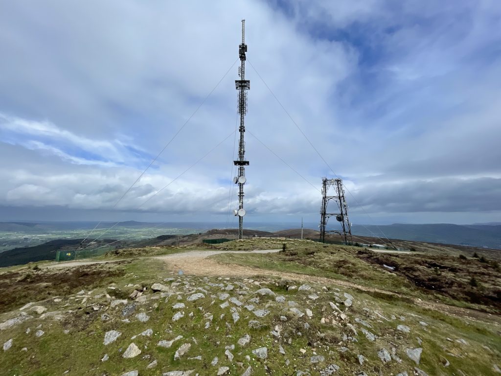
Concerns about supernatural beings dispelled, I continued up into the hills, following the now-becoming-familiar track up to the poc fada course, and the faux dolmen at Anaverna. Once up on mountain ridge above the drumlins, I normally turn right and head south towards Carnavaddy. But this time I thought I would vary things a bit by turning left to make the short detour to the summit of Black Mountain. There’s a massive radio mast up there, but of more prosaic interest is Clermont Cairn – a megalithic chambered cairn – which decorates the summit. It was a bit cold and windy today so I didn’t hang around to check it out properly. Perhaps if we have time, and the weather is decent, we will give it a more thorough inspection on Saturday.
I always enjoy the walk back along the summit ridge towards Carnavaddy – it feels lofty and airy, and today had the added bonus of, for the first time, not being in cloud. So I could see in all directions – Carlingford Lough on the left, and Dundalk on the right. And I could also see the stormy downpours heading across the Irish hinterland directly towards me, well before they arrived. At least it gave me plenty of time to get my jacket and over-trousers on.
From the top of Carnavaddy almost as far as where you pick up the Tain Way long distance track, it is more or less pathless bog. But with a bit of careful navigation, you can pick a way through without too much difficulty, and it certainly helped that today I could actually see where I was going. Once off the bog, it’s an easy walk along good paths to the top of the forestry plantation, then down through the trees back to Ballymakellett. I kept a good look out but didn’t see any diminutive little green men on my way down either, so my journey back to the car was straightforward and unimpeded (apart from a quick break to enjoy my packed lunch).
Now I’m safely back in the flat – for once not soaked through – and unlike the last time I did this walk, I don’t feel like I’m coming down with Covid. Famous last words. I’m keeping my fingers crossed that neither virus nor fairy strikes between now and Saturday, so wish me luck!
Today’s photos (click to enlarge)
 |
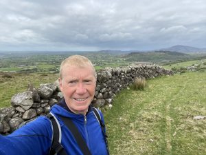 |
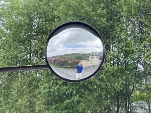
| The man in the mirror. On the very posh road that leads out of Ballymakellett up to the mountains | Off the road at last, and into the countryside. freedom! |
 |
 |
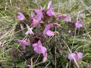
| I have always liked this plant, with its attractive pink flowers that decorate mountain bogs throughout the British Isles. It’s a bit of a pity though that it has such un unattractive name – common lousewort (Pedicularis sylvatica). Though it does have the rather unattractive habit of being semi-parasitic on nearby plants. It got its name from the ancient belief that cattle eating its leaves would get lice | Up by the faux dolmen at the start of the poc fada course (see the blog from 18 March for more background on this) |
 |
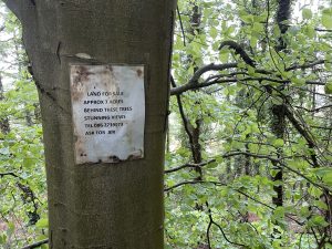 |
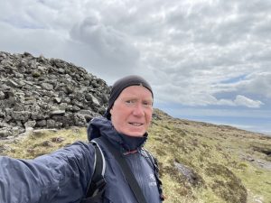
| Looking rugged at the top of Carnavaddy. It’s the third time I’ve been up here recently, and the first time that I’ve actually been able to see anything | The sign on the tree says : “Land for sale. Approx 7 acres behind these trees. Stunning views. Tel 086 2739073. Ask for Jer“. I would have been tempted if it wasn’t for the fact that the land behind these trees is nearly vertical, and of no practical use for anything at all |
 |
|
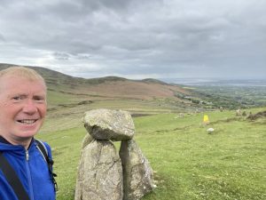
| The mast-adorned summit of Black Mountain, from Clermont Cairn. The cairn is marked on the map as being a megalithic tomb, making it about 6000 years old. It’s actually said to be the remains of a chambered cairn, and three lintel stones are visible on the southern side, if you know where to look. Unfortunately I didn’t see them. There is a cairn of similar appearance on the top of Carnavaddy but I don’t know if it is of similar vintage | |
Interactive map
(Elevations corrected at GPS Visualizer: Assign DEM elevation data to coordinates )
Max elevation: 506 m
Min elevation: 57 m
Total climbing: 724 m
Total descent: -724 m
Total time: 04:09:48
You can read earlier and later days’ blogs below
Previous day’s blog
Next day’s blog
Ireland home page
 Save as PDF