Ireland day 0208. Sunday 24 April 2022- Carriglinneen
| Today’s summary | Drove down to Glenmalure via Laragh to join Dublin Walking Club for a circuit round Carriglinneen Mountain (didn’t have time to go to the summit). Only three of us today and Val was at work too! Nevertheless a very enjoyable and sociable day out | ||||
| Today’s weather | Bright and dry again. Cool in the morning at the start. Sunny and warmer in the afternoon. Moderate northerly wind. About 13C | ||||
 |
 |
||||
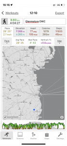
| Today’s overview location (The blue mark shows the location of our route) |
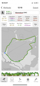
Close-up location (The green line shows where we walked) (Click button below to download GPX of today’s walk as recorded, or see interactive map at bottom with elevations corrected): Glenmalure Carriglinneen DWC |
||||
Commentary
For the past few weeks now, we seem to have been stuck in a weather pattern here in Ireland, which is sweeping cool dry air over the whole country from a north easterly direction – straight from arctic Scandinavia. It means that the days are dry, sunny and bright, but there’s always a nagging cold breeze which means that shorts are only for the brave (like me) and if you pause for lunch while out on a walk, you definitely need to find a sheltered spot. It also means that the ground is very dry – which is great for walking but which I fear will lead to water shortages later in the summer if it doesn’t start raining soon.
Anyway this is just a long way of saying it was another sunny dry day today so the great outdoors beckoned once again. Unfortunately Val was working but as I had discharged my domestic obligations by cleaning the flat and doing the shopping yesterday, we agreed that while she was out working, I would go out and join the Dublin Walking Club for another exploration of the Glenmalure area. I’d arranged to pick up some fellow walkers at Laragh, so we popped into the pub for coffee and scones (yes – before we even set off!) and then car shared for the last leg of the journey over the hill to Glenmalure Lodge.
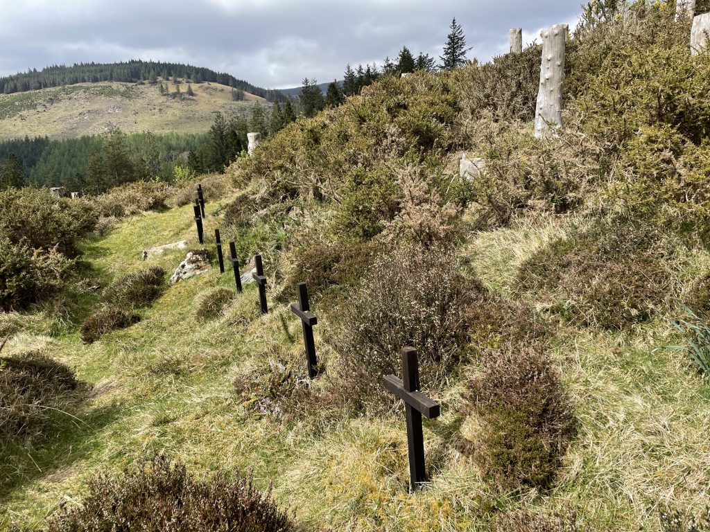
For reasons that weren’t entirely clear to any of us, there were only three of us on the walk today. It’s a shame for those who didn’t go, as it was an enjoyable and interesting outing in near-ideal conditions. We headed up a forestry track from Glenmalure, aiming for the Shay Elliott car park at Three Crosses Pass where the old military road comes over from Laragh. En route, we managed to find the Twelve Graves of Ballybraid – and you can read the gruesome back-story to this hallowed spot in the photo caption below.
From the pass we had originally intended to go up to the top of Carriglinneen but we found a sunny spot and stopped for lunch. By the time we’d finished – and completed the next instalment of the inevitable chat – we were a bit short of time so cut down to the morbidly-named Funeral Road for the short stretch back to Glenmalure rather than making the full ascent. After all, it will still be there for another day.
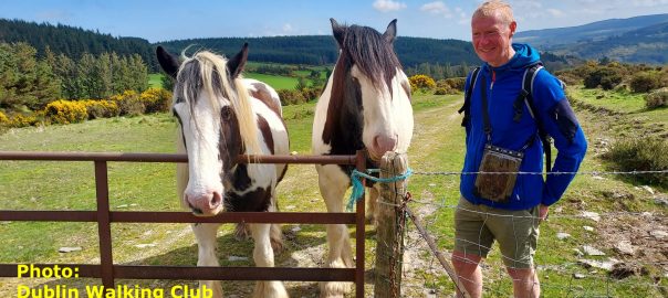
En route, we came across a couple of huge and somewhat intimidating carthorses that between then seemed entirely to fill the field we needed to cross. Fortunately they were inquisitive rather than aggressive so after giving our rucksacks a good sniff they evidently determined that we were food-less and soon lost interest and wandered off. The rest of our descent was unimpeded and we were free to enjoy the absolutely stunning banks of gorse, sunflower yellow against the Ukrainian blue sky.
We were back at the Glenmalure Lodge by about 4 and although a Guinness would have been lovely, driver’s responsibilities precluded it so I had to made do with a Diet Coke while the others managed something a bit stronger. Once refreshed, it was a quick spin back to Dublin (no fuel crises this time, I’m pleased to report) then time to sample the ginger, onion, soy sauce and wholewheat noodles that I had part prepared yesterday (and which Val skilfully completed).
We treated ourselves to a G&T in lieu of the missing Guinness then finished off the evening with a sociable Zoom chat with friends who’ve recently moved to Scotland. It’s reassuring to find, by speaking to friends like this, that everyone who makes these big locational upheavals seems to face similar challenges with bureaucracy and social integration. It’s definitely given me a much better appreciation of just how hard it must be for people coming to the British Isles from much farther afield, and even more so when English isn’t their native language. I’ll certainly never again take simple things like driving licences for granted quite as readily, now I know just how hard you have to work to earn them.
Today’s photos (click to enlarge)
 |
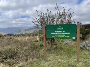 |
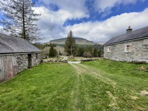
| Farmstead marking the entrance to Ballybraid, where it joins the Ballyboy Brook. It’s not inhabited now but still in good shape and apparently still occasionally used, possibly as a rental cottage | The Shay Elliott car park, where the forestry path from Glenmalure meets the road from Laragh. Shay Elliott was a renowned Irish cyclist who frequented the roads through these hills and who came from nearby Kilmacanoge |
 |
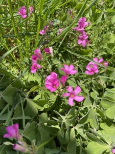 |
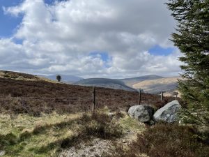
| Beautiful lunch spot on the slopes of Carriglinneen, looking south over Glenmalure towards Lugnaquilla | I’d be tempted to say this was a fine example of Shamrock but unfortunately it isn’t. It’s actually Pink Sorrel, Oxalis articulata. It’s not even native to Ireland – it is a garden escape and originally came here from South America. By the way as far as I can tell, shamrock is just common or garden clover |
 |
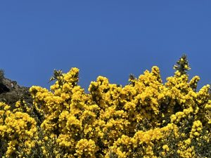 |
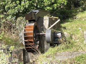
| Unusual water mill (now no longer functioning) just outside the Glenmalure Lodge at the start / finish of the walk | Gorse and blue sky a fitting yellow and blue reflection for today’s troubled times |
 |
|
| The Twelve Graves of Ballybraid. High up on the hillside, you come across these twelve otherwise unmarked graves. They mark the site of a tragic event in 1590 when Oliver Cromwell’s troops, hell-bent on stamping out the burgeoning Catholic Confederacy in Ireland, came across a local group attending an illicit open air mass. Unfortunately their guard had fallen asleep so was unable to raise the alarm. Eleven of the congregation, plus the lookout guard, were massacred by the troops. The graves mark the spot (or thereabouts) where they were slain. | |
Interactive map
(Elevations corrected at GPS Visualizer: Assign DEM elevation data to coordinates )
Max elevation: 383 m
Min elevation: 128 m
Total climbing: 410 m
Total descent: -408 m
Total time: 04:04:18
You can read earlier and later days’ blogs below
Previous day’s blog
Next day’s blog
Ireland home page
 Save as PDF