Ireland day 0135. Thursday 10 February 2022- Preparation
| Today’s summary | Took the DART down to Bray to do another recce for Sunday’s walk. Val checked out the cliff path section, I did Bray Head | ||||
| Today’s weather | Sunny and bright all day. Feeling cold in moderate north-westerly wind. Light rain shower on way back in the afternoon. About 7C | ||||
 |
 |
||||
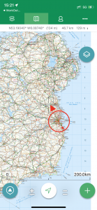
| Today’s overview location (the red cross in a circle shows where Val and I are at the moment) |
Close-up location (Click button below to download GPX of today’s walk as recorded, or see interactive map at bottom with elevations corrected): Bray second recce |
||||
Commentary
This coming Sunday is a big day as far as I am concerned. I’m leading a walk for the Dublin Walking Club and as it’s the first time I’ve led a walk outside the UK, I want to make sure it goes as well as it can. In the interests of full disclosure, I should also explain that the walk is being co-led by Val as well as me – which is a good thing as I’m thinking that we may have to split the group into two if a mixed-ability crowd of walkers turns up on the day.
In case you’d forgotten, Sunday’s walk will explore Bray Head, which is about 15km south of Dublin, in Co. Wicklow. We all know that prior planning and proper preparation prevents p*ss poor performance. So even though we had already recce’d the route once before (there was a blog about it last month which also gives all the historical background to Bray and the environs, if you’re at all interested), I thought it would be good to go back and do it again, in case anything had changed in the intervening few weeks.
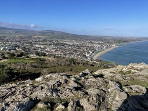
The first thing you will notice when you look at the photos below is that there is a lot of blue in them. I don’t want to tempt fate, but this is the second time we have had excellent sunny weather like this on Bray Head and I know it can’t possibly last until next Sunday. Anyway we enjoyed it for what it was today – simply stunning. Fabulous views all around, and lots of bright sunshine. But it did feel cold – the temperature was only 3C when we set off and struggled to reach 7 by mid afternoon – and felt a lot cooler in the wind.
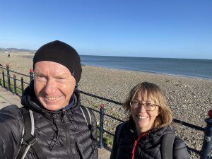
We didn’t hang around in Bray once the DART deposited us at Daly station. (By the way Bray station is named after Ned Daly, one of the leaders in 1916 who was executed after the Easter uprising. Dublin’s Pearce, Heuston and Connolly stations are so-named for similar reasons).
Once on the promenade, we headed south and when we reached the point where the steep path branches off the cliff path and winds its way up to Bray Head, we decided to explore the two alternative routes separately from here. Val volunteered to check out the level route south along the coast path, while I branched off up the steep path towards the Bray Head summit itself. Hopefully, by offering two routes, we should cover all bases on Sunday. Fingers crossed.
There’s not too much to say about Val’s and my walks south via the two routes. All the details of the views and terrain are in last month’s Bray blog but suffice it to say that today they were both excellent and both straightforward. The one thing that was missing was people crowding the path – this was a welcome absence and a consequence of the midweek timing. I fear that it will be much busier on Sunday, if the weather is at all decent.
We rendezvoused about an hour and a half later, where the summit path drops down to meet the cliff path. The meeting place is just before the point where the path to Greystones is officially closed because of the landslide, so it’s an ideal spot to head for before walking back along the cliff path to Bray and the finish of the walk. By chance, from looking at an old map, Val spotted that on a grassy hillside just below this point, there is a white stone “EIRE” sign. If you want to know more about the historical significance of these signs, and their relationship to Ireland’s role in the second world war, you’ll need to check back on the Howth blog last October. Although some relics of the sign are still there, even though we had a good ferret around, I don’t think you would really notice anything much unless you knew exactly what you were looking for.
From there, we took a brisk walk back to Bray along the coast path. The path, being in the east side of the hill, falls into shade in the early afternoon so the combination of being out of the sun, and heading into a strong northwesterly wind, made it feel quite chilly. So we didn’t linger. Once back in Bray, there was time for a delayed picnic lunch in the shelter of some rocks on the beach, then up to the station for the DART train back to Malahide.
As a footnote, one of the side effects of the Covid pandemic is that in the interests of ventilation, all the windows on the DART trains have to be left open. That makes them very cold and it’s almost impossible to find a spot that isn’t draughty (Val tells me that it is very old-peoply to go on about draughts, by the way). So by the time I got back to the flat It was frozen solid and it’s taken me about three hours with the heating on max to start to warm up. But it’s wine o’clock now, and I am sure that will go a long way toward rectifying this troubling situation.
So now we just have to hope for the best on Sunday!
Today’s photos (click to enlarge)
 |
 |
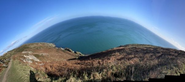
| Setting off from Bray this morning. It looks like the Cote d’Azur but in the cold wind it didn’t feel like it | Looking north from the summit of Bray Head (the one with the cross pictured at the bottom of this blog) over Killiney Bay towards Dalkey Head. It’s been likened to not to the Cote d’Azur but to the Bay of Naples, hence the Italianate place names near here (like Sorrento Terrace and Vico Road) |
 |
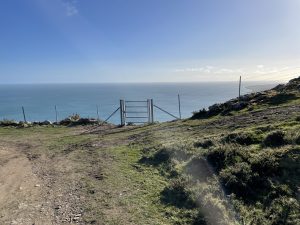 |
| On the top of Bray Head Hill (not the same as Bray Head, confusingly – it is about a kilometer south of Bray Head, about 40 metres higher, and has no cross. It’s also far less frequently visited | The “Carriage Path” links Bray Head to Bray Head Hill and you can branch east off it either to get to the top of the Hill, or to dive through this gate and plummet (not literally, but steeply nevertheless) down to the Cliff Path below |
 |
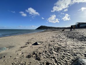 |
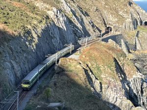
| Just caught this DART train snaking its way along the coastal railway heading south from Bray to Graystones. Note that it’s single track, which I guess must restrict traffic a bit but as it’s already the most expensive piece of line in Ireland to maintain, I don’t see much prospect of it ever being upgraded | Back on the beach in Bray at the end. There were even some swimmers out today, though I have to admit I was struggling to stay warm even with about fifteen layers of clothes on. |
 |
|
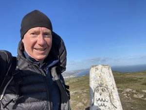
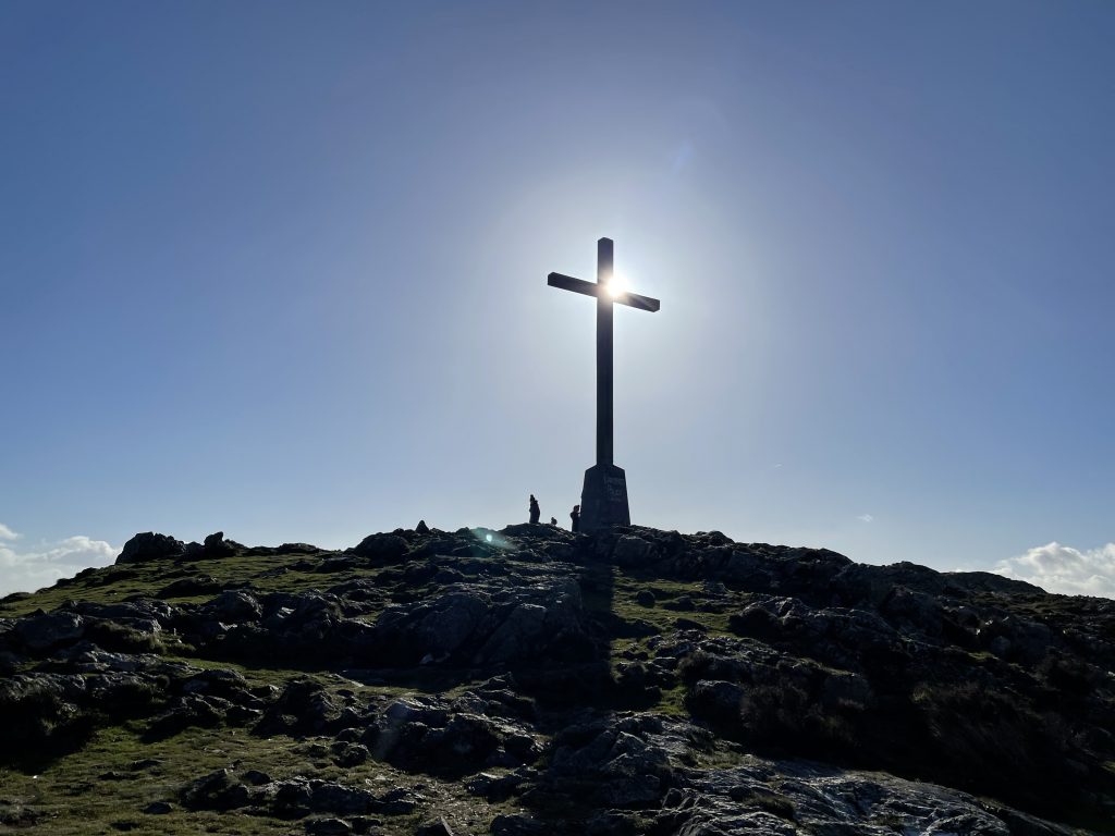
| Approaching the cross on the top of Bray Head. We’ve been lucky with the weather both times we have been here so I’m rather getting used to the idea that it’s always sunny up here. I just hope Sunday doesn’t disprove that happy assumption | |
Interactive map
(Elevations corrected at GPS Visualizer: Assign DEM elevation data to coordinates )
Max elevation: 231 m
Min elevation: 0 m
Total climbing: 709 m
Total descent: -720 m
Total time: 03:01:16
You can read earlier and later days’ blogs below
Previous day’s blog
Next day’s blog
Ireland home page
 Save as PDF