Ireland day 0128. Thursday 03 February 2022- Coast
| Today’s summary | Val returned to UK for a couple of days so after leaving her at the airport, I took the 102 to Sutton to meet a walking club friend then walked up the coast to Donabate and caught train back to Malahide. High tide made negotiating the Broadmeadow lagoon a bit tricky | ||||
| Today’s weather | Mild and bright in the morning. overcast with moderate westerly wind in afternoon. About 12C | ||||
 |
 |
||||
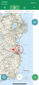
| Today’s overview location (the red cross in a circle shows where Val and I are at the moment) |
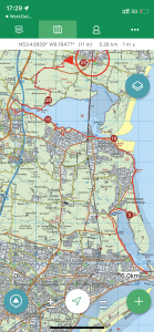
Close-up location (Click button below to download GPX of today’s walk as recorded, or see interactive map at bottom with elevations corrected): Sutton Donabate coast |
||||
Commentary
Val has gone back to the UK for what she calls a “girly weekend”. To me this sounded like an entirely frightening concept, best avoided, and I wisely decided to stay put in Ireland.
So it was another early start this morning, to catch the now all-too-familiar 102 bus to the airport. I think I know this route better than most of the drivers now. We successfully made it to the airport with plenty of time to spare – probably because we got the bus earlier than we actually needed to because the last two 102’s I have aimed to catch have both been cancelled. So we said our goodbyes (she’s back on Monday) and I got a coffee then headed back to the bus station.
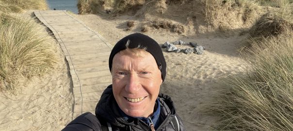
I caught the 102 again, but this time instead of getting off at Malahide, I continued to the end of the line at Sutton – just inland from the Howth peninsula. I had to pick up some gear from a friend in the walking club and who lives in Sutton, so today was a perfect day to make the rendezvous. Once the clobber was successfully exchanged, I decided to take advantage of the good weather and to walk back up the coast to Malahide rather than getting the 102 bus (or the DART) back. I like the coast walks round here, and as the weather was nice, it looked like the perfect excuse for a leg-stretch.
The route to Malahide was familiar – Val and I have walked it a couple of times now – but it’s always fascinating. You see different things depending on the weather, time of year and, around these parts, the tide. And today as I skirted the coast, it was a very high tide indeed. On the grassy stretch from Portmarnock Bridge towards the golf club road, the ground, which my map tells me is at most one metre above sea level, was distinctly squelchy as the seawater soaked into it. Quite how the grass survives the saline conditions I don’t really know.
When I arrived at the point where the Velvet Strand normally is – it just wasn’t there. The high tide had almost completely submerged it, squeezing walkers, dogs and swimmers into a narrow strip of dry sand less than a metre wide in some parts. Nevertheless it was an enjoyable walk and the views, as ever, were uplifting. I made good progress despite the tide, and was back in Malahide – my intended destination – before 2pm which was much earlier than I expected. So I modified my plan, and thought I’d try continuing along the coast, right up as far as Donabate. Then catch the train back for the short journey across the lagoon.
This was one of those plans that seemed like a good idea at the time but which lacked proper thinking through. I’d forgotten that the north side of the Broadmeadow lagoon is prone to flooding and with it being an exceptionally high tide as I was making my circumnavigation, this indeed proved to be the case. I know that parts of the northern coastal road are almost always under water (I have already gone on about this at great length so won’t repeat my grumbles here) but I’d never had problems accessing the main stretch that I wanted to use today. So I just assumed I’d be able to get round without problems.
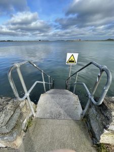
That was a mistake. The normally-dry road got closer and closer to the waters edge and then finally disappeared beneath the waves completely. For part of the way I was able to clamber above the water on a narrow ledge built into the seawall, but eventually even that gave out and to continue would have necessitated a paddle along the flooded road which looked to be at least half a metre under water.
Fortunately at that point I was able to get away from the coast along a narrow road leading north which was fine, though it headed north west rather than north east, so was taking me away from my destination at Donabate. Then it deposited me on the busy R126 (ominously known as the “Hearse Road”) which I’d already noted had no footpaths alongside it. So I dodged the rushing oncoming traffic for an unpleasant kilometre then arrived at the southeast corner of the Newbridge estate. I wasn’t certain whether the demesne would still be open as it was going up to 5pm by the time I got there, but fortunately it was (it didn’t actually close tonight until 6pm). So I was able to escape into the blissful peace and quiet of the grounds and follow one of the many grassy paths across the parkland to the eastern exit.
From there it was just a short hop to the railway station and fortunately I didn’t have too long to wait for a train back to Malahide.
So today didn’t quite work out as I had planned, but very enjoyable nevertheless. And very satisfyingly, it started raining soon after I got back to the flat, leaving me feeling warm, dry and smug inside.
Today’s photos (click to enlarge)
 |
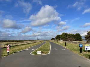 |
| The weather was lovely when I set off from Sutton just before 12. The tide was almost fully in – I think it peaked about 1pm and seemed to be quite a bit higher than normal. There was a lot of flooding of fields, paths and even a road near the shoreline. The Velvet Strand at Portmarnock had almost completely disappeared | The beautiful Baldoyle Greenway – from nowhere to nowhere. |
 |
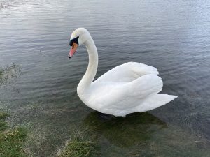 |
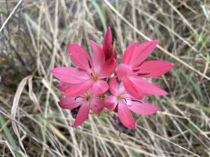
| River lily, Hesperantha coccinea in full bloom on the roadside just outside Portmarnock. They are a beautiful species originating from Southern Africa and normally flower in the autumn. Never seen one in bloom in February before | Spectacular swan, looking just like it’s come straight from a packet of matches. There are literally hundreds of them in the Broadmeadow lagoon. During the time we have been here, last year’s cygnets have gradually shed their juvenile brown plumage and are slowly becoming swan-coloured. It won’t be long now I guess until the next generation of ugly ducklings arrives |
 |
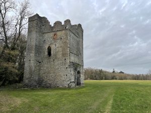 |
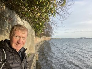
| The tide was still pretty high by the time I got to the northern side of the Broadmeadow lagoon. Even the bit of the road which is normally above water was submerged, necessitating a precarious teeter along a ledge with the water quite literally lapping at my toes | Eventually, after a bit of a detour to avoid a completely flooded section of the coast, I made it to the Newbridge demesne. This ancient ruin – Lanestown castle- was built in the 15th century though not a lot seems to be known about it other than it was apparently “in use” until the late 1700s. It was a cattle shelter until the 1970s. Ireland is literally dotted with fascinating ancient monuments like this, but they seem sadly uncared for and you can’t help wondering how much longer it will be before they crumble away completely |
 |
|
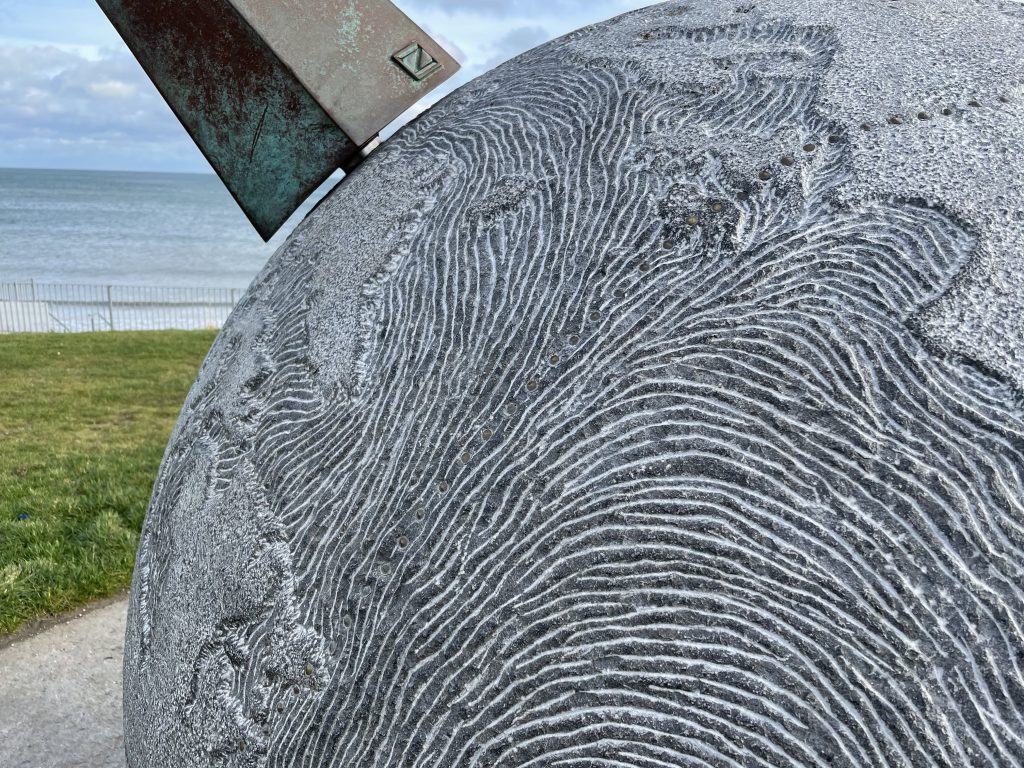
| Now here’s a thing. This sculpture at the northern end of the Velvet Strand at Portmarnock is known as “Eccentric orbit”. It is a complete sphere and studded round a circumference are a series of bronze dots (you can just make them out on the picture above). These record the flight path of the “Southern Cross”, which was one of the first aircraft ever to circumnavigate the globe. On 24 June 1930, the aircraft, a three-engined Fokker piloted by Australian Charles Kingsford-Smith, took off on the transatlantic leg of the circumnavigation. (It was actually supposed to leave from the west coast of Ireland but had to change plans and come to Portmarnock at the last minute because of bad weather). They successfully made land fall in north America, at Harbour Grace in Newfoundland, after some 31½ hours in the air. The photo above shows the section of the route as it crosses the Atlantic from Portmarnock to Newfoundland. Sydney’s international airport is named after Kingsford Smith. | |
Interactive map
(Elevations corrected at GPS Visualizer: Assign DEM elevation data to coordinates )
Max elevation: 17 m
Min elevation: -4 m
Total climbing: 355 m
Total descent: -349 m
Total time: 05:30:33
You can read earlier and later days’ blogs below
Previous day’s blog
Next day’s blog
Ireland home page
 Save as PDF