Ireland day 0275. Thursday 30 June 2022- Tonelagee
| Today’s summary | Took advantage of a free day and a half-decent weather forecast to drive down to Laragh to walk a circuit including the summit of Tonelagee, from Laragh via Brockagh, returning down Glendasan on St Kevin’s Way via Glendalough. Very good. | ||||
| Today’s weather | Very wet overnight but stayed dry all day. Some sun. Light westerly wind. About 18C | ||||
 |
 |
||||
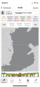
| Today’s overview location (The blue mark shows the location of my route) |
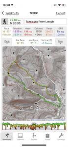
Close-up location (The green line shows where I walked) (Click button below to download GPX of today’s walk as recorded, or see interactive map at bottom with elevations corrected): Tonelagee from Laragh |
||||
Commentary
A few weeks ago, I was kindly given a book by one of my fellow Walking Club members. The book was “Hill Walkers Wicklow” by David Herman. I’d thumbed through it several times and one walk which it described kept jumping out at me – an ascent of the mountain Tonelagee, which lies to the east of the Wicklow Gap, at the top of the Glendasan valley.
I’m not quite sure why I was attracted to it – perhaps it was because I’d spied the mountain from afar (most recently when we did the St Kevin’s Way walk over the Wicklow Gap) but perhaps also it was the name – Tóin le Gaoith in Irish means “arse to the wind” which evidently caught my imagination. If nothing else the name gives you an idea what the weather is like up there. Oh and the other thing is Lough Ouler – aka the heart-shaped lake. It’s nestled on the north east flanks of the mountain and widely features in Irish tourism literature. I wanted to have a look at it.
So I thought today would be a good day to drive down to Laragh and try out a circular hike taking in an ascent of Tonelagee. I didn’t follow the route in the book exactly – I ascended via the route David Herman uses to come down, and then returned via the Wicklow Gap and St Kevin’s Way, with which I was already familiar. The weather forecast was looking a bit iffy – but it’s at best “mixed” for the next few days, so today was as good as any. I packed a selection of cold weather, windy weather and wet weather clothes and set off down the M50.
There’s a large car park hidden away in some woodland at Laragh, and I decided to park there rather than by Lynam’s hotel, as I wasn’t planning to go to the pub at the end of the walk. I did feel slightly uncomfortable leaving the car there as the trusty Yaris was the only vehicle in the car park, and it was a bit secluded. Anyway I decided to chance it and set off anyway.
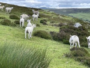
The first part of the route I’d plotted took me up Brockagh – a subsidiary summit to the south east of Tonelagee. The walking was excellent – the path was well made up and despite the recent heavy rain, it was easy going. The rain had also turned everything vivid green again – it’s like the spring has returned and the Emerald Isle has been resurrected. I was quickly up on the bouldery top with just a few sheep for company. After a quick pause to admire the view, I set off on the more challenging 5km / 3mi slog along the broad grassy ridge that leads from Brockagh to the flanks of Tonelagee-proper.
I’d heard that the ridge could be boggy , and after the recent rain I feared the worst. Actually, although was it was indeed pretty squelchy, it wasn’t as bad as I had expected, and I made reasonable progress, hopping from peat hag to peat hag. After about an hour I was at the base of the main climb up Tonelagee – the angle picks up quite abruptly, and the path profile looks rather like a hockey- stick. But I soon got into a decent rhythm and plodded slowly upwards. With the slope being much steeper here, it was better drained so was a lot less muddy, which definitely helped.
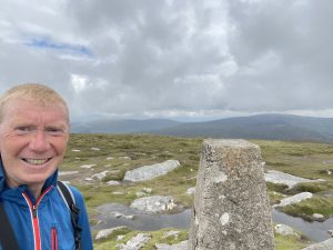
Soon the trig point came into view. It’s worth noting, in case anyone is interested, that these trig points can be found on summits all across Ireland. They were installed by the Ordnance Survey Ireland in about 1959 as part of the trigonometric survey of Ireland, and were built to the same “Brigadier Martin Hotine” design as their counterparts in the UK. Also like the UK equivalents, they are redundant now, as GPS and aerial techniques have superseded land-based measurements. But they are as much-loved by hikers here in Ireland as they are in the UK and as far as I can tell there is no move to get rid of them. For me, at least, it’s always very reassuring to get to the trig point and realise that you probably are in the right place after all.
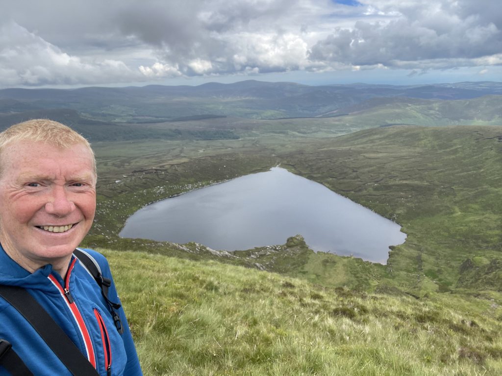
I paused briefly at the top but I could see what I thought were rain clouds gathering out to the west so, before the fog came down, I took a short detour north west from the summit to peer over the edge and down onto Lough Ouler. From this angle, it was “upside down” so it wasn’t quite as impressively heart shaped as it could have been, but nevertheless it looked lovely and I was pleased to have seen it. But the most striking thing about the view from this spot was the complete and utter absence of any other human being in the panorama from near to far horizon, from east to west. As I hadn’t seen anyone on the way up, nor anyone on the top, I realised that I had the whole of this huge mountain completely to myself. A rare, and quite surreal, moment.
From my lofty eyrie overlooking Ouler I retraced my steps back up to the top of Tonelagee, then straight over the other side to take the quick path back down to the road at Wicklow gap. The rain was still threatening so I didn’t stop for lunch until I was well down St Kevin’s Way and heading for Glendalough. By then the threat of a downpour seemed to have receded – in fact it stayed dry all day despite my misgivings – and anyway there were a number of old mine buildings near my lunch-spot where I could take refuge if the heavens opened.
After lunch, and with a definite spring in my step, I retreated down the valley, following in Kevin’s footsteps, and was down at Glendalough in what felt like next-to-no-time. I crossed over through St Kevin’s monastery to join the main path out of Glendalough, and cruised smoothly back down the broad track into Laragh.
Once back at the car park, I discovered that all was well, and in fact the parking was almost completely full by the time I returned. Lots of groups of hikers must have arrived soon after me, so I think I was worrying about the Yaris unnecessarily. I paused at the car to finish off my lunch – I had kept some in reserve in case of emergencies – rather like Paddington’s marmalade sandwich hat – then bade farewell to Laragh and a truly excellent day’s hiking.
One final note – Tonelagee is Wicklow’s third highest summit. Lugnaquilla – which I have climbed twice recently – is the highest, and Mullaghcleevaun is second. So I imagine you can guess what’s next in my sights – and it’s on page 61.
Today’s photos (click to enlarge)
 |
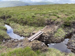 |
| On the way up Brockagh. Shawn the sheep! | There’s a sort-of path on the 5km / 3mi ridge between Brockagh and Tonelagee, but because the ridge is very broad and grassy, it doesn’t drain well. So after yesterday evening’s deluge, it was rather soggy going. This was the only bit of board-walking that I found |
 |
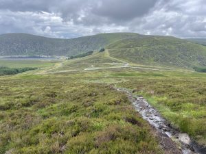 |
| At the trig point on the summit of Tonelagee. Took about 2¾ hours to cover the 11km to get here from the Laragh car park | Looking from the descent out over the Wicklow Gap to the Turlough Hill hydroelectric power station. It you expand the picture and zoom in a bit, you should be able to make out the upper and lower reservoirs of the pumped storage system |
 |
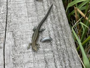 |
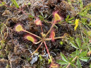
| A rather fine sundew (Drosera rotundifolia) eking out an existence in the bogs on the way off Tonelagee to the Wicklow Gap. It supplements the meagre nutritional qualities of the bog with insects which it catches on its sticky pads. A nasty carnivorous foe, especially if you are a small fly. | I’ve quite often seen these small lizards up in the mountains in both the UK and ireland (I saw five today). They seem to thrive in the cold soggy conditions up there, and I’ve come across them even on cooler days than today. It seems quite counter-intuitive as lizards are cold-blooded and I thought they generally preferred sunny dry and warm conditions. On doing a bit of research, it seems likely that they are actually vivparous lizards (Zootoca vivipara), which are renowned for their ability to thrive in subarctic climates. In fact in winter they can survive being frozen completely solid. Quite a remarkable creature |
 |
|
| I took a short side-trip from the summit to look down over the north eastern flanks of the mountain, down onto Lough Ouler. It’s not quite so obvious from this viewpoint, but seen from the other side the reason for its more common name – “The Heart-Shaped Lake” – is more obvious. From here I also had an excellent view right into the far distance. There was absolutely nobody in sight. I had the whole mountain completely to myself. That hasn’t happened to me for a very long time and it felt quite exhilarating | |
Interactive map
(Elevations corrected at GPS Visualizer: Assign DEM elevation data to coordinates )
Max elevation: 812 m
Min elevation: 126 m
Total climbing: 1007 m
Total descent: -1008 m
Total time: 05:36:33
You can read earlier and later days’ blogs below
Previous day’s blog
Next day’s blog
Ireland home page
 Save as PDF