Ireland day 1354. Friday 13 June 2025- Glendasan Recce
| Today’s summary | Left the flat early to drive down to Bride’s Glen. Picked up a Walking Club friend and we drove down to Glendasan to recce a long circular walk she is leading for the Club in a couple of weeks’ time. It all went straightforwardly and took in the summits of the Brockagh ridge, Tonelagee, Turlough Hill and Camaderry. Back at the car at about 5:15 then reversed the journey to Malahide. Val elected not to come, and had a relaxing day in the flat. Chicken stir-fry, red wine and “Mad Men” in the evening | ||||
| Today’s weather | Bright and breezy with plenty of sun and only the lightest of showers. Moderate south westerly wind. Appx 17c | ||||
 |
 |
||||
| Today’s overview location (The blue mark shows the location of our route) |
Close-up location (The blue line shows where we walked) (Click button below to download GPX of today’s walk as recorded, or see interactive map at bottom with elevations corrected): Brockagh Tonelagee Turlough Camaderry recce Marie |
||||
Commentary
I have to admit – I wasn’t particularly looking forward to today. I had agreed to join a Walking Club friend to recce a long-ish walk that she is leading in a couple of weeks’ time and I was a bit apprehensive about the likely underfoot conditions after the torrential soaking most of Ireland endured yesterday. Also, it’s a long walk and I knew it would be pretty tiring. In the end though, I needn’t have worried – it turned out far better than I had feared and I really enjoyed it.
Val elected to have a quiet day in the flat today so I set off on my own at 8am to drive round to Bride’s Glen to pick up my co-walker. Unlike yesterday, the traffic on the M50 was flowing well so I got there in plenty of time. Once I had picked her up, we drove on down to Glendasan and parked at the derelict Hero leadmine site, and headed straight up the valley slope to the crest of the Brockagh ridge. There is no path up the hill, so it’s slow going as the heather is deep so you can’t really see where you are putting your feet.
Eventually we gained the ridge and set off to plod along it in a westerly direction towards Tonelagee. The path is thin, to say the least, and the small wooden bridge which used to span one of the particularly deep peat groughs had been wrecked. So it was slow going, but much less wet than I expected. Eventually we made it to the top, about 2½ hours after setting off from the car.
We didn’t stop on Tonelagee summit as it was very windy and we knew we would struggle to find anywhere sheltered. So we carried straight on down to the Wicklow Gap and only there did we finally stop to have our lunch.
From our lunch stop it was a straightforward 45 minute climb up the hydro road to the upper dam on the top of Turlough Hill. All the way, the views were fantastic, just as they had been on Brockagh. It was a bit too hazy, though, to make out the Welsh coastline today. On Turlough, we exchanged friendly greetings with some ESB engineers who were working up there and then plunged off onto the broad marshy whaleback linking Turlough to Camaderry.
We eventually made it to the final summit cairn, though navigating the cluster of peat-hags midway along is always a challenge. So just like on the Brockagh ridge, progress was slow. But once we had ascended our final summit, we descended quite quickly and were back at the Hero mine car park, and the car, by about 5:15pm. The walk was just over 16km and it took us about 6½ hours. Today was the fifth time we have walked this route, and this was actually our quickest time of all five.
Once back, I repeated the outward journey, dropping my friend at Bride’s Glen Luas and then making my way to Malahide round the still remarkably quiet M50. Back at the ranch, Val had made a delicious Chicken stir fry with noodles, which we jointly enjoyed with a glass of red wine. Then once I’d done the washing up (the least I could do to contribute), we rounded off the evening with another episode of “Mad Men”. We are in the final season now, but still about 13 episodes to go.
Altogether an unexpectedly enjoyable day out – much better than I had expected. Long may these pleasant surprises last!
Today’s photos (click to enlarge)
 |
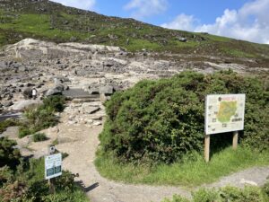 |
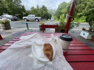
| Essential start to the day at the lovely Glendalough café in Laragh | Ruins of the Hero mine at the start (and end) of the walk |
 |
 |
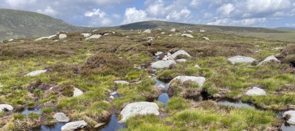
| A thin path leads along the Brockaghs “ridge” to Tonelagee (the hill on the skyline in the background). It’s only just over 3km all the way along, but it takes ages because it’s very wet and because you have to pick your way carefully through the bog and boulders | On the top of Tonelagee. Windy, as always. It took us about 2½ hours to get there from the car park, even though it’s under 6km |
 |
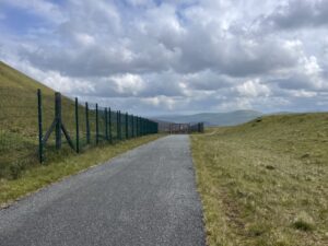 |
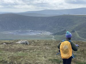
| Surveying Lough Nahanagan from the descending flanks of Tonelagee. The two Younger Dryas terminal moraines are just visible in the lough at the low water mark | Up on Turlough Hill. The reservoir is behind the embankment on the other side of the fence |
 |
|
| Almost back. The view down Glendasan from the Hero lead mine. St Kevin’s Way leads down from the mine all the way to Laragh | |
Interactive map
(Elevations corrected at GPS Visualizer: Assign DEM elevation data to coordinates )
Max elevation: 812 m
Min elevation: 276 m
Total climbing: 901 m
Total descent: -900 m
Total time: 06:34:24
You can read earlier and later days’ blogs below
Previous day’s blog
Next day’s blog
Ireland home page
 Save as PDF