Ireland day 1440. Sunday 07 September 2025- Glendasan DWC
| Today’s summary | Val was working in the museum and I got a lift with a couple of friends down to Laragh for a Club walk into Glendalough and over to Glendasan. Coffee and scones in Lynhams then started the walk in drizzly rain and mist. Skies cleared around lunchtime so we had sun for lunch on the spur between the two valleys. Beautiful views after the weather brightened, and excellent views. Great company and a quick drive back. In the flat about 5pm just before Val. Beef casserole again for dinner | ||||
| Today’s weather | Overcast and wet first thing. Brightened later. Strong south easterly wind dropping away during the day. Appx 17c | ||||
 |
 |
||||
| Today’s overview location (The blue mark shows the location of our route) |
Close-up location (The blue line shows where we walked) (Click button below to download GPX of today’s walk as recorded, or see interactive map at bottom with elevations corrected): Glendalough and Glendasan DWC |
||||
Commentary
We both had busy days, again, today. And we both needed relatively early starts. Not my ideal way to kick off a Sunday morning but it was all for a good cause – Val was going to work and I was going on a walk. Both causes close to our hearts, in different ways.
I’d made packed lunches last night, so this morning all I had to do was make us both cups of tea, pack my bag, and scoot off. I was being picked up by a friend at 8:45 for a shared lift (another friend joined us in Donaghmede) down to the walk start at Laragh. Val left a little later to start her shift at 9:30.
It was a murky wet drive down to Laragh and I was quite glad, actually, not to be driving. We paused briefly midway to pick up a book from Kilmacanogue church but still arrived 40 minutes early. That gave us plenty of time to get coffee and scones in Lynhams beforehand. A nice start to the day.
Once the group assembled – and there were twelve of us – we set off in the rain and general gloom down the Green Road to Glendalough upper lake. Being so wet, and being after the main summer peak season, it was pleasantly busy down at car park without being overcrowded.
We walked from the car park a short way along the north shore of the upper lake, to the viewing spot where you can see St Kevin’s Bed on the opposite shore. Then we climbed up the diagonal path to the crest of the ridge separating Glendalough from Glendasan (attentive readers of this blog will recall that this is actually a medial moraine created between glaciers in the two valleys in the last ice age, some 20,000 years ago). We stopped at the top and had lunch, at which point the sun obligingly came out for us.
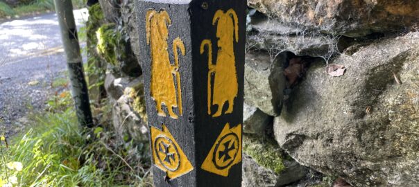
After finishing our sandwiches (or in my case a Dunnes falafel wrap which was quite nice but which I don’t think I’d get it again) we followed the path down into Glendasan. Once in the valley, we joined St Kevin’s Way (you can see his logo in the banner image at the top) and completed the loop back to Glendalough by cutting through the monastic village – parts of which are over 1000 years old.
We were back at the cars in good time, so we said our farewells and sped off back north. I was dropped off in Malahide around 5pm and was back in the flat just a short while before Val returned from work.
We spent a few moments putting the world to rights and catching up in the day’s news. Then for dinner we finished off the beef casserole and then watched some light hearted TV again on Netflix, before calling it a day and retiring, satisfied with our activities, to bed.
Today’s photos (click to enlarge)
 |
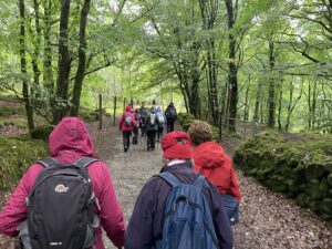 |
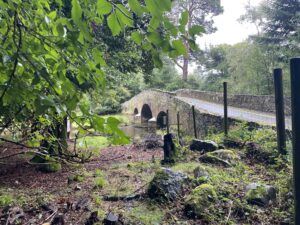
| The Derrybawn Bridge over the Avonmore near the old woollen mills car park – nice to look at, but you can’t get any closer because it’s private land | A wet start for the green road walk up from the Laragh car park to the Upper Lake in Glendalough |
 |
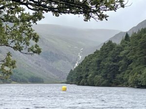 |
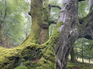
| Misty mossy trees alongside the green road. You might even be able to spot the massive polypore bracket fungus on the left-hand tree | The Upper Lough with the Gleneola river waterfall, near the Miners’ Village, at the far end |
 |
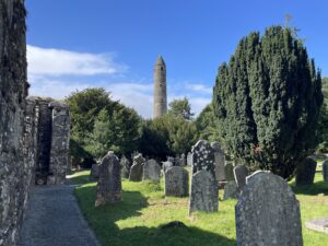 |
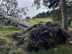
| Huge fallen pine tree at the lower end of Glendasan. The root-ball seems so small in comparison to the bulk of the tree above it that is actually more don’t just keel over when the wind blows! | In St Kevin’s Monastic Village on the way back |
 |
|
| Enjoying the sunshine when it eventually came out at lunchtime. I am still very conscious about that double chin… And who ever thought it was a good idea to photograph yourself with your glasses on your head? | |
Interactive map
(Elevations corrected at GPS Visualizer: Assign DEM elevation data to coordinates )
Max elevation: 225 m
Min elevation: 128 m
Total climbing: 362 m
Total descent: -362 m
Total time: 03:42:25
You can read earlier and later days’ blogs below
Previous day’s blog
Next day’s blog
Ireland home page
 Save as PDF