Ireland day 1065. Wednesday 28 August 2024- Spinc Diversion
| Today’s summary | Val was working in the museum all day so I took the opportunity to drive down to Glendalough to re-recce the Miners’ Track walk I’m leading for friends visiting in September. The main track up the Spinc is going to be closed for repairs so I tested out a diversion route via the Trumonfawdg valley. It turned out well and while the new route is a bit longer and doesn’t have quite the views, it also avoids the worst of the climb up the Spinc itself. So a successful day all round. Watched an old BBC drama “The Hour” over dinner in the evening | ||||
| Today’s weather | Dry and bright with sun in most of Ireland but cloudy with torrential cold downpours in Glendalough. Moderate south westerly wind. Appx 17c | ||||
 |
 |
||||
| Today’s overview location (The green mark shows the location of my route) |
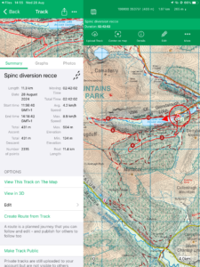
Close-up location (The red line shows where I walked) (Click button below to download GPX of today’s walk as recorded, or see interactive map at bottom with elevations corrected): Spinc Diversion Recce |
||||
Commentary
(Summary blog only. Last full blog was Day 0368).
The best laid plans, and all that..
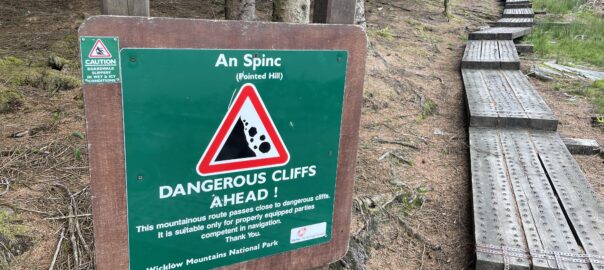
We have friends coming over from America in September and I’m going to take them on a walk round Glendalough. A few weeks ago, I recce’d a route starting at the Upper Lake, then up the Spinc to the ridge then on to Van Diemen’s Land lead mines and back via the Miners’ Track. It was perfect, and we were all set for September. But then, as luck would have it, the National Park decided that the boardwalk section of the Spinc path needed replacing, so the path would be closed for all of the rest of the year. An alternative diversion route was put in place instead.
I knew that for my own peace of mind, I’d need to recce the diversion and today, as Val had been called in to do a full day shift at the Museum, it seemed like the ideal opportunity to head down to Glendalough and give it a try.
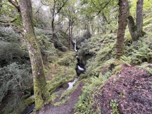
Val was away before 9:30 so I got my things together and jumped into the Trusty Yaris for today’s adventure. I was down at the Upper Lake car park by about 11:30 and set off more or less straight away. I headed off up the Poulanass waterfalls as per the original route, then instead of going to the right, up the Spinc zig-zags, I went straight on and took the diversion which runs round the southern side of the Trumonfawdg valley. It’s an easy forest road and it makes for quick walking, although you can’t see very much because of the trees.
The diversion goes right to the head of the valley, then does a U-Turn part way back down the other side. Eventually you meet a steep stepped boardwalk leading from the left, up to the back of the Spinc. After a bit of sweat and toil, I was soon back on the ridge itself. From there I followed the original route round the top of Glendalough, as per the first recce, without incident. Although the weather wasn’t as good this time. Shortly after I got to the ridge, it started raining and it continued more or less all the way round the Glendalough valley and back to the car. But unlike my disastrous Galtymore hike in July, this time I had my good waterproofs with me, so at least I didn’t get too soaked.
I kept going all the way round the 12km walk without stopping (it took about 2¾ hours), as it was generally too cold and wet to pause. But once back at the car, I changed out of my wet things and enjoyed my lunch at a picnic table during a brief pause in the rain.
The drive back to Malahide went relatively quickly though a bit slow as the M50 was clogged up tonight. Now it’s time to fire up the TV – we’re watching an old BBC drama “The Hour” starring Ben Whishaw – and get the dinner ready. Val had a good day at work and then an enjoyable chat with family in Canada when she got back, so a good day all round today, I think. 🙂
Today’s photos (click to enlarge)
 |
 |
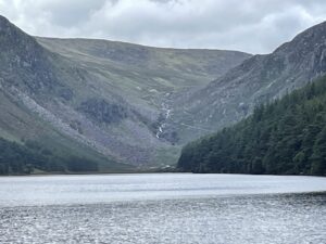
| Looking down to the far end of the Upper Glendalough Lake from the car park. the lead mines, and the apex of today’s walk, are at the end | Poulanass waterfalls |
 |
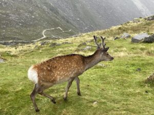 |
| At the top of the Trumonfawdg valley | Tame Red-Sika hybrid deer pottering around the Van Diemens Land mines |
 |
 |
| Enjoying the weather again | On the bridge at the “apex” of the walk and preparing to return to home |
 |
|
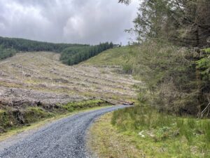
| I followed the red and white dotted diversion route. Perfectly straightforward though a bit tedious walking through the forestry | |
Interactive map
(Elevations corrected at GPS Visualizer: Assign DEM elevation data to coordinates )
Max elevation: 506 m
Min elevation: 134 m
Total climbing: 580 m
Total descent: -581 m
Total time: 02:41:26
You can read earlier and later days’ blogs below
Previous day’s blog
Next day’s blog
Ireland home page
 Save as PDF