
Ireland day 0420. Tuesday 22 November 2022- Powerscourt Waterfall
| Today’s summary | Val had a complete day off work so we went down to have a look at the Powerscourt waterfall, the highest in Ireland. Stopped off in Enniskerry to have a look around and to get a cup of tea on the way back. | ||||
| Today’s weather | Mostly dry with just a bit of drizzle in the morning. Brighter in the afternoon. Light westerly wind. About 7C | ||||
 |
 |
||||
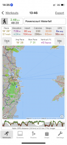
| Today’s overview location (The blue mark shows the location of our route) |
Close-up location (The green line shows where we walked) (Click button below to download GPX of today’s walk as recorded, or see interactive map at bottom with elevations corrected): Powerscourt waterfall |
||||
Commentary
(Summary blog only. Last full blog was Day 0368).
Val had a complete day off both the museum and the castle so after a leisurely morning we drove down to the Powerscourt Waterfall – the highest in Ireland (121 m / 397 ft).
It’s a spectacular spot, set in a hollow in part of the Powerscourt estate now owned by the Slazenger family. We had looked down it several times from the Wicklow Way which runs on a gallery high above but never been in. Being privately owned its quite expensive (€5.50 if you’re over 60) to get in but worth it today as we pretty much had the whole place to ourselves.
Only real disappointment is that there is no café – only a kiosk selling hot drinks to take away. So after walking up both side of the Dargle river to the base of the waterfall, we headed down to Enniskerry for a cup of tea in a “proper” café. And had a look in a weird antique shop along the way. Another enjoyable day out.
Today’s photos (click to enlarge)
 |
 |
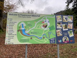
| Site map. Almost incomprehensible | The waterfall. Photos don’t really do it justice |
 |
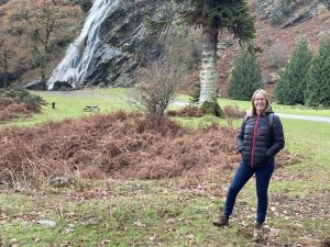 |
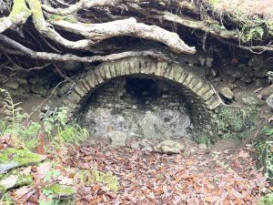
| Ruins of an old ice house | Val in Alpine pose |
 |
|
| Look at those teeth! | |
Interactive map
(Elevations corrected at GPS Visualizer: Assign DEM elevation data to coordinates )
Max elevation: 198 m
Min elevation: 163 m
Total climbing: 158 m
Total descent: -158 m
Total time: 00:48:09
You can read earlier and later days’ blogs below
Previous day’s blog
Next day’s blog
Ireland home page
 Save as PDF