
Ireland day 1412. Sunday 10 August 2025- DEM vs GPS
| Today’s summary | Feeling quite a lot better today so decided to do a scientific experiment to determine whether DEM or GPS altitude is better when recording a walk / run. Tested out on Paddy’s Hill and the answer is that both have advantages and disadvantages. Walked back via the coast and discovered some crinoid fossils. Tea, gin & tonic, and fish finger curry again for dinner. | ||||
| Today’s weather | Dry and mostly overcast with some sun later. Strong southerly wind. Appx 19c | ||||
 |
 |
||||
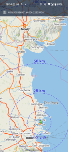
| Today’s overview location (The blue mark shows the location of our route) |
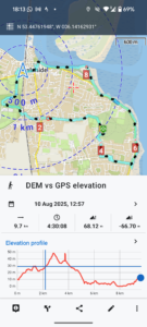
Close-up location (The blue line shows where we walked) (Click button below to download GPX of today’s walk as recorded, or see interactive map at bottom with elevations corrected): DEM vs GPS |
||||
Commentary
I woke up early again but felt quite a little better than I have for almost a week. Accordingly, I was keen to get out and make the most of a largely free day with Val. First though I had to do some more Spanish preparation for tomorrow’s class. I know it sounds like I’m doing a lot of it at the moment, but the class is supposed to be “semi-intensive” and I’ve paid a reasonable amount, so I want to get as much out of it as I can.
Anyway, I soon managed to get the study done and then made porridge and coffee for our breakfast. Then we set off on a quick walk to do what I thought would be an interesting and useful experiment.
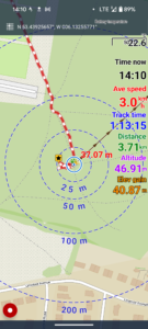
I wanted to compare the location and elevation of the top of Paddy’s Hill, as defined by the highest point in downloaded DEM [Digital Elevation Model] data, and the observed highest point “on the ground” with its GPS elevation measured in real-time.
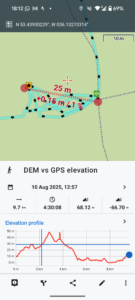
I’ve downloaded DEM data onto my Locus Map app (I believe it’s actually SRTM – Shuttle Radar Topography Model -data) on my Pixel 8 phone, and using it on a walk today up the hill, I found that the DEM “summit” is actually about 20m to the northwest of the observed true summit.
The DEM elevation at that “DEM summit” point is 37.22m and the GPS elevation there is 45.57m. At the observed true summit, on the other hand, while the DEM elevation is lower at 37.07m, the GPS is, as expected, higher at 46.91m.
The moral of the story is: GPS seems to represent the real world more faithfully than DEM, but it’s much “noisier” (ie it bounces around a lot) so total recorded elevation gain on a hike or run is likely to be overstated if using GPS elevations rather than downloaded DEM ones. Also, in this case, I was surprised that the GPS elevation is some 10 metres higher than the DEM elevation. At some point I will have to find a trig point with a known elevation marked on a map, and determine whether the GPS or DEM elevation is closer to the “true” value.
NB it’s important to put the tracker (in my case the Pixel 8 smartphone) on the ground when using GPS to measure elevation. If held at hand-height, it is measuring altitude, which is ground elevation plus the height from ground to your hand. DEM data always measure ground elevation, even if in an aeroplane 10000metres above it.
After fiddling around doing my measurements (and probably boring Val to death in the process – although she showed great forbearance) for about 15 minutes, we walked on down in the direction of Portmarnock and to Dunnes, were we stopped to do some shopping.
Then it was on, down towards Portmarnock promenade, where we picked up a cup of tea in Spar and enjoyed it on the beach. Though it was a bit windswept and chilly down there, so we had to select our spot carefully to get as far out of the wind as we could.
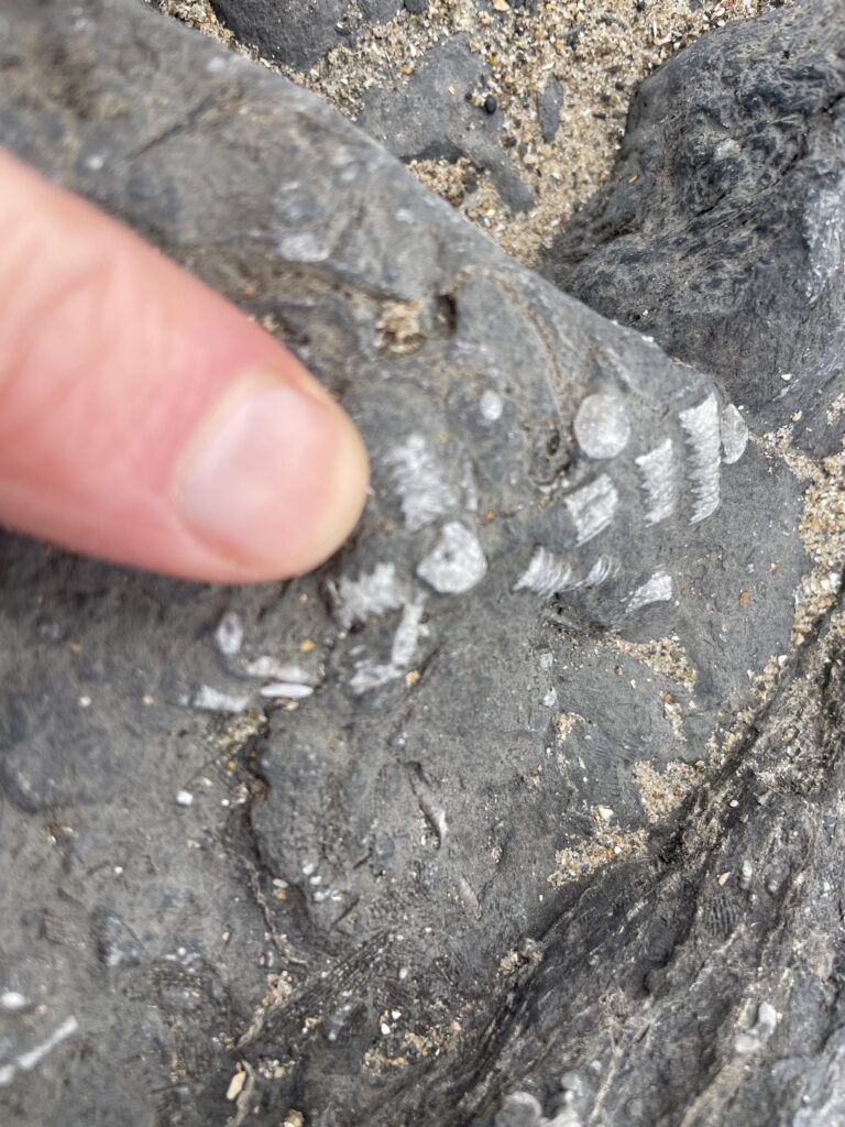
From there, we walked back towards the flat, where, down on the shore, I found some interesting Carboniferous (350ma) crinoid fossils that I’d never noticed before.
A little more shopping was completed in SuperValu then we were back in the flat in time for a cup of tea speedily followed by gins and tonic to get the evening off to a good start. We watched the final two episodes of “Normal People”, which I have concluded is largely self indulgent drivel, and now are seeking something more wholesome to watch. Last night, by the way, we watched the film “Lost in Translation “ starring Bill Murray and Scarlett Johansson. It was charming and heart-warming and a perfect antidote to Normal People.
But before we get to any of that, Val has just made a fish finger curry for dinner, once again. It’s rapidly becoming one of our favourites because it’s just so delicious. So I’m going to sign off now to go and enjoy it while it’s still hot. Thanks Val, once again!
(PS I’ll do the washing up)
Today’s photos (click to enlarge)
 |
 |
| The observed summit of Paddy’s Hill. The red number in the middle of the screen is the DEM elevation, from the map. Whereas the purple elevation at the right is the GPS elevation measured by the device in real time. The GPX file you record can use either the DEM or GPS elevation – with the Locus Map app on the Pixel phone you can choose either. I normally use DEM despite it not being quite as “accurate” as GPS, because it’s much less “noisy” and so is much less likely to overestimate total elevation gain. NB you can also use barometric altitude alternatively, but I find that to be absolutely hopeless unless recording an activity only a few minutes long. Any longer than that and natural air pressure changes – e.g. depressions and anticyclones – swamp out elevation changes recorded by the movement of the device | The “DEM summit” of Paddy’s Hill – i.e. the point where the DEM altitude as drawn from the map is highest |
 |
 |
| The DEM summit (left) and GPS summit (right of Paddy’s Hill, with the measured distance separating them | Our current go-to store for posh shopping |
 |
 |
| Refreshments on the beach! | Lunch, anyone? |
 |
|
| Crinoid (a type of echinoderm) fragments, fossilised in the 350 million year old Malahide sandstone (which also contains the presumably contemporaneous Lithostrotion coral, as well as brachiopods) | |
Interactive map
(Elevations corrected at GPS Visualizer: Assign DEM elevation data to coordinates )
Max elevation: 50 m
Min elevation: 0 m
Total climbing: 125 m
Total descent: -125 m
Total time: 04:30:08
You can read earlier and later days’ blogs below
Previous day’s blog
Next day’s blog
Ireland home page
 Save as PDF