Ireland day 1359. Wednesday 18 June 2025- Waypoints
| Today’s summary | Val still away so after a morning trying out various mobile phone technologies I had lunch then ambled down the coast to Howth. On the way I tested out Locus photo waypoints on my Android phone, which worked OK. Fish and chips at Leo Burdock’s in Howth at the end. No need for dinner! Dart and bus back then an evening of travel vlogs once back. | ||||
| Today’s weather | Bright breezy and dry. Moderate south easterly wind. Appx 18c | ||||
 |
 |
||||
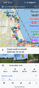
| Today’s overview location (The blue mark shows the location of my route) |
Close-up location (The blue line shows where I walked and the thumbnail pictures are the waypoints) (Click button below to download GPX of today’s walk as recorded, or see interactive map at bottom with elevations corrected): Howth via coast with Waypoint test |
||||
Commentary
When Val’s away I’m inclined to waste hours fiddling around with bits of usually incompatible technology trying to make them do things they don’t want to do. That is of course exactly what I did this morning.
Today I wondered what what would happen if I connected my android phone to my iPhone with a USB cable. The answer was moderately interesting – if you like that sort of thing. I found that my Android phone would work as an external battery for my iPhone and start charging it up (but not vice versa). And my Android phone could read photos from the library on my iPhone (but not vice versa). I’m sure at some point these might be useful features although I can’t quite imagine when that might be. I just need to remember to carry all the requisite cables.
Having wasted most of the morning fiddling about, I got a quick breakfast – basically fresh strawberries, rhubarb tart and ice cream. Eccentric, I know, but that’s what happens when husbands are left unattended for any length of time.
Eventually, it was time to go out and do something constructive. Yesterday, in the course of testing my iPhone Locus Lite app, I’d experimented with the “photo waypoint” feature. It was moderately useful so I thought I’d try it out on the Android version today. I selected a coastal walk to Howth as a suitable route to give it a good test, so equipped with all my electronics, I set off without further ado.
The route, at least, turned out to be an excellent choice. The weather was, for once, benign and it was t-shirt and shorts the whole way.
I added a number of Locus photo waypoints to my app along the walk and the process seemed to work ok, if a little tedious. If the weather had been more “normal” – i.e. cold wet and windy – I imagine it might be a bit too fiddly to be worth bothering with. Also, I wasn’t sure exactly why I might want to add photos to my walks as they are difficult to share with anyone else (the photos don’t transfer when the track is synced with Strava).
The final problem I encountered was in getting the photos taken via the app off my phone. They aren’t stored in the normal photos (DCIM) folder and it took me quite a long time to work out where they actually were. After doing some online research, I discovered they were hidden in an obscure Android subfolder on my phone, which was only accessible with a special app called “FV File Explorer”. Once I knew what I was doing, it was all pretty straightforward. It just took rather a long time to get to that point.
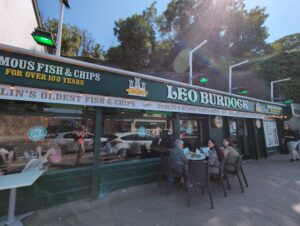
Much as I enjoyed the walk – the sunshine and technology were after all very beguiling – the best part came at the end. Leo Burdock’s fish and chips beckoned and I simply couldn’t resist the temptation of salt, grease and vinegar. My only defence is that I had walked quite a long way to get there, fuelled only by strawberries. So perhaps the net health impact won’t be too life-threatening.
When I’d finished my fishy feast, I caught a DART and then a 102 bus back to Malahide. I spent the rest of the evening drinking tea and not eating, and, being in an abstemious frame of mind, I also resisted the temptation to test out any more technological innovations. Finally I watched a couple more travel videos (I’m having a bit of an Azores theme at the moment) before I called it a day and went to bed to dream of USB cables and wireless synchronisation.
Today’s photos (click to enlarge)
 |
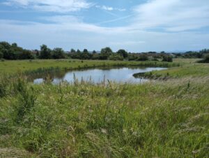 |
| I came across this unusual toadstool growing in the playing fields on Paddy’s Hill. I have no idea what caused the peculiar patterning. All the nearby toadstools had smooth caps – this was very much the odd one out | Malahide’s “secret” lake on the flanks of Paddy’s Hill. Not many people actually know it’s there, but you can access it from the Jameson orchard estate. I tried to exit via the school playing fields, but the gates were locked shut. So I had to retreat back the way I had come. |
 |
 |
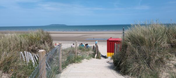
| Those trees growing in the glacial till on the Burrow beach just seem to be more getting precarious every day | Just made it round the headland from the Burrow beach to Howth before the tide came in |
 |
 |
| Journey’s end! | Won’t need to eat again until 2027 |
 |
|
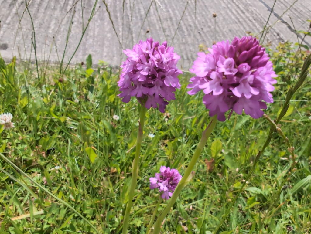
| More of those pyramidal orchids. Loads of them this year! | |
Interactive map
(Elevations corrected at GPS Visualizer: Assign DEM elevation data to coordinates )
Max elevation: 49 m
Min elevation: 0 m
Total climbing: 158 m
Total descent: -161 m
Total time: 03:28:03
You can read earlier and later days’ blogs below
Previous day’s blog
Next day’s blog
Ireland home page
 Save as PDF