Ireland day 0291. Saturday 16 July 2022- Carrickgollogan
| Today’s summary | Val was at work so I took the DART down to Shankill and walked up the Dublin Mountains Way to Carrickgollogan Hill then down to explore the Ballycorus leadmines chimney with the curious external spiral staircase. A fascinating day out | ||||
| Today’s weather | Dry and bright. Long sunny intervals in the afternoon. Light southwesterly breeze. Feeling comfortably warm. Appx 22C | ||||
 |
 |
||||
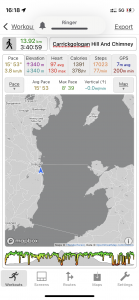
| Today’s overview location (The blue mark shows the location of my route) |
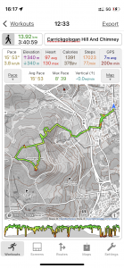
Close-up location (The green line shows where I walked) (Click button below to download GPX of today’s walk as recorded, or see interactive map at bottom with elevations corrected): Carrickgollogon and Ballycorus chimney |
||||
Commentary
As we were sitting on the top of Killiney Hill in the shadow of the obelisk yesterday, we spotted a strange tower-like structure sticking out of the top of a hill to the south of the city, close to the M11 motorway. After a bit of trigonometry on my map, I worked out that it was probably actually the ancient chimney at the now-defunct Ballycorus lead mine on Carrickgollogan Hill. At the time I thought that it looked interesting and worth an exploratory visit.
As it happened, Val was at work all day today and I was left to my own devices, so I thought that now might be as good a time as any to go down and have a look. I worked out that it was possible to get up there on a “proper” Long Distance Path – the Dublin Mountains Way – which runs from Shankill in the east some 40km / 25mi to Tallaght in the west. Even better, Shankill is on the DART line so is directly accessible from Malahide.
Despite the relative ease of getting there, I didn’t organise my journey very well this morning. I had a few technology problems to contend with (basically – batteries that wouldn’t charge up) so was later leaving the flat than I had planned. Then once I had ambled down to the station, I found that the next train wasn’t for 38 minutes, so I had a long wait on the platform. But at least for once the sun was shining and it wasn’t a Baltic experience! Although just to make matters worse, when the train did turn up I discovered that it terminated at Connolly so I had another tedious wait for a connecting DART to take me on the final leg of my journey down to Shankill.
The upshot of all this was that it was 12:30 before I was ready to set out along the Dublin Mountains Way and begin my voyage of discovery. The actual start of the path is supposed to be on the high street in Shankill but my various maps all show different exact termini. I followed my nose and a couple of signs and was soon out of the town and heading up a broad gravel path up into the Carrickgollogan woods. There are numerous small paths branching off the main route, heading off into the trees. They looked tempting to explore, but as I was about to venture up one of them, a mountain biker shot out so I thought the better of it. Looking a bit more carefully at my map I realised that they were indeed off-road biking trails, so definitely best avoided by those on foot.
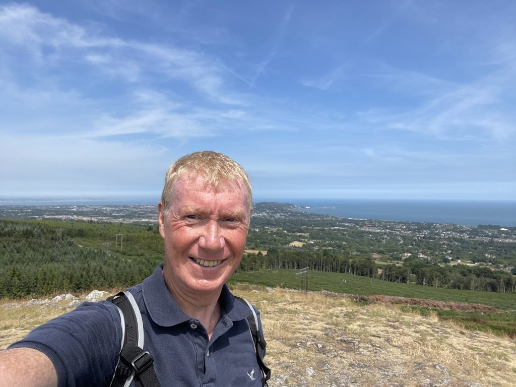
The pathway winds upwards and eventually you leave the forest and the summit of Carrickgollogan Hill rises as a perfect little dome ahead of you. I followed the path which zigzags up the side and was soon on the top, admiring the view in the uncharacteristically warm breeze. The wind was quite welcome, actually – both for its cooling effect but more especially because it dispelled the cloud of flies which seemed to have followed me up out of the trees.
I found a sunny spot with a bit of air movement and had a leisurely lunch while I admired the expansive view in all directions. Eventually, as time was marching on, I stirred myself and dropped back down, then skirted round to the west of the woodland to reach the lead mine chimney which had been the original object of my mission.
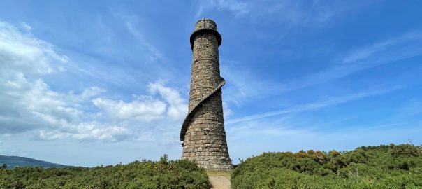
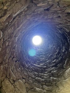
It’s an impressive sight even when you see it from far-away Killiney Hill, and when you get up close it’s even more imposing. It’s made of seemingly indestructible granite, and has a peculiar spiral staircase up the outside which reminded me a bit of that at the Wonderful Barn near Castletown. What’s more, there’s even an entrance portal so you can go inside and gaze up through the chimney to the distant circle of blue sky hovering at the top.
There was actually a lead ore “quarry” here, and also an underground mine, but the chimney isn’t directly related to the mine workings. Rather, the lead ore was transported down into the valley where it was smelted to release the metal. The chimney is part of an elaborate flue mechanism designed to trap and condense lead-containing vapours from the smelter, to which it was connected by a 2km / 1mi pipe. You can read more about the morbid consequences of this process in the photo captions below.
The lead mines up on the hill closed in the 1860s but the smelter down in the valley kept operating for several more years – treating lead ore at first from the Wicklow mines (you can see them in the Glendalough and Glendasan valleys) and then, later, from a mine on the Isle of Man. It finally closed completely in 1913.
I had a good look round – and made sure I could see the obelisk on Killiney Hill, from where we had first spotted the chimney, looking in the reverse direction. From there I retraced my steps and was back at the DART station by about 4:30. My travel arrangements worked much better this evening. A direct DART to Malahide came through only five minutes after I arrived, and I was back in the flat in Malahide in under an hour.
I thought this was a thoroughly enjoyable walk, with some excellent scenery, outstanding views, and a bit of industrial archaeology thrown in too. I continue to be amazed how many of these fascinating sites are within just a stone’s throw of the capital city. Dubliners don’t know how lucky they are!
Today’s photos (click to enlarge)
 |
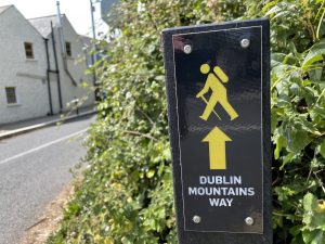 |
| The exact start of the Dublin Mountains Way is a bit obscure but this was the first sign I saw – just outside Shankill DART station. | The route is mostly well signposted – except at a couple of key junctions, where it isn’t. A bit of trial-and-error was required to find the actual route |
 |
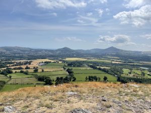 |
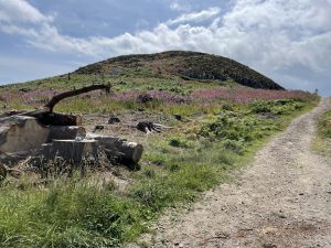
| Looking up to the top of Carrickgollogan Hill. It’s 276 m (906 ft) high and the views from the top are outstanding – unimpeded vistas to the far horizons at all four points of the compass. An excellent destination for a rewarding hill climb – yet even though it was the weekend, and despite the excellence of the views, the benign weather, and the proximity to Dublin, there were very few people about today. I really enjoyed it. | Looking south from the top to the omnipresent Great Sugarloaf (the peak on the right) and the Little Sugarloaf (on the left) |
 |
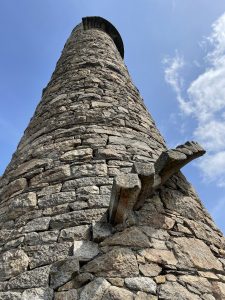 |
| Down at the Ballycorus lead mine chimney. We had spotted it from the Killiney Obelisk yesterday, and it was satisfying to reach it today. The history of the chimney is fascinating. In summary, there was a lead smelting works down in the valley (at Ballycorus) and it was discovered that lead could also be extracted from the exhaust gases if they were passed along a long pipe – the lead condensed on the inside. So a 2km / 1mi flue was built from the valley which terminated at the chimney on the hill. Then men were sent in to the flue from time to time to scrape the lead off – unsurprisingly many suffered from lead poisoning and subsequently died – so the surrounding area is sometimes known as Death Valley. The chimney was built in 1836 and the smelter eventually closed in 1913. I don’t know if the manual recovery of lead continued right up to that time. You would rather hope that it didn’t. |
There is a curious external spiral staircase which goes up to a viewing platform at the top. The lower steps have been removed to stop you going up – fortunate because there’s no handrail to stop you falling off. Apparently the chimney originally extended quite bit a higher than it does today – there was a brick flue going up further beyond where the viewing platform is located. |
 |
|
| On the top of Carrickgollogan Hill, looking east. If you zoom right in you might just be able to see a tiny white mark just below the horizon to the right of my head. That’s Sorrento Terrace, in Dalkey, which we visited yesterday. | |
Interactive map
(Elevations corrected at GPS Visualizer: Assign DEM elevation data to coordinates )
Max elevation: 259 m
Min elevation: 17 m
Total climbing: 422 m
Total descent: -423 m
Total time: 03:40:51
You can read earlier and later days’ blogs below
Previous day’s blog
Next day’s blog
Ireland home page
 Save as PDF