
Ireland day 0257. Sunday 12 June 2022- Waterstown
| Today’s summary | Took buses to Palmerstown, on the west of Dublin, for walk round Waterstown Park with Dublin Walking Club. An easy, sociable day out while Val was at work | ||||
| Today’s weather | Mostly dry but with occasional light showers. A bit of sun in the afternoon. Moderate blustery westerly wind. About 15C | ||||
 |
 |
||||
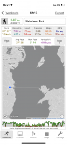
| Today’s overview location (The blue mark shows the location of our route) |
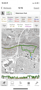
Close-up location (The green line shows where we walked) (Click button below to download GPX of today’s walk as recorded, or see interactive map at bottom with elevations corrected): Waterstone Park from Palmerstown |
||||
Commentary
On Sundays, the Dublin Walking Club usually runs a short social walk somewhere in the environs of the city, and normally it’s somewhere that is easily accessible by public transport. So I was a bit surprised to see on the programme that today’s walk was at “Palmerstown”, because the big stately home and estate at Palmerstown is a good 50 km / 30 miles outside Dublin, well to the south west. I had resigned myself to driving there as it’s not easy to get a bus there on a Sunday morning. I was just about to set off when I thought I better check the programme a bit more carefully to make sure I’d actually got everything right.
When I read the programme properly, I saw that it said we should meet at “Palmerstown House” prior to a walk round Waterstown Park. I thought I would just have a look on Google Maps to see where the Park was, so I could assess how far the walk from Palmerstown was likely to be. In fact it turned out to be 27km / 17mi away which I thought was an improbably long way for a short Sunday walk. So I looked a bit more carefully at my map and discovered that as well as being a large country estate near Naas, Palmerstown is also the name of a suburb of of Dublin, just inside the M50. And Waterstown Park is right in the middle of this other Palmerstown, on the banks of the Liffey. More to the point, Palmerstown House is the name of the village pub, and not a large manor house in the country.
With these geographic difficulties cleared up, I realised I could get there by bus, which as well as being good for my carbon footprint(!), would also be cheaper – given that petrol is touching €2.20 a litre now (it was €1.30 when we first came to Ireland). Plus the M50 toll could be avoided. And also, I think the bus is cheaper and generally more fun than the DART. So I put my bus-ology skills into practice, and worked out I could get there in just over an hour, courtesy of the 42 and the C3.
Once Dublin Bus had worked its magic and successfully delivered me to the Palmerstown House (pub), we met up and headed out into Waterstown Park. I should add by the way, in case you were wondering, that Palmerstown got its very English sounding name courtesy of the local religious leader Ailred who made pilgrimages to the Holy Lands around the year 1185AD. It was customary for people returning from these pilgrimages to bring back with them a palm leaf, so Ailred became “Ailred the Palmer” and the town was named after him. There has been some debate about the spelling of the town and indeed various referenda were held in the early 2000s about whether it should be “Palmerston” or “Palmerstown”. They were inconclusive and today it seems that both spellings are in circulation.
I’d never been to Waterstown Park before, and very much enjoyed my first visit today. It’s quite a big park, running alongside the south bank of the Liffey. Being a bit less central than some of Dublin’s other major parks, it’s quite quiet (though apparently it was packed during the lockdowns, as it was within the 5km exercise limit of quite a large proportion of Dublin’s population). It was privately owned farmland until it passed into the ownership of the council in the 1980s.
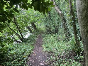
The western boundary of the park runs underneath the M50 flyover but we found a way though the perimeter fence and followed a rough path upstream and under the bridge. Apparently, it’s an old angler’s path and it runs along the top of the embankment separating the Liffey from a parallel mill race which runs to the south of it.
We had intended to follow the path as far as it goes, which is probably the Wren’s Nest Weir. But it’s very overgrown and soon we were fighting through a tangle of thorns, roots and mud and so when we eventually got to a large fallen tree completely blocking the path, we called it a day and stopped to have lunch. While we were focused on our dining arrangements, one of the party happened to look up and spotted a flash of turquoise darting along the river bank. Almost certainly a kingfisher! I missed it sadly, so have resolved to go back soon to see if I have better luck – and maybe press on past the fallen tree and see if I can get to the weir.
We made our way back into the park proper, and had a quick walk round, spotting en route a couple of buzzards hovering over the opposite bank of the river (locally known as the Strawberry Beds). Apparently there are three nesting pairs living in the pine trees over there. Sadly, there wasn’t time for a drink at the end so I bypassed the pub and made my way back to the bus stop. I successfully reversed my journey to Malahide – this time I went via the 26 and the H2, to vary things a little. I do like the bus journey back, I must admit, as you get a good view and it’s quite soporific. A great opportunity to reflect on a good day out – despite the missed kingfisher – while I struggled more or less successfully to stay awake.
Today’s photos (click to enlarge)
 |
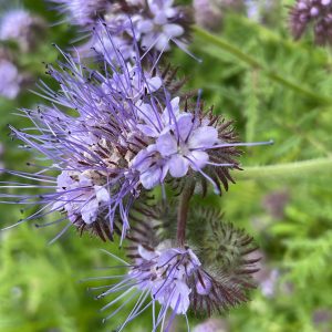 |
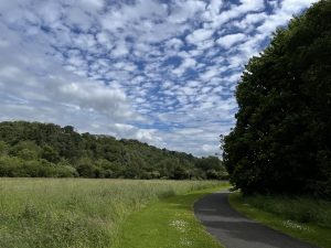
| In Waterstown Park. I’m not sure if that’s a mackerel sky, but it started raining soon afterwards | This curious blue flower had been planted abundantly in the wildflower beds in the park. I’m not sure exactly what it was, but it was covered in honey bees and bumble bees. It could be Fiddleneck or Purple Tansy, Phacelia tanacetifolia. If it is, it’s a member of the borage family and is often planted as “green manure” as well as being a pollinator attractant |
 |
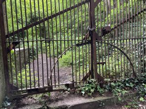 |
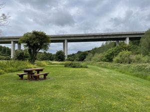
| I’ve driven over this dozens of times – it’s the toll bridge on the M50 orbital motorway. I’d often wondered what the green area below it was – and now we know. It’s Waterstone Park | If you walk under the motorway you end up on a hidden and overgrown path which leads up the Liffey, sandwiched between the bank of the river on the right hand side, and the mill race goyt on the left. It’s quite an interesting spot to explore. This is a locked off bridge over the goyt – who knows where it leads but we weren’t quite brave enough to squeeze through the gap in the bars to find out |
 |
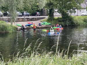 |
| Looking back the way we had come on the “hidden” path. In this picture, the Liffey is on the left | Back in the park, on the banks of the Liffey. Canoeists were out in force today, practicing their eskimo rolls with varying degrees of success. Fortunately the Liffey is so shallow and slow moving that the instructor could simply stand on the bottom and turn the hapless mariners the right way up if they failed to make it upright of their own accord |
 |
|
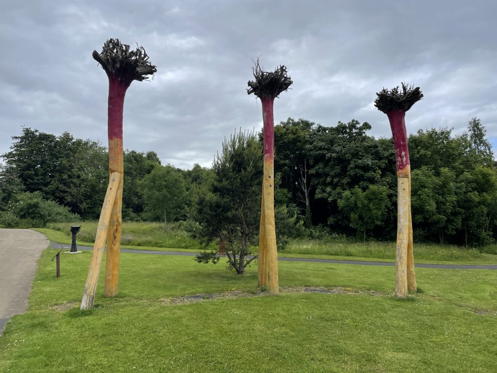
| Curious upside down trees in the park. I have no idea what they are supposed to be but doubtless someone was paid a lot of money to create them. | |
Interactive map
(Elevations corrected at GPS Visualizer: Assign DEM elevation data to coordinates )
Max elevation: 48 m
Min elevation: 10 m
Total climbing: 156 m
Total descent: -157 m
Total time: 03:03:02
You can read earlier and later days’ blogs below
Previous day’s blog
Next day’s blog
Ireland home page
 Save as PDF