
Ireland day 1577. Thursday 22 January 2026- Stuttgart
| Today’s summary | Got up then went for a swim in the hotel pool as soon as I’d had breakfast. Then devised an 8km looped walk from Bad Wildbad through the Black Forest hills around nearby Sommerberg. Went out to walk it about 12:30 and it took about 3 hours including a stop for picnic lunch at a view point. Absolutely brilliant. Returned to the hotel about 3:30pm. Dropped my walking gear off and went up to supermarket to get dinner for later. Then once I was back I spent a couple of hours in the pool and sauna and got a snack in the Bistro. Videocall with Val in the evening. All well with her. | ||||
| Today’s weather | Dry bright and sunny. Hardly any wind. Appx 4c | ||||
 |
 |
||||
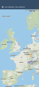
| Today’s overview location (The blue mark shows the location of my route) |
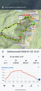
Close-up location (The blue /green line shows where I walked) (Click button below to download GPX of today’s walk as recorded, or see interactive map at bottom with elevations corrected): Schwarzwald |
||||
Commentary
Today was the last full day of my mini-break in Germany and I was determined to make the most of it. So I was up and about and in breakfast by soon after 8am. There was plenty of choice at the buffet, so I didn’t rush. I was relieved to note that there were several other patrons there as well as me. So I have been able confidently to banish the passing nightmare I was occasionally entertaining, of being the only guest in a vast old and otherwise deserted hotel
As I was lingering over my Frühstück, I used my Locus map app to devise a walking route for later in the day. I wanted to get a bit of a feel for my surroundings, as I’d never been to this part of the world before. I thought a walk in the Schwarzwald (Black Forest) would be a good plan, so devised an 8km loop that would take me up into the hills and back through the trees.
Once I’d eaten as much muesli as I could reasonably digest, I decided that before embarking on my hike, I’d have a relaxing swim in the hotel pool. Well, it turned out to be so relaxing that I wasn’t actually ready to head off into the hills until nearly noon.
But once I did get going, it turned out to be a perfect walk. Beautiful clear skies, cold but not bitter, and brilliant sun. My app had chosen some really interesting and less well-used paths, and I saw nobody at all the whole time I was out. It was blissfully quiet everywhere, and the sun filtered through the trees creating a really quite sublime effect.
Midway round, the views opened up a little and I found a sunny bench with a view which was the perfect spot for my lunch. Just a few leftovers from last nights dinner, but enough to carry on where the muesli left off.
After lunch, I headed down into the Enz valley, walking down the Walter Speer weg which, for some reason, my Locus maps app had selected for me to follow. It felt like nobody else had been that way for a long time and I’m pretty sure I would have been the first to walk it this year. It was a bit tricky to find the route in a couple of places but that just added to the general sense of adventure.
Walter and his weg eventually pitched me into a park close to the centre of the town. From there it was just a short hop across the river Enz (not a literal hop I should add) and a quick stroll down the Kernerstrasse and I was back at the hotel for about 3pm.
I went back to my room to drop off my hiking gear, then set out again, this time to go to the supermarket and Konditorei to get something to eat for dinner.
Once I’d done all that, and also dealt with a couple of admin matters that had cropped up during the day, I thought it was time to go back to the pool and sauna and resume my relaxation programme. In the end, I spent most of the evening immersed in warm water, though I did take a halftime break to go to the bistro for a coffee and a cake.
Finally I made it back to my room, where I had my dinner and a beer which felt particularly well-earned, and then video called Val in Switzerland. I’m pleased to report that she’s enjoying her holiday as much as I am mine, though (unsurprisingly) she’s finding the cross country skiing quite tiring. I suspect she will be coming home for a rest!
Well that’s it for today. Really a day it remember. Truly fantastic.
Today’s photos (click to enlarge)
 |
 |
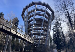
| For a moment I thought I was as County Wicklow! But no – this was the Aussichtsturm Baunwipfelpfad at Sommerberg. An alpine treetop walk – with a slide – just like the one at Avondale | In the woods on the Sonnerberg “plateau”. The sunny bench made an ideal spot for my picnic lunch |
 |
 |
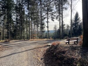
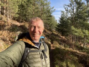
| I was really in my element on this walk. Thoroughly enjoyed it | Another seat with a view – on the hillside on the way back down, overlooking Bad Wildbad and the Enz Valley |
 |
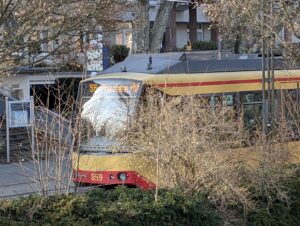 |
| Bridge over the Enz, back down in Bad Wildbad. It’s very dry here at the moment, so the river level was quite low | No report of my travels would be complete without a picture of a train. This is the train to and from Pforzheim – the one I caught yesterday in fact – in the terminus station at Bad Wildbad Kurpark |
 |
|
| I guess this counts as a train, too, really. It’s the Sommerberbahn funicular which goes every hour or so up to the top station in the Sommerberg settlement itself. I thought about taking a ride but concluded I needed the exercise so decided to walk up instead. Actually it was a very nice walk, and the weather was perfect for it too. | |
Interactive map
(Elevations corrected at GPS Visualizer: Assign DEM elevation data to coordinates )
Max elevation: 776 m
Min elevation: 426 m
Total climbing: 478 m
Total descent: -479 m
Total time: 02:54:03
You can read earlier and later days’ blogs below
Previous day’s blog
Next day’s blog
Ireland home page
 Save as PDF