Ireland day 1482. Sunday 19 October 2025- Malahide Walk
| Today’s summary | We took the train with our friends to Balbriggan this morning then walked along the coast to Laytown. Very wet everywhere after heavy overnight rain which also lasted all morning. Several streams were in spate so quite hard to cross. Finished at Laytown just in time to catch the 1551 train back to Malahide. Tea and cakes in the flat then Townyard restaurant for dinner | ||||
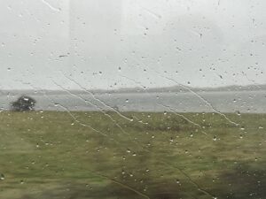
| Today’s weather | Torrential rain all night and all morning. Lighter rain from noon onwards then even a few rays of sun in late afternoon and evening. Gale force south easterly wind in the morning, calm by evening. Appx 15c | ||||
 |
 |
||||
| Today’s overview location (The blue mark shows the location of our route) |
Close-up location (The blue line shows where we walked) (Click button below to download GPX of today’s walk as recorded, or see interactive map at bottom with elevations corrected): Balbriggan to Laytown 4 |
||||
Commentary
Our Dingle trip has finished, but our friends are staying with us for a couple more days, so we still feel to be in the holiday mood. Even the torrential rain which lashed down all night and most of the morning couldn’t dampen our spirits. We had decided yesterday on the drive back that we’d like to do a coastal walk near Malahide today, so despite a few misgivings about the weather, I suggested we did what has lately become one of my favourite go-to local walks. Balbriggan to Laytown, with train to and from the start and finish. Rail connections are a bit limited on Sundays, but there was a departure from Malahide at 11:35 and we aimed to catch that.
First, though, there were packed lunches to be made and breakfasts to be eaten. Then we packed our bags with all the waterproofs that we hadn’t needed in Dingle, and caught the train.
As soon as we arrived in Balbriggan, we found ourselves in the midst of a particularly heavy spell of rain, so before we went anywhere, we crowded into the platform’s waiting shelter and pulled our waterproof jackets and trousers on.
The tide was in when we set off and that, combined with the rain which had caused several of the streams and rivers to flood, made it quite a challenging route. Luckily, I was pretty confident we would be able to get round without difficulty, having done this walk three times already this year, in all states of the tide. And indeed we did complete the walk without too much difficulty. We had to paddle across streams at a couple of points, and make death-defying leaps from one bank to the other, but remarkably we mostly ended the day with dry(ish) feet.
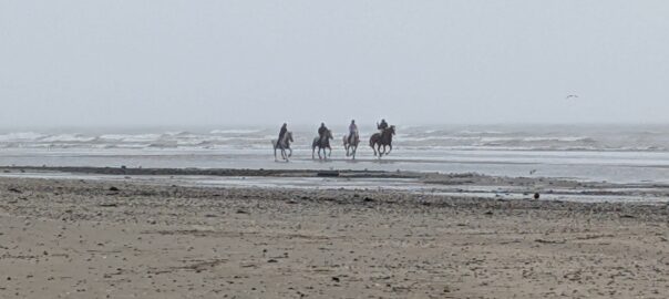
I particularly enjoy this walk because it’s pretty inaccessible, especially in the southern section. So the isolation plus the poor weather ensured we had much of the beach just to ourselves for a lot of the way. Though we did come across four horses out for a canter on the sands near Gormanston. I’ve never seen horses there before, though they do of course race at Laytown itself, a short way further up.
We had lunch near the rail viaduct at Gormanston, then completed the walk comfortably in time to catch the southbound train at Laytown at 15:51. We were back in the flat by 4:30pm, which gate us plenty of time to get a cup of tea, have a bite of cake, get changed and even watch some of last year’s Tour de France on Netflix before embarking on the next stage in our activity plan for the day.
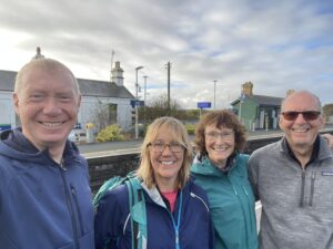
So finally, the four of us went out at 7:30 to spend the rest of the evening in the “Townyard” restaurant, enjoying dinner courtesy of Bev and Pete. What an wonderful treat – gratefully received, and the perfect way to round off an excellent, element-defying, day out.
Today’s photos (click to enlarge)
 |
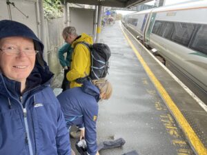 |
| Rain lashing down on the 11:35 from Malahide. All too soon we were off the train and exposing ourselves to the full force of the elements | Here we are at Balbriggan, donning full rain protection gear |
 |
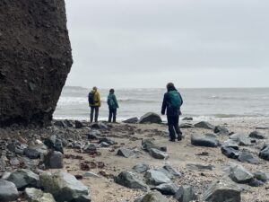 |
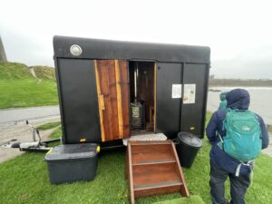
| A pop up mobile sauna has just appeared in a trailer a short way north of Balbriggan. It’s a really popular trend though sadly as far as the owner was concerned, there were few patrons about today, in view of the weather | Rounding one of the many headlands on the more rocky section of the walk south of Gormanston |
 |
 |
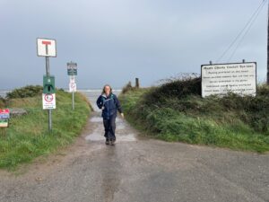
| Val striding purposefully towards Laytown station at the end | Made it! And just look at the blue sky! |
 |
|
| There’s a small stream, just visible on the map, which cuts the beach midway between Gormanston and Laytown. Normally it is possible to cross it close to where it meets the sea. But after last night’s rain, it was too deep and fast today so I used my Strava heat-map to locate a bridge a little upstream, close to the small railway viaduct. So we were able to get to the other side with dry feet intact. | |
Interactive map
(Elevations corrected at GPS Visualizer: Assign DEM elevation data to coordinates )
Max elevation: 13 m
Min elevation: 0 m
Total climbing: 129 m
Total descent: -134 m
Total time: 03:36:53
You can read earlier and later days’ blogs below
Previous day’s blog
Next day’s blog
Ireland home page
 Save as PDF