Ireland day 1462. Monday 29 September 2025- Gran Canaria 5
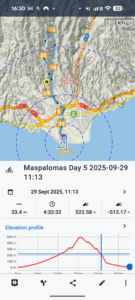
| Today’s summary | Borrowed bikes from the hotel and did a 34km looped cycle ride up into the interior of Gran Canaria on the GC504 / 503. First did the ride in 2018 and enjoyed it just as much this time, even if it was hard work. A tough 500m climb midway but successfully made it to the top without having to get off and push. An exhilarating sweep back down the hill at the end, the only disappointment being that the lovely “Labrador” restaurant in Montana la Data had closed down. Refreshments in a café near the end then relaxed on our balcony back at the hotel. I went for a quick sauna, like yesterday, then we had dinner in the hotel restaurant just as it was getting dark | ||||
| Today’s weather | A bit of cloud in the morning but otherwise dry sunny and warm all day. Moderate north easterly wind. Appx 27c | ||||
 |
 |
||||
| Today’s overview location (The orange mark shows the location of our route) |
Close-up location (The blue line shows where we walked) (Click button below to download GPX of today’s walk as recorded, or see interactive map at bottom with elevations corrected): Maspalomas Day 5 |
||||
Commentary
As you get older, you begin to worry about losing fitness and no longer being able to do the things you used to be able to do. So from time to time you set yourselves comparative tests. Can do that thing I did a decade ago as fast as I used to? Can I still even do it?
Well today we had the ideal opportunity to do some research on exactly this problem.
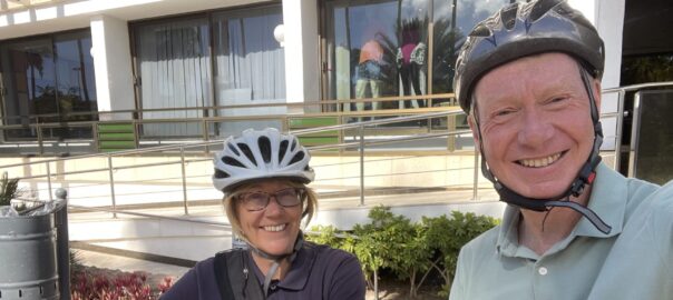
Seven years ago – November 2018, to be exact, when we were last in Gran Canaria, we had hired bikes from our hotel and done a good 34km circular bike ride into the interior of the island. It included an ascent up one of the many steep hill-climbs for which the western Canaries are known. So we were delighted (in a morbidly fascinated sort of a way) to discover that not only did the hotel we are staying in this time have bikes for hire, but they were free.
So today was the day to do a back-to-back test. Could we still get round this fairly challenging loop with as much ease as we did last time?
By way of preparation, we started the day with a good energy-boosting breakfast, and were pleased to see that the morning was a bit cloudy (the shade didn’t last though). After we had eaten, we spoke to the concierge who retrieved a couple of bikes from the basement, and we’re ready to go.
The bikes were very solid – a bit like the hire bikes you might see it Dublin or London – so were quite hard to ride quickly. But at least they seemed unlikely to break, and they did have seven gears.
Fortunately I had recorded a GPX of our route the last time we rode this way, which was a good thing because the way out of Maspalomas is not at all obvious and involves going round several roundabouts seemingly the wrong way. I think the town planner must have done their training in Hemel Hempstead.
Eventually we escaped the urban sprawl and once we were under the motorway and into the countryside, the going was a lot more pleasant. We headed inland along the GC-504 road, gently climbing up a narrow valley, enclosed by the most beautiful bougainvillea hedges imaginable, and alongside orchards of mango, avocado, orange and pomegranate. Stunning.
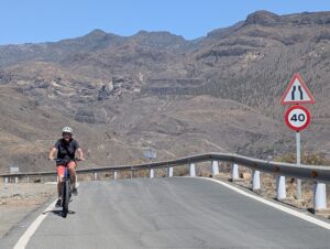
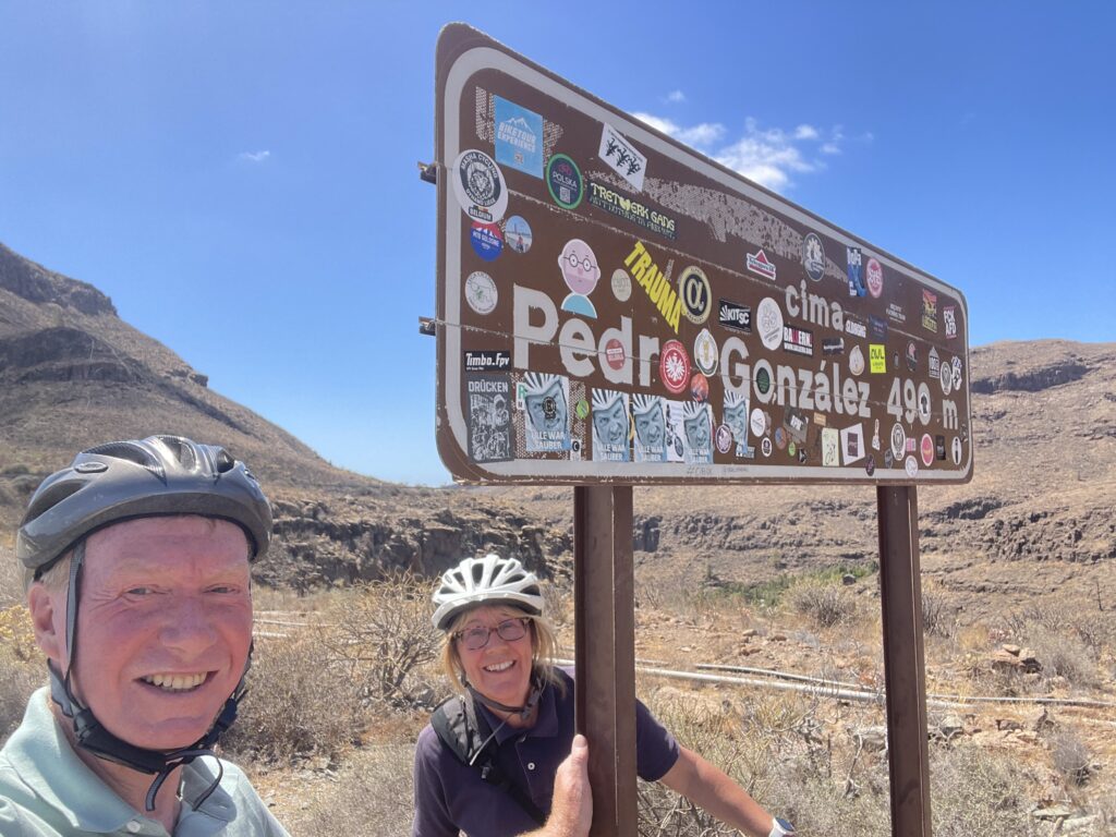
Once we reached Ayaguares at the head of the valley by the dam, the road turned to the left, transformed itself into the GC-503, and began to climb steeply. After what seemed like a hundred switchbacks and hairpins, we eventually made it to the top. A spectacular mirador with views down into the next valley, with the “Palmitos” theme park at the top.
After pausing to admire the view (code for “breathe”) we cruised down the ridge, swooping down through some very up-market residencias, as spectacular views opened up to the south, with Maspalomas and Playa del Inglés straight ahead.
The only disappointment of the whole excursion was that the Restaurante Labrador, which we had enjoyed the last time, was closed. In fact it looked like it had shut down several years ago.
So we sailed on past, back into the outskirts of Masapalomas where we found a suitable cafe – Mediterráneo – in an area called Sonnenland. We paused there for drinks and some ice cream then finished off the final short section to the hotel once properly refreshed.
We returned the bikes to the hotel then retreated to our room for cups of tea to celebrate our successful re-run of 2018. Ok we might have been a few minutes slower this time, but I told myself that was probably because we spent longer in the cafe, and because the bikes were heavier. Anyway it’s a good excuse.
Once teas and snacks were downed, we relaxed on the balcony then I went to the sauna, as yesterday, to complete my post-exercise wind-down. Next, we had more beers and finally repaired to the hotel restaurant for dinner at about 8pm.
What a brilliant (and reassuring) day!
Oh and by the way I hadn’t failed to notice that it’s four years today since we arrived in Ireland. What a journey it’s been. What a lot of water under what a lot of bridges!
Today’s photos (click to enlarge)
 |
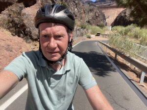 |
| Heading into the island interior on the GC-504 to Ayaguares. Getting out of Maspalomas requires careful navigation on busy roads. But once you’re past the motorway, it’s nice and quiet | At the start of the steep bit at the head of the valley. Which we attempted in full sun at high noon, of course. Which is probably why I look so grim |
 |
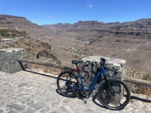 |
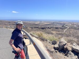
| Val digging deep to get to the top of the 490m / 1600ft climb | Trusty steeds at the top. They were built out of solid cast iron bars, I think, but were pretty indestructible |
 |
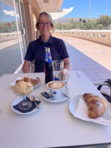 |
| Admiring the view on the way back down near Montana la Data. If you look carefully you might just be able to see the lighthouse, sticking up down on the coast | The “Labrador” restaurant had shut down unfortunately, but we got some pretty decent coffees and ice cream close to the of our ride in Mediterraneo Café in Sonnenland instead. |
 |
|
| At the top! Hooray! And yes – I know – I look like I am about to explode (I didn’t feel too bad actually) | |
Interactive map
(Elevations corrected at GPS Visualizer: Assign DEM elevation data to coordinates )
Max elevation: 488 m
Min elevation: 1 m
Total climbing: 716 m
Total descent: -716 m
Total time: 04:32:32
You can read earlier and later days’ blogs below
Previous day’s blog
Next day’s blog
Ireland home page
 Save as PDF