Ireland day 1295. Tuesday 15 April 2025- Balbriggan Laytown
| Today’s summary | Decided to try to walk from Balbriggan to Laytown on the coast. Never done it before and with a high tide scheduled in the middle of the day, I wasn’t sure we would be able to get through . Undeterred we caught the train to Balbriggan and managed to hike all the way despite the tide. The path almost vanished in a couple of places and it was a bit of a fight to get through, but we made it. Train back at the end. Video calls to friends on the UK south coast and in France in the evening. More noodles to eat and Netflix to watch, to finish off the day | ||||
| Today’s weather | Overcast but dry. Moderate (cold) northerly wind. Appx 11c | ||||
 |
 |
||||
| Today’s overview location (The blue mark shows the location of our route) |
Close-up location (The blue line shows where we walked) (Click button below to download GPX of today’s walk as recorded, or see interactive map at bottom with elevations corrected): Balbriggan to Laytown coast walk |
||||
Commentary
We have walked most of the readily accessible routes near Malahide but I’m always on the lookout for potential new paths to explore. So this morning found me poring over my “Strava” heat-map looking for possibilities. (The heat-map is a great innovation, by the way, as it shows you actual places that people have really walked, as opposed to just showing paths that may or not be accessible). As I was glancing up and down the coast between Malahide and Drogheda on the map, I noticed that there was a thin blue line linking the more southerly town of Balbriggan to the more northerly settlement of Laytown (of beach races fame). This meant that there could be a coastal route – that somebody had actually walked – linking the two.
I thought hiking it would be worth a try, especially as I now have my senior railpass, which means that both Val and I can travel (together) for free. The two ends of the route are conveniently at rail stations which are directly accessible from Malahide, so getting there and back couldn’t be easier. The big drawback I could see was that the blue line followed the shoreline, which I knew could be problematic – or even submerged – at high tide. And of course as luck would have it, a high tide was predicted to occur exactly when we would be walking the narrowest stretches (and a Spring tide, at that).
Anyhow, we needn’t have worried. The beach made for easy walking for much of the way – even at high water – and there turned out to be a thin path through the coastal dunes which avoided the narrowest and rockiest sections of beach. It was a bit of a fight through the brambles at a couple of spots , and we had to make an inland detour to cross the Delvin river at Gormanston. But other than that, it was pretty straightforward and with almost nobody at all about. In the remoter sections, you could almost imagine you were a castaway on a desert island.
We found a handily-placed bathing shelter just before the military rifle range where we paused to have lunch, out of the cold wind. Then we finished off the walk, arriving at Laytown station after about three and a half hours on the beach, and with only nine minutes to wait for a diesel to take us straight back to Malahide.
Once back in the flat, I went straight into a video call with a friend in Dorset, UK, and Val dropped round to SuperValu for some milk. After cups of tea, more noodles for dinner and a video call to some friends in France, we rounded off the evening with a couple of enjoyable episodes of “Mad Men” on Netflix.
So altogether an excellent day, with a real sense of achievement at exploring somewhere completely new.
Today’s photos (click to enlarge)
 |
 |
| Good distant view of the Cooleys from Balbriggan station. Slieve Foye is in the centre | Balbriggan Martello tower. One of the relatively few still remaining that hasn’t been converted into a house |
 |
 |
| This curious outcrop of turf on the beach looks strangely un-natural! | I knew I shouldn’t have put my shorts on! The wind was freezing |
 |
 |
| A delicate balancing act | Heading north into the wind and looking pretty bleak and deserted near Gormanston |
 |
|
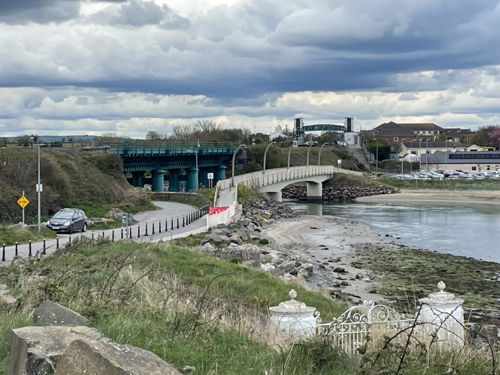
| Approaching Laytown from the south, with the station bridge on the skyline | |
Interactive map
(Elevations corrected at GPS Visualizer: Assign DEM elevation data to coordinates )
Max elevation: 13 m
Min elevation: 0 m
Total climbing: 153 m
Total descent: -156 m
Total time: 03:32:19
You can read earlier and later days’ blogs below
Previous day’s blog
Next day’s blog
Ireland home page
 Save as PDF