Ireland day 1292. Saturday 12 April 2025- Slieve Foye Leading 2
| Today’s summary | Drove up to Carlingford to lead a Club walk round Slieve Foye. Val went into Dublin for a lecture at Farmleigh on Lafcadio Hearn – an Irish-Japanese foreign correspondent of the late 1800s. The walk was enjoyable today despite there only being three of us. Weather was good for once and we had excellent views especially at first. Refreshments in the Anchor Bar at the end. Potato parathas and poached eggs for dinner | ||||
| Today’s weather | Hazy sunshine and mostly dry all day, though a few drops of rain in the late afternoon. Light north westerly wind. Appx 12c | ||||
 |
 |
||||
| Today’s overview location (The red mark shows the location of our route) |
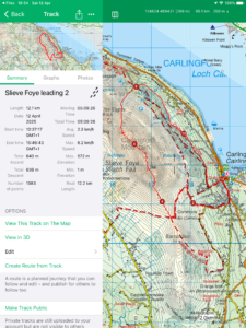
Close-up location (The red line shows where we walked) (Click button below to download GPX of today’s walk as recorded, or see interactive map at bottom with elevations corrected): Slieve Foye leading 2 |
||||
Commentary
Well the weather forecast for today wasn’t great but in the end we were OK and broke the Curse of the Cooleys. We stayed mostly dry for the Club walk which I led up and around Slieve Foye from Carlingford today. Hooray!
I had an early start from the flat in order to be parked up at the start point well beforethe scheduled departure time of 10:30am. Val couldn’t join me sadly, as she had a clashing engagement. She had booked to go to a lecture at Farmleigh by Bill Emmott (a former editor at the “Economist”) about Lafcadio Hearn, an Irish-Japanese foreign correspondent from the late 1800s. She came away impressed, I think.
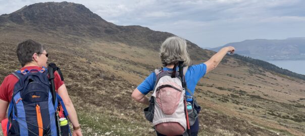
There were only three of us on the walk today, sadly, as many of the others were either otherwise occupied, or nursing various injuries. Hopefully we will be back to full(-er) strength shortly. It’s a shame that more couldn’t make it, as it was a really good walk today. The weather wasn’t too cold, too wet or too windy. Almost perfect for a good leg-stretch in the hills. The views at the start were excellent, though it began to haze over later and we even had a few spots of rain on the last stretch to Carlingford.
There were lots of people out and about on the slopes today, but everyone seemed to be in a good humour (and they had left their dogs at home) so it actually felt quite comradely.
From the top of Slieve Foye (which we actually dodged to miss the crowds) we went on to the cairn on the nearby subsidiary summit where we found a sheltered spot for lunch. Then we pressed on north, along the ridge, and descended via the Two Mile River – exactly the same route as I recce’d last weekend. The forestry was still looking devastated after the winter storms, and no less shocking on second viewing than it was the first time.
We returned speedily along the “new” lower path parallel to the forestry road, then when we eventually made it to Carlingford, we treated ourselves to refreshments in the Anchor Bar (sadly non-alcoholic for the drivers) before driving back home.
Once in the flat, Val had returned just before me so we had reheated potato parathas with poached egg for dinner (delicious) and finished off with some TV. I think in the end, a good day was had by all.
Today’s photos (click to enlarge)
 |
 |
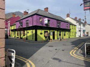
| In central Carlingford today. A bit quieter than it was last weekend (though I was half an hour earlier than last Sunday), and the weather forecast was poor | Twins (non identical, I’m guessing!). At least I assume they were siblings as the both rushed up to the same mummy sheep for safety as soon as we appeared on the scene |
 |
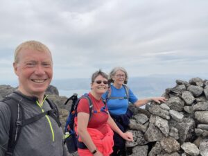 |
| On the final pull up to the summit of Slieve Foye, pausing to look back south over our shoulders to Barnavave | On the subsidiary summit of Slieve Foye. We moved on swiftly from the main top (with the trig point) as it was mobbed with walkers today |
 |
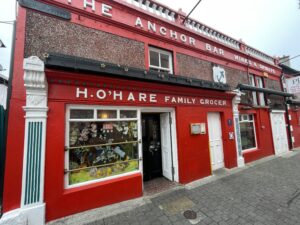 |
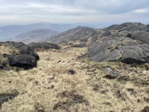
| Looking North along the ridge towards Armagh. I love how bleak and remote it seems | Essential (non alcoholic for the drivers 🙁 ) refreshment stop in Carlingford at the end |
 |
|
| King John’s Castle. I think it might have been partially restored in time for Joe Biden’s visit two years ago. But as far as I know the public still can’t go inside | |
Interactive map
(Elevations corrected at GPS Visualizer: Assign DEM elevation data to coordinates )
Max elevation: 579 m
Min elevation: 3 m
Total climbing: 703 m
Total descent: -703 m
Total time: 05:09:19
You can read earlier and later days’ blogs below
Previous day’s blog
Next day’s blog
Ireland home page
 Save as PDF