Ireland day 1193. Friday 03 January 2025- Back To Usual
| Today’s summary | Another beautiful cold clear day so after a phone call first thing to deal with some admin, Val and I took a slow walk round the Demesne at around lunchtime. After lamb casserole lunch, Val set off to Wonderlights again and I went on an evening stroll round Seapark. Val was back about 10pm and in the meantime I watched a travel blog on YouTube. | ||||
| Today’s weather | Cold clear calm sunny and dry. Light westerly wind. Appx 4c | ||||
 |
 |
||||
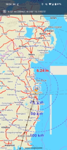
| Today’s overview location (The blue mark shows the location of our route) |
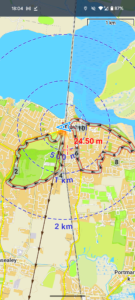
Close-up location (The grey line shows where we walked) (Click button below to download GPX of today’s walk as recorded, or see interactive map at bottom with elevations corrected): Combining Demsne and Seapark loops |
||||
Commentary
Ireland seems to be enjoying a spell of settled sunny weather at the moment, and although it’s quite cold, it is very nice to see the sun. And I think the days are discernibly brighter and longer now, which is always a positive as far as I’m concerned.
In order to make best use of the weather, Val and I got up relatively early then after a long-ish phone call to deal with some admin matters, got ready to go out.
As Val was working at Wonderlights again this evening, we didn’t have all that long, but just long enough for an easy ramble round the Demesne. We’ve both done quite a lot of fairly intense (for us) distance and pace training, so an easier day today felt very much called for.
Once back, we fired up the biological central heating with lunch of some more of the lamb casserole that I made right back in November. It’s been an invaluable standby source of tasty nutrition over the last few months, although it’s nearly all gone now.
After lunch, Val rode off to work on Brompton, and I decided to check out a few more features of the Locus app on a walk round some of the hitherto unexplored (by me) backwaters of the Seapark estate.
I tried out the “My Live Location”, which seems to work quite well though it’s not PIN protected and the tracking link expires after a maximum of 24 hours. Both a bit annoying. I also looked at using “Live Tracking” which is another function which seems to do something similar. But it’s so impossibly complicated to use, I just gave up. Then, once I got back, I used the Locus “Merge Tracks” function to join GPXs from the morning’s and the evening’s walks into a single file. That worked brilliantly.
I spent the rest of the evening relatively quietly with just a light supper – after the lamb infusion I didn’t need much else. Then I treated myself to a travel vlog on YouTube, which filled the gap until Val got back, frozen stiff, at about 10pm.
Today’s photos (click to enlarge)
 |
 |
| Setting off on a bright and cheery morning | Frosty paths everywhere. Care needed! |
 |
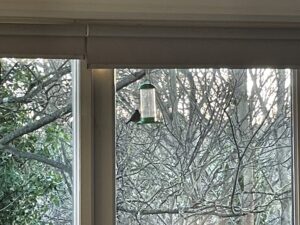 |
| Val spotted this bat box up in the trees in some of the demesne woodland – I wonder who’s at home at the moment | Our friendly neighbourhood robin is obviously feeling a bit bolder than usual. Normally he just picks up the crumbs that have fallen from the bird feeder onto the deck of the balcony. But today, perhaps as there were no intimidating bluetits about to challenge his perch, he decided to venture up and and take a look at the main deal |
 |
 |
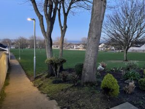
| In one of the “hidden” parks in Seapark. I don’t think I’ve ever seen this one before – and I don’t think it actually even has a name | Crescent moon and Venus above, rising over the new Seamount estate |
 |
|
| View from our balcony first thing this morning. A chilly day beckons! | |
Interactive map
(Elevations corrected at GPS Visualizer: Assign DEM elevation data to coordinates )
Max elevation: 54 m
Min elevation: 1 m
Total climbing: 167 m
Total descent: -165 m
Total time: 05:23:24
You can read earlier and later days’ blogs below
Previous day’s blog
Next day’s blog
Ireland home page
 Save as PDF