Ireland day 0362. Sunday 25 September 2022- Ballylug
| Today’s summary | An enjoyable hike with the Walking Club round the Ballylug woodlands on the north side of the Avonmore river. Lots of laughs (and scones) as ever. Shared a lift from a friend in Portmarnock | ||||
| Today’s weather | Dry and mostly overcast with occasional brief glimpses of the sun. Light drizzle in the evening. Westerly wind. About 15C | ||||
 |
 |
||||
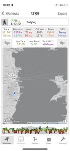
| Today’s overview location (The blue mark shows the location of our route) |
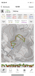
Close-up location (The green line shows where we walked) (Click button below to download GPX of today’s walk as recorded, or see interactive map at bottom with elevations corrected): Ballylug DWC walk |
||||
Commentary
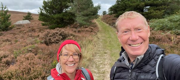
It’s always nice to explore somewhere new, and especially when it’s a bit off the beaten path. Today fitted the bill perfectly, as our Walking Club outing was relatively close at hand, novel, quiet and perhaps most importantly offered excellent access to cafés for refreshment.
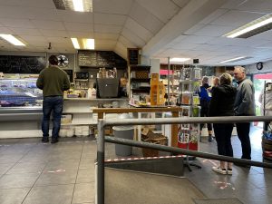
The walk was billed as starting from Laragh at the relatively relaxed time of 11:30. But even though it’s only about 45 minutes’ drive from Malahide, we were sharing a lift from a friend in Portmarnock and we decided to leave early, so we would have plenty of time to enjoy a coffee and scone (obviously) before the walked officially kicked off. So we pitched up at the Glendalough Green café not long after 10:30 which meant that we could take our time over the refreshments and enjoy the homely atmosphere of the café.
Once the rest of the walkers were assembled, we drove a little way further down the valley down a side road through the Clara Vale, which is on the north side of the River Avonmore. There’s a small forestry road leading off to the left after 2 or 3 km / mi and in the clearing at the bottom, we parked the cars and headed off up into Ballylug woods. There were a few walkers and a couple of mountain bikers out today, but otherwise the hillsides were pretty quiet and all the more enjoyable for that. Certainly infinitely quieter than the much busier Glendalough hills on the other side of the valley.
It was a very straightforward walk today, following paths that were clear once you knew where you were going – but which, if I hadn’t been on a Club walk, I would never have known even existed. That’s one of the huge advantages of joining a club in a foreign country – you can cut out a lot of the trial and error in finding out where you can and can’t actually go.
There were almost 20 of us on the walk today, which obviously meant there was much chatting and catching up to be done. So there was barely time to notice the magnificent views that opened up as we skirted round the flanks of Trooperstown Hill and up onto Round Hill (which is today more popularly known as “Boot Hill” – as the photos below explain). A bit like the western foothills of Lugnaquilla, once you get up a bit higher, this side of the valley is mostly open moorland, covered in heather and with expansive views over rolling hills in all directions, and even to the sea out near Wicklow. It reminded me a lot of the Scottish Highlands above Strathdon.
After a stop for lunch which was necessarily quite brief – after all we had only just finished our scones – we headed back down the Rocky Road drovers’ track towards the Clara Vale. We paused to have a look at the impressive and strikingly isolated Bread and Butter rock on the way (you can read more about it in the photo captions below). The heathers along the way were just past their best and beginning to look a bit autumnal, but still impressive nonetheless.
We were soon back at the cars – it was a relatively short walk but seemed to pack in lots of interest along the way, and we both thoroughly enjoyed every aspect of it. And best of all, there was still time to call into Lynhams pub in Laragh on the way back – a visit that was made all the more enjoyable by the fact that I wasn’t driving today.
Well that’s it. An interest filled day out and along a route that I’d definitely like to go back and explore a bit more one day. Now it’s time for a yellow sticker microwave curry that I managed to pick up from Tesco last week. Well we certainly know how to live here in Malahide.
Today’s photos (click to enlarge)
 |
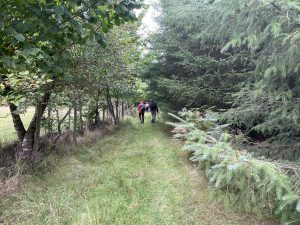 |
| We started as every good walk should – with a cup of coffee and a scone. Today, in the Glendalough Green cafe in Laragh. It’s pretty rustic but serves excellent refreshments and is popular with bikers and cyclists. I think it’s excellent | Heading up through the Ballylug woods onto the slopes of Trooperstown Hill (aka Maoilin or Mweeleen). There are some pretty ancient and magnificent Norway Spruce trees lining the route |
 |
 |
| The summit of Round Hill, which lies to the east of Trooperstown Hill, and which is now more commonly known as Boot Hill. You can see the eponymous boots just below the cairn – they have been cemented there to prevent their removal and have been in position at least two decades. I haven’t been able to get to the bottom of the story of the boots – apparently it’s a memorial to a local hiker, but that’s all I know. | A sudden splash of sunlight on the opposite side of the valley was like turning the emerald green dial up to max |
 |
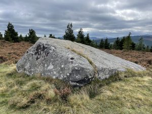 |
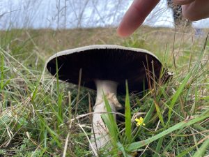
| We came across this impressive large toadstool on the way back down the path. It looked deliciously edible but not one single insect had landed on it and there wasn’t any sign of animal nibblage made me suspect that actually it might not be exactly as it seemed. | There’s an old drove road – the Rocky Road – leading from Clara Vale (which is I think the valley that the Avonmore river runs through) to Dublin and we walked along it for part of our return route. This boulder – which some say is a glacial erratic but which I think is too big – lies alongside the way and is known as the Bread and Butter rock. It’s about 2m/6ft high at its tallest point and was a resting point for the drovers on their way north. They were said to eat their sandwiches here – hence the name. You can see the drove road in the background to the banner image at the top of the blog |
 |
|
| Informal lunch break just below the top of Boot Hill. I consider it still to be official shorts wearing season though nobody else seemed to agree with me as I was the only one today. As far as I am concerned, we have at least another six weeks to go before the leg prisons have to go back on again. | |
Interactive map
(Elevations corrected at GPS Visualizer: Assign DEM elevation data to coordinates )
Max elevation: 396 m
Min elevation: 193 m
Total climbing: 288 m
Total descent: -287 m
Total time: 04:10:12
You can read earlier and later days’ blogs below
Previous day’s blog
Next day’s blog
Ireland home page
 Save as PDF