Ireland day 0347. Saturday 10 September 2022- IceAge
| Today’s summary | Joined an Irish Geological Association bus tour of Wicklow to explore the various ice-age features on display in the mountains. An absolutely fascinating day out. | ||||
| Today’s weather | Dry with sunny intervals. Light easterly wind. About 16C | ||||
 |
 |
||||
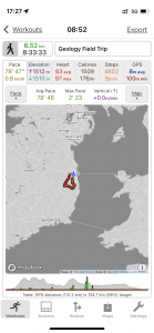
| Today’s overview location (The blue mark shows the location of our route) |
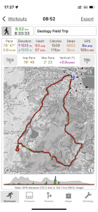
Close-up location (The red line shows where we drove) (Click button below to download GPX of today’s walk as recorded, or see interactive map at bottom with elevations corrected): Wicklow Ice Age field trip IGA |
||||
Commentary
When you think of Ireland you don’t normally think of an island completely blanketed under a cap of ice two thousand metres / 6000ft thick. Yet this has been its natural state for some 85% of the last three million years of its history. It’s only recently – in geological terms – that the island as we know it today emerged from its glacial cloak.
The reason I know these things is because today I went on a Geology Field Trip. The particular field trip in question was organised by the Irish Geological Association (IGA) and was entitled “The IGA Legendary Bus Tour of Wicklow with Pete Coxon”. The IGA is an association open to anyone with an interest in geology – you don’t have to be a professional geologist. I joined because I like understanding how the world around me came to be the way it is, and because the Association lays on some interesting lectures that I’d like to attend. But today’s trip sounded particularly fascinating. And with a title like that how could you not want to go?
Personally I think the history of the ice ages is especially fascinating for two reasons. First, because the topography of the land is more or less as it is today – the ice ages are too recent for plate tectonics to have had time to rearrange things significantly. And second, the plants and animals that inhabited the planet around that time are mainly still recognisable in the modern world. So it’s easier to understand what what’s going on in this relatively recent geological period than it is to try and envisage things hundreds of millions of years ago.
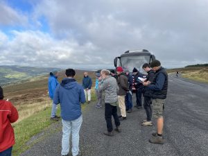
Today’s coach trip round Wicklow met at the ungodly hour of 8:30am in Nassau Street, central Dublin. So an exceptionally early start from Malahide was called for. It was excellently led by Pete Coxon, a recently-retired Professor of quaternary palaeogeography at Trinity College.
So what did I learn today? Well so much actually that it’s hard to know where to start. Perhaps the most interesting thing is that the earth has been cooling slowly for several tens of millions of years. I’m not sure if there’s a definitive reason why – possibly due to gradual CO2 sequestration, possibly due to the Panama isthmus closing and affecting ocean circulation, maybe even due to changes in solar output. Until 30 million years ago there was no permanent ice on earth and it was only at that time that the ice cap on Antarctica started to form. But it was only 3.6 million years ago (less than one tenth of one percent of the age of the earth) that things took a dramatic turn for the worse.
At that point in the cooling trend, tiny (1 or 2%) reductions in the amount of solar energy reaching the earth at critical points of the year, caused by the three “Milankovitch” cycles in the earth’s orbit, became significant enough to trigger the growth of mountain and north polar ice caps. As these ice caps grew, the earth’s albedo (reflectivity) increased so the cooling effect intensified. The earth has been plunged into a series of ice ages ever since then, with a cyclical advance and retreat of the ice roughly in synchrony with the Milankovitch cycles. The periodicity was initially roughly 40,000 years but it later increased to 100,000 and there have been at least 40 “ice ages” since the process started 3.6 million years ago. Each one has tended to be colder than the previous one and on the current trend, the next ice age should have started in about 3000 years time – and probably been the coldest yet. But current CO2 levels are so high now, as a result of human activity, that this ice age won’t happen and is unlikely to recur until CO2 levels drop dramatically – and possibly maybe never.
By the way, don’t make the mistake – as I did – that the ice cap covering Ireland and northwestern Europe was continuous all the way to the North Pole. It wasn’t. There was probably a body of water surrounding the pole, to the north of Europe and Scandinavia, which remained ice free in the summer. The Arctic Ocean, in fact, just a bit smaller than now, sandwiched between the polar ice cap and the continental ice caps to the south.
And also, don’t assume that because Northern Europe and North America were glaciated in the ice age, that Siberia would be too, because large parts of it weren’t either. The air was too dry for snow to fall there, so it remained ice free – and in fact inhabited by humans and megafauna like mammoths. Though survival must have been hard as it would be unimaginably cold in the winter. During an ice age, the Bering Sea between Siberia and Alaska would also be dry land and non glaciated. So it formed a land bridge allowing the first humans to access the New World.
These is also some speculation that small areas of the Southern Hemisphere may actually have been slightly warmer during an ice age than they are today.
Today’s field trip focused on the most recent Ice Age, as the evidence of what happened is the most fresh. As far as I can tell, most of the interesting stuff about ice ages happens at the starts and ends. This is when the ice caps are forming or decaying – for most of the 100,000 years that a typical ice age lasts, the ice cap just sits there and smothers everything in a slow moving blanket.
The end of the last ice age is particularly interesting because it seemed to happen quite quickly about 20,000 years ago. It’s not clear what the cause of the end was – perhaps the ice caps were so big they were unstable and collapsed on themselves. Perhaps the Milankovitch cycles delivered sufficient extra sunlight to trigger a massive melt. Perhaps slight warming reduced the solubility of CO2 in the sea, causing a warming feedback loop. Anyway the upshot was that sea levels rose dramatically from their ice age levels 120 metres below modern levels.
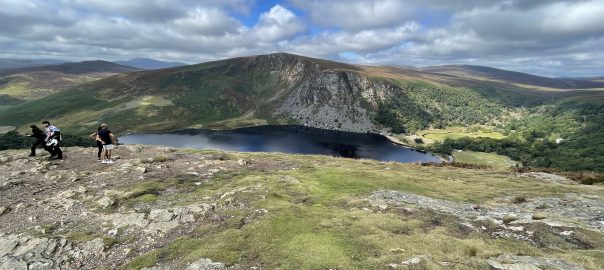
You can see plenty of evidence of the ice age in Wicklow – but only if you know where to look. The green hillsides round Glenasmole, the glacial corries at Upper Lough Bray, the flat plateaux around Sally Gap, the submerged moraines in Lough Lahanagan and the gigantic glacial Lake Blessington. You can see some of them in the photos below.
The last ice did have one final sting in its tail – the Younger Dryas. This was a cold “snap” starting about 13000 years ago and lasting 1000 years – in other words seven thousand years after the “main” ice age had ended and the main glaciers had gone. It started and ended very quickly with changes in annual average temperatures of 15 to 20 C in the space of perhaps as little as a decade. In this period, glaciers reappeared on the hills of Ireland – although there was no blanket ice cap as there would be in a “proper” ice age. In fact many of the more obvious glacial features in a Wicklow actually derive from the Younger Dryas rather the main ice age itself. (Before you ask – the cause of the rapid cooling and warming at either end of the Younger Dryas isn’t totally clear but it’s probably due to changes in the salinity of the North Atlantic Ocean disrupting the “North Atlantic Conveyer” which brings warm water from equatorial regions to the north. A comet impact has also been implicated but the evidence is sketchy).
One final thing I did learn today is that there is some evidence that the Greenland ice sheet melted completely in some of the earlier interglacials. If that happens in the current interglacial – as man-made CO2 emissions seem almost certain to guarantee, global sea levels will rise 12 metres / 40ft. Quite a prospect, given how many major cities are on the coast.
Phew that was a lot to digest. But if you’d like to lean more I’d suggest getting hold of a copy of Pete Moxon’s book “Wicklow in the grip of an Ice Age”. In the meantime, I’m going to spend a few moments making doubly sure that our flat is at least 12 metres above current sea level. I don’t want to wake up with wet feet.
Today’s photos (click to enlarge)
 |
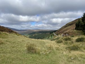 |
| There were twenty of us in the bus – which struggled to negotiate some of the roads to the more interesting geological features. It was nice not to be driving. | Looking up towards the Sally Gap – the highest public road in Ireland. The upper mountainous areas are relatively smooth – because they just sat underneath a relatively static ice sheet and weren’t scoured like the lower slopes. At the higher altitude, the ice was colder so it froze harder and stuck to the bedrock like glue. It moved over the bedrock in a sort of plastic flow, which didn’t have such an abrasive effect |
 |
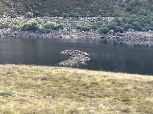 |
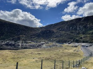
| The private road down to Lough Nahanagan. Today, the lough is the lower of two bodies of water, connected via a pumped water hydroelectric scheme (the upper lough is completely manmade and sits atop nearby Turlough Hill (at the right of the photo) – Turlough is the Irish word for a body of water that dries up from time to time). It’s geologically interesting because a number of glacial features were revealed when the lough was partially drained during the construction of the hydro scheme. | One of the features that’s now visible is the previously-submerged terminal moraine of a small glacier which appeared in this corrie during the Younger Dryas mini Ice-Age which clamped down on the planet for about a thousand years, some seven thousand years after the main ice age had ended |
 |
 |
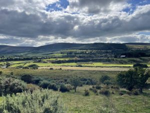
| If you look across the valley from this point above Hollywood and squint your eyes a bit, you can see some horizontal flat planes on the fields on the valley-side. These represent the shoreline of the glacial Lake Blessington, and are about 60m / 200ft above the present day valley floor. So this temporary meltwater lake was pretty massive. (By the way a smaller version of the glacial lake was recreated in 1940 with the construction of a dam in the Liffey to the south of Blessington, giving rise to the Poulaphouca Reservoir. To create the lake, a relatively small dam across one of the outlet channels carved by the efflux from Glacial Lake Blessington was all that was needed) |
This is the only view I could get – through the bus windscreen as we drove along – of the narrow Hollywood Glen. Even though it seems charming but unremarkable today it is actually quite an astonishing place. Because it’s where water flooded out from the temporary Lake Blessington, which filled with meltwater as the glaciers were retreating. It was dammed by the remains of the main ice cap to the west – where cliffs of ice 2000 metres / 6000 ft high both fed the lake with their meltwater, and prevented it from escaping through their damming effect. Eventually the water found a way out under the edge of the ice cap and carved out these outlet channels in solid bedrock under the ice. So 18,000 years ago, the Hollywood glen was a roaring cataract covered with a ceiling of solid ice, and the remarkable thing is that for a short distance at the start of the glen, the water actually flowed uphill, forced out by the head of water in the lake behind it. |
 |
|
| Overlooking the Bohernabreena reservoir in the Glenasmole valley. The valleysides are green because calcareous soil – which neutralised the underlying acid granite – was pushed up the valley (from right to left in the picture) by the southerly advancing northern ice sheet. It collided with the northerly advancing glaciers coming down from the Wicklow mountains somewhere in upper Glensamole. | |
Interactive map
(Elevations corrected at GPS Visualizer: Assign DEM elevation data to coordinates )
Max elevation: 524 m
Min elevation: 1 m
Total climbing: 1980 m
Total descent: -1969 m
Total time: 08:33:30
You can read earlier and later days’ blogs below
Previous day’s blog
Next day’s blog
Ireland home page
 Save as PDF