Ireland day 0321. Monday 15 August 2022- DonardRecce
| Today’s summary | Headed north of the border again to recce the Slieve Donard walk for next weekend. Started at Newcastle and did a simple up-and-back route via the Glen River. Very enjoyable though a bit wet | ||||
| Today’s weather | Cooler than recently, and quite wet but with very little wind. About 18C | ||||
 |
 |
||||
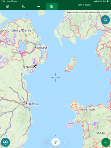
| Today’s overview location (The blue mark shows the location of our route) |
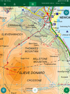
Close-up location (The green line shows where we walked) (Click button below to download GPX of today’s walk as recorded, or see interactive map at bottom with elevations corrected): Donard Recce |
||||
Commentary
I’m going to keep this blog short as it’s getting late now and I’ve already had a couple of glasses of wine so don’t feel inclined to pen an opus. Besides, I was up exploring the same area as today as recently as 27 May. So if you really want to learn more about the area, just check back to the earlier blog.
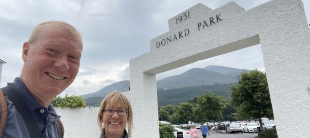
Anyway – what’s the story about today? Well, in a nutshell, I’m leading a walk for the Dublin Walkers up Slieve Donard – the highest peak in Northern Ireland – next weekend. So, making the most of a day off work, Val and I headed up over the border today to do a quick recce.
You don’t normally notice much when you cross from the Republic to the North, other than the abandonment of metric measures on the road signs. But today we did notice one big thing when we crossed the border – it almost immediately started to rain. After weeks of dry warm sunny weather, in many ways the advent of rain came as something of a refreshing relief. I just rather wished that the weather hadn’t chosen today to start precipitating – with a long ascent to a relatively high mountain in prospect, a soaking en route was definitely something we could have done without.
We eventually pitched up at the start point in Newcastle but not without stopping off first at the Carrickdale Hotel for a quick coffee en route. Very nice though not cheap. Then Newcastle itself was a bit disrupted by roadworks, so it took us a bit of complicated navigation actually to find the car park. But eventually we were there just after noon, and ready to set out up Slieve Donard, and all set to check out our prospective route up the Glen River.
As it happened, it was briefly dry when we set out, so actually quite a pleasant start to the day. But as soon as we cleared the trees after about 2km / 1 mile, the heavens opened and we started to get properly wet. Waterproof jackets were donned though as it wasn’t too cold – and there was no wind – we refrained from the sweatbox over-trousers. Although that was possibly a mistake in my case at least as I was wearing cotton shorts – and they were absolutely saturated by the time we got back. And cotton being cotton, it takes ages to dry out properly.
The ascent was completely straightforward apart from the rain. There were a few people about despite the weather – though when we got to the top there was nobody there, unlike last time when it had been quite busy. Back in May, the last time I visited, I’d headed off the summit north to meet the Brandy Pad to create a loop walk back to the bealach between Slieve Donard and Slieve Commedagh. But this time, in view of the fact that we had made a later start and it was getting late, and in view of the rain, we decided to abandon the loop bit and just return back down the way we had come up.
The return was as straightforward as the ascent, although it’s quite a stony path so it’s hard on the feet and you have to watch your step – especially when the stones were slippery, as was the case today.
We were back at the car park just before six pm – time to reflect on an excellent day out and a route that I’m looking forward to leading. We didn’t stop on the drive back – tempting as a coffee would have been – and it still took us the best part of two hours to get back to Malahide. Mainly because there’s no speedy route east from the main Dublin-Belfast road, out to the coast at Newcastle. I’ve tried a few different alternatives but they are all pretty slow and winding.
Well that’s more than enough for now. And this was only supposed to be a short blog! So the perfect time to call a halt and sign off. Back tomorrow!
Today’s photos (click to enlarge)
 |
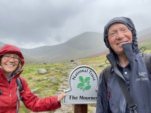 |
| Heading up the Glen River from Newcastle. We were on the look out for bilberries / fraughans which judging by the purple bird poo should have been abundant in the area. But we didn’t manage to locate them. And anyway the birds may have completed the harvest ahead of us. | Strange to see the National Trust (rather than the OPW) but I had to keep reminding myself that we were in a different country today |
 |
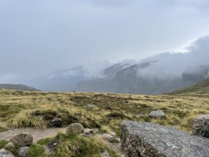 |
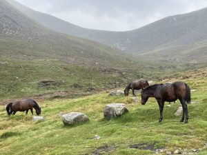
| There were half a dozen semi-wild ponies grazing on the fells in the upper Glen River valley. Looking a bit bedraggled today | Looking over the Mourne Wall into the Annalong River valley at the col / bealach between Slieve Donard and Slieve Commedagh |
 |
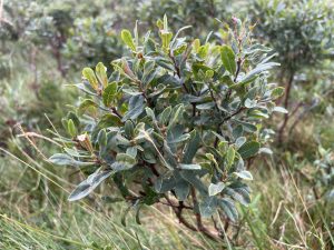 |
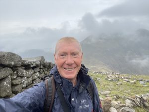
| Heading up the last drag to the summit (853m / 2790 ft) of Slieve Donard. Looking a bit worse for wear in the rain. Although it did dry up briefly a bit later on | Abundant bog myrtle (Myrica gale or Roideóg in Irish) – with its wonderful eucalyptus scent in the upper Glen River valley |
 |
|
| On the top. I’m really not happy about that double chin. I’ll have another glass of wine and then think what to do about it. | |
Interactive map
(Elevations corrected at GPS Visualizer: Assign DEM elevation data to coordinates )
Max elevation: 847 m
Min elevation: 5 m
Total climbing: 885 m
Total descent: -885 m
Total time: 05:22:08
You can read earlier and later days’ blogs below
Previous day’s blog
Next day’s blog
Ireland home page
 Save as PDF