Ireland day 0288. Wednesday 13 July 2022- IrelandsEye
| Today’s summary | Caught up on admin in the morning while Val was at work then after lunch (Val had a half day) we went down to Howth via bus and DART and got a ferry over to Ireland’s Eye. Spent the afternoon exploring this “hidden gem” island in the Irish Sea. Fabulous | ||||
| Today’s weather | Warm and dry with a moderate westerly breeze. Occasional sunny intervals, otherwise light cloud. About 20C | ||||
 |
 |
||||
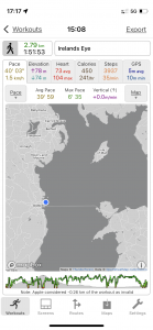
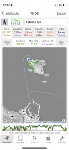
| Today’s overview location (The blue mark shows the location of our route) |
Close-up location (The green line shows where we walked) (Click button below to download GPX of today’s walk as recorded, or see interactive map at bottom with elevations corrected): Irelands Eye summit and beach |
||||
Commentary
I think islands – and especially uninhabited ones – exert a certain sort of magic over everyone. They definitely do over Val and me and one in particular had done so for several months.
Last October, soon after we had arrived in Malahide, we spent an afternoon looking round the village of Howth – it’s a charming, and exceedingly prosperous, fishing port just down the coast from here, situated on the tip of the eponymous Howth peninsula. We’ve visited several times but last October particularly sticks in my mind because as we were walking on the harbour, we came across a placard “Boat trips to Ireland’s Eye departing now”. We talked to one of the boatmen in charge of the vessel and he told us that this was going to be the last trip of the day – and indeed of the season – so if we wanted to go before 2022, we better jump on board. We nearly did, but at the last minute we decided against it because we learned that the boat wouldn’t actually be landing on Ireland’s Eye, only circumnavigating it. So we said no, and put it on the to-do list for 2022.
But what, you might ask, actually is Ireland’s Eye? Well it’s a small uninhabited island just offshore from Howth. There’s nothing on it apart from an old Martello tower (one of the best preserved, in fact) and a ruined chapel. And a very large colony of seabirds which includes guillemots cormorants and puffins. The island is privately owned – by the Tetrarch property investment group – same group that owns the Deer Park hotel and golf club on mainland Howth. Nobody seems to have any idea what they plan to do with the island, but as much of it is protected under various EU directives, I suspect there may be limits to what they can actually do. Let’s hope it stays as unspoiled in the future as it is today.
The island was originally called Inis Ereann , which means “Island of Ireland”. The Vikings translated the Anglicised name to Ireland’s Ey, where “Ey” was the old Norse word for “Island” (similar to the Norwegian “øy” today). And of course it was only a short hop from Ireland’s Ey to Ireland’s Eye, although in this case the “Eye” word has nothing to do with the organ of sight. So that’s how it got its slightly unusual name. Occasionally people emigrating from Ireland speak of there being a “tear in Ireland’s Eye” as it was sometimes the last sight of their homeland before they departed for distant shores.
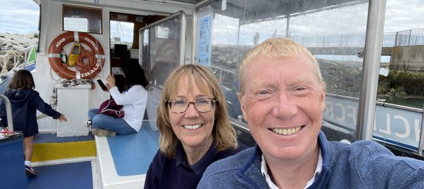
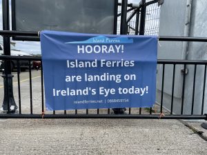
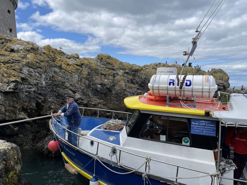
Anyway, now it was high summer 2022, with good weather and a relative lull in the pandemic, so we thought that it was sort of now or never to attempt the journey we had postponed last October. Val had a half day at work today, so once she was back and we had hurried our lunch, we caught the trusty 102 and then the DART and we were in Howth, on the quayside waiting to go, less than an hour and a half after she’d finished work. Luckily, of the two ferry companies visiting Ireland’s Eye, one of them was attempting the landing today. So we bought tickets, jumped aboard the Adam Patricia and sat back to enjoy the voyage.
Actually it took all of 15 minutes to get there but it was very interesting, as you sail round the back of the island to see the cliffs which are completely hidden from sight on the mainland – it’s a bit like going to the dark side of the moon, except that it is teeming with a cacophony of seabirds, in a way that I suspect the moon isn’t. We soon reached the unlikely looking rocky chasm which was actually the landing spot and, along with a handful of other passengers, scrambled onto dry land. The captain said he would be back to collect us “at about half past five” – which sounded slightly alarmingly vague, but gave us a full two hours to explore.
You get a tremendous sense of freedom on the island – there’s no razor wire to keep you out, or urgent signs warning you of impending prosecution. The only constraints on your movement are common sense, the dense undergrowth (bracken, mainly) and the need to keep well away from roosting seabirds (they will certainly ensure you don’t get too close).
We made the most of it, and climbed up to the top of the hill to admire the fantastic views. Up to the Mournes in the north, and right across Dublin Bay to the Wicklow hills in the south. An unusual perspective on familiar surroundings. Strangely, once again, Wales remained completely invisible, despite not being much further away than the Mournes.
After a pause on the top for a brief picnic, we descended straight down to the beach, which was large, sandy, mercifully dog-free, and had almost nobody on it. I was slightly sorry that we had left it until relatively late in the day to visit, as I felt that on a good day like today, it would be easy to spend a whole day there, just relaxing in the sun and soaking in the view.
All too quickly the time passed, so we headed back to the landing cove in good time to catch the ferry. We didn’t particularly want to be marooned there overnight, and I wasn’t entirely sure what “about ” 5:30 would actually mean in terms of when the boat might depart. In the end, he was more or less on time, so we needn’t have worried. The boat soon had us back in Howth and a DART-and-bus reversal of our outbound journey saw us back in the flat by about 7pm.
It was a thoroughly excellent day out – one of the best – made all the more so because it was more or less done on the spur of the moment and it all worked out perfectly. The whole trip reminded me a lot of the family summer holidays we used to have to the Scilly Isles, off south west Cornwall, many years ago. Many happy memories there.
But for now, as Ireland’s Eye is an omnipresent landmark visible all the way up the coast in our part of Eastern Ireland, every time I see it I will remember that a long standing itch from 2021 was finally scratched today, and will be able to say smugly to myself “I’ve been there”.
Today’s photos (click to enlarge)
 |
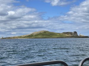 |
| There are two ferry companies serving Ireland’s Eye based down at Howth. But only one of them actually lands on the island and even then only on certain days and at certain times, when the wind and tide are favourable. Luckily, today was one of those days so we were able to join the boat for the short hop over to the island | Ireland’s Eye, as it looks when you’re just leaving Howth harbour. It’s only about a kilometer and a half / a mile offshore and it takes about 15 minutes to get there on the small ferryboat. The island is roughly triangular, about 1¼ km / ¾mi across, and with a peak 69m / 225ft high in the middle. Round the back from where this was taken are impressive sea cliffs that seem to slice the back of the island right off |
 |
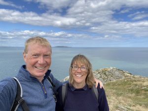 |
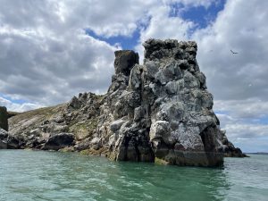
| Some of those sea cliffs. they are covered in guano – you can tell from the colour and the smell – and are the favoured nesting grounds of guillemots, who evidently don’t mind the fishy odour | Here we are on the top of the peak, with Lambay Island (which surely be on the list to visit, though it’s much more difficult) on the horizon behind us. |
 |
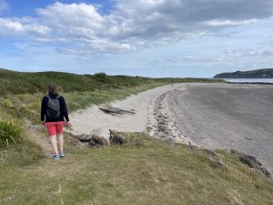 |
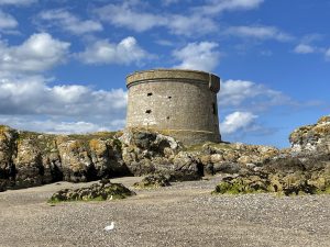
| The Martello Tower, built by the British in 1803 to fend off Napoleon should he ever decide to pay a visit. Fortunately he never did, so the fortifications haven’t ever been put to the test | There’s a beautiful sandy beach spanning the southwest side of the island. I can see how this might actually be a good spot to swim, especially if the tide was a bit higher so all that sand would be underfoot. No lifeguards on duty here though. |
 |
|
| Landing is a pretty haphazard affair. There’s no harbour or anything, just this sheltered rocky inlet with a few rough steps hewn into the rock face for you to scramble up. It was relatively easy when we arrived and the tide was high, but later on when we left and the tide had gone out, it was a slightly more perilous embarkation | |
Interactive map
(Elevations corrected at GPS Visualizer: Assign DEM elevation data to coordinates )
Max elevation: 55 m
Min elevation: 0 m
Total climbing: 86 m
Total descent: -85 m
Total time: 01:51:32
You can read earlier and later days’ blogs below
Previous day’s blog
Next day’s blog
Ireland home page
 Save as PDF