Ireland day 0281. Wednesday 06 July 2022- Achill
| Today’s summary | Finished off the section of the Great Western Greenway from Mulranney to Achill, they followed Achill Cycle Loop 1 round the southern part of the island. Followed the Greenway back to Mulranney in the evening. Longest bike ride I’ve done for many years. Really enjoyed it, despite the strong headwind on the outward ride. | ||||
| Today’s weather | Very heavy low cloud with mist above about 300m / 100ft. No sun. Drizzle in the morning but dry all afternoon. Persistent strong to gale force westerly wind. About 15C | ||||
 |
 |
||||
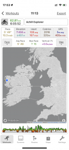
| Today’s overview location (The blue mark shows the location of my route) |
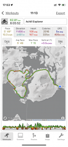
Close-up location (The green line shows where I rode) (Click button below to download GPX of today’s ride as recorded, or see interactive map at bottom with elevations corrected): Achill from Mulranney cycle |
||||
Commentary
In the past, I used to do quite a lot of cycling. But more recently and especially since I had quite a bad accident in 2006, I haven’t done so much – I’ve spent more of my time on long distance walking and trekking. So today’s bike-based exploration of Achill Island, here on the west coast of Ireland, would be my longest ride for many years. I was looking forward to it – both for the joy of getting back on my bike again, and also for the intrinsic interest in visiting somewhere new.
Since it stays light very late here at the moment, I wasn’t in a rush to get started as I knew I would have plenty of time in the evening to get back before dark. And the weather forecast wasn’t too bad – rain wasn’t expected until the evening (and it still hasn’t arrived now – at 9pm). So I had a leisurely morning and then headed over to a nearby café for breakfast. Once I’d eaten and packed up, I was ready to go by 11 (as I have said many times – I’m really not a morning person!).
The first stage in my cycle ride was to finish off the final 15km / 10 mi of the Greenway from Mulranney to Achill sound. It was an enjoyable ride, though as I was cycling more or less due west, I found the strong headwind quite hard going. Eventually, I made it to the bridge over to the island – by that stage I was a bit wet because of the thick misty drizzle on the way, but already starting to dry out in the strong wind.
Achill Island is the largest in the “Irish Isles” and in many ways resembles Lewis, Harris or Skye, off the west coast of Scotland. It’s bleak and windswept, and the air is redolent with peat smoke. It’s also very beautiful, in a raw rugged sort of way – well at least the bit I could see below the obscuring layer of thick cloud which blotted out everything higher than 300m / 1000ft was. There are a number of marked cycle tracks which offer circular routes joining up some of the quieter roads, and visiting some of the main sights of Achill. Ideally, I would have liked to get right out to the north west tip of the island, perhaps as far as Keel, maybe including a visit to the deserted village while I was there.
But I had to be realistic. The strong westerly wind, which by this stage was near gale force, would have made the ride very hard work – even though it would have been great coming back – and probably not very enjoyable. So instead I opted for a slightly shorter loop of the south part of the island – known on the Achill website by the imaginative name of “Achill cycle loop 1”.
It turned out to be a good choice. The ride explores some of the cliffs, shores and hinterland of the island, and gives you a very good idea of just how bleak and windswept it is. Although the abundance of fuchsias did suggest that even though it looks and feels desolate, the climate on the island is probably actually mild. That and the masses of Gunnera plants which seemed to be springing up everywhere. Apparently it’s an unwanted weed – which is definitely the first time I have ever come across an island being threatened by an invasion of giant rhubarb.
The route did have some pretty steep climbs, though, and because my trusty Brompton only has two reliably working gears at the moment, much to my shame I did find myself having to get off and push the bike up some of the steeper ascents. Once I’d found a suitably sheltered spot for lunch – though even there the down jacket and woolly hat did have to come on again while I was eating – my route turned first south then east – and immediately the going became immeasurably easier. In parts I felt almost as if I was on a motorbike, effortlessly watching the scenery fly by. Perhaps now I am beginning to understand what the attraction of those e-bikes is. But it’s a slippery slope and one I am definitely not ready to slide down it just yet.
Once the loop was completed, I had banked on being able to stop at Kates Café near the bridge over the sound back to the mainland – but it was closed when I got there. Luckily I had some coffee left in my flask, as well as come chocolate biscuits, so I paused down by the harbour for a quick break before crossing back to the mainland and reversing my journey along the greenway. I was back at Mulranney at about 5:30pm.
I really did enjoy the ride. At 62km / 40 miles it did indeed turn out to be the longest ride I’ve done in several years. So today’s dinner of fish and chips followed by ice cream over at McLoughlin’s bar felt to be particularly well deserved this evening. Besides, the bar has a great view over the bay, so it was a relaxing spot to enjoy something to eat and watch the day slowly ebb away.
Well, that’s it for now. Tomorrow it’s a leisurely cycle ride back to Westport but as my train to Dublin doesn’t leave till after 6pm, I will have plenty of time to do some exploring around Mulranney, and still have some time left for a good look around Westport too. I’m looking forward to it!
Today’s photos (click to enlarge)
 |
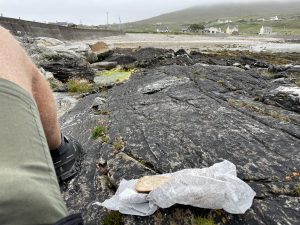 |
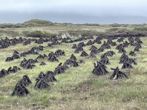
| Turfs (peat) are still cut here for domestic use – the characteristic smell of burning peat fills the air in all the towns and villages you pass through. It’s just like Islay malt | Lunch break at Dumha Éige beach. It was the only sheltered spot I could find to enjoy my bacon sandwich. And there’s nothing worse than sand in your sandwiches |
 |
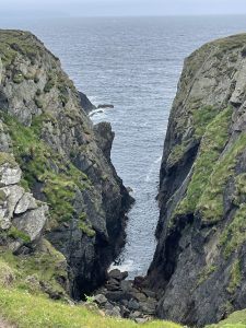 |
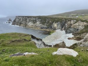
| A bit further round the coast from Dumha Éige is Béal na hAisléime. Some years a sandy beach is here, others not – it all depends on the winter storms. This year, it was all pebbles and boulders, so clearly the wind must have been in the wrong direction | Deep cleft in the coast at Killeennabausty (these names are hard, I’ll admit!). It was a lot more spectacular in “real life” than in the photo |
 |
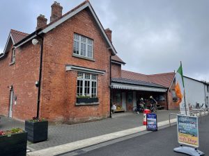 |
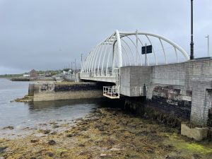
| Looking back to the mainland over the Michael Davitt bridge at Achill sound. The gap between the mainland and the island is small and most of the channel is blocked off by a causeway. The bridge covers the last 50 metres or so. The first bridge was built in 1887 and this is the third one to be on the spot. This one opened in 2008. It’s a swing-bridge | The old station at Mulranney. Today it’s a bike hire shop and cafe |
 |
|
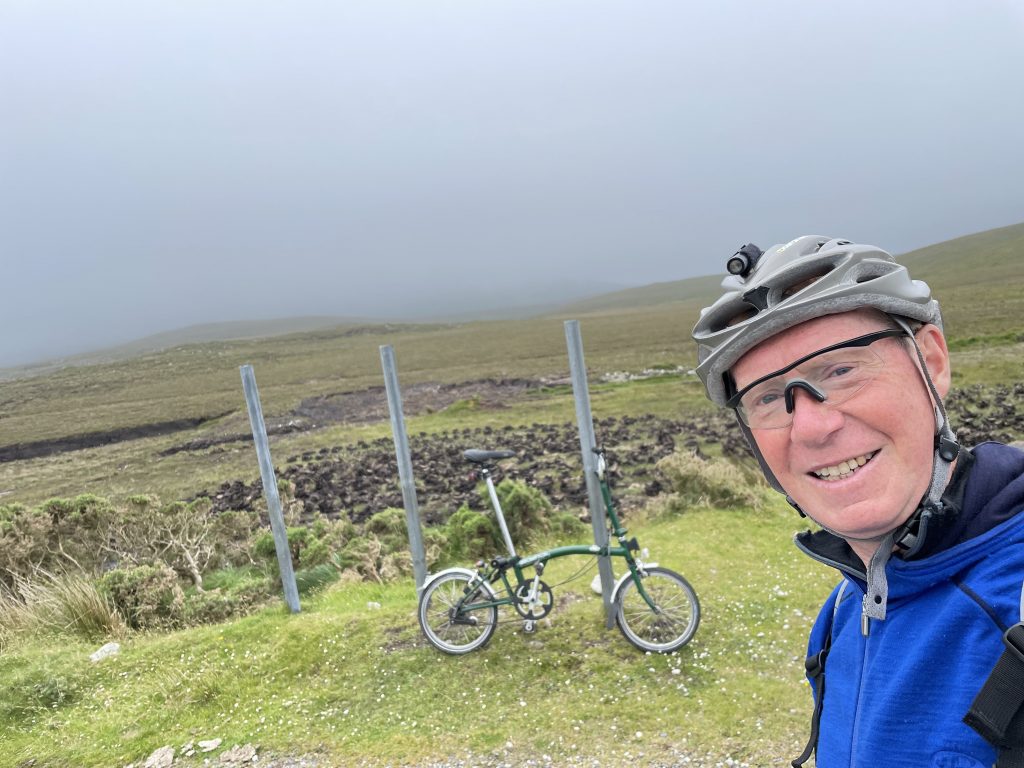
| At the top of the ascent of the road that goes over the An Mhaoilinn pass. There’s a side road from here that goes up even higher to the viewpoint at Barr an Mhionnain and if the weather had been better I might have been tempted to try the 320m / 1000ft ascent. But luckily for me, the clouds were right down so there would have been nothing to see for almost all of the ascent. Something for another day perhaps | |
Interactive map
(Elevations corrected at GPS Visualizer: Assign DEM elevation data to coordinates )
Max elevation: 83 m
Min elevation: -2 m
Total climbing: 890 m
Total descent: -892 m
Total time: 06:05:44
You can read earlier and later days’ blogs below
Previous day’s blog
Next day’s blog
Ireland home page
 Save as PDF