
Ireland day 0266. Tuesday 21 June 2022- Midsummer
| Today’s summary | Took Val to airport for her trip back to London then drove round to Lucan to explore the demesne and St Catherine’s Park. Went to Castletown and the Wonderful Barn (yes, really) in the afternoon to ensure full use was made of this midsummers day | ||||
| Today’s weather | Overcast but warm and dry all day. Hardly any wind. About 21C | ||||
 |
 |
||||
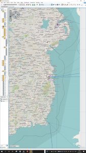
| Today’s overview location (The blue marks shows the location of my routes- roughly in the centre of the map) |
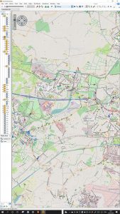
Close-up location (The grey lines shows where I walked) (Click buttons below to download GPX files of today’s walks as recorded, or see interactive maps at bottom with elevations corrected): Lucan Demesne and St Catherines Park Castletown woodlands and Celbridge |
||||
Commentary
A real blockbuster of a day, as befits the longest day of the year. Most of the technical detail is in the captions to the photos below, so take a look through. I actually found it quite interesting to read up about and write, so it might be a worthwhile use of a few minutes of your time.
We were up early as Val had to get to the airport for a mid-morning flight. She’s back in the UK for a couple of weeks, so I have been left to fend for myself while she’s away. So as soon as I was off the leash and Val was on the plane, I did what I am never allowed to do normally – and went to McDonalds. I know I am weak willed but it gets worse, trust me, as you will see if you read to the end. Anyway this morning all I wanted was a coffee so I could spend a few moments planning the rest of the day.
As I had hoped, over my coffee, a plan for the day emerged. First up, I wanted to visit Lucan – the next town up the Liffey from the Wren’s Nest weir that I’d walked to last week. There was an ulterior motive for wanting to visit, actually. A long-standing college friend is staying in Lucan on Friday and I wanted to check out a good place for us to eat. I’d also heard from a Walking Club friend that there was a good trail along the riverbank from Lucan Village, so I wanted to have a look at that as well.
Then, from Lucan I decided to go on to Castletown and Celbridge. We had visited Castletown House in late October last year, but I wanted to see what it was like on a nice warm day, and without the pressure of failing daylight. And now that I’m back in Malahide and looking back, I’m pleased to say that I think I pretty much succeeded in meeting both of the day’s objectives.
Lucan was interesting and bustling. Perhaps my most remarkable discovery was that the Italian Ambassador lives there – in a large house right in the middle of the village – known, appropriately enough as Lucan house. In fact Lucan house used to belong to Patrick Sarsfield, who was granted the title Lord Lucan by James II for his valour in the siege of Limerick, 1690.
Patrick’s successors were somewhat less illustrious. The third Lord Lucan was one of those who issued the infamous commands in Battle of Balaklava in 1854 which led to the ill-fated charge of the Light Brigade. He was also a notorious landlord during the Irish Famine, in 1845, evicting tenants and leading many to starve. And of course the seventh Lord Lucan was “the” Lord Lucan, who famously announced that he was going to lie doggo for a while, and then disappearing for ever, after (allegedly) murdering the family’s nanny in 1974.
But Lucan House hadn’t been in the Sarsfield family since 1925 and the seventh Lord Lucan never lived there. It was bought by the Italian Government in 1954 and has been the residence of the ambassador ever since. It’s apparently a fine 1560 Palladian villa, although it’s not visible from the road. It’s open to the public once a year, as part of the Lucan Festival.
Anyway just explaining about the house has taken three paragraphs and I haven’t really even started on the day’s main activities yet! So I better speed up a bit.
OK here we go. I headed west up the main road for a couple of hundred meters until I got to the Liffey Valley park (AKA Lucan Demesne) then scooted upstream alongside the river bank until I reached the bridge over to the north bank, and had a good look round St Catherine’s Park on the other side. Technically I think it’s part of Leixlip, the next town upstream. There’s a good riverside path on the north bank, but annoyingly it doesn’t quite run all the way back to Lucan. So you have to double back and exit via a housing estate – although there is a rather stunning carved monolithic statue of the warrior-king Cú Chulainn to admire as you make your way out.
Lucan explorations successfully completed, I drove a few miles further west to reach Castletown House. We had already visited this fine Palladian mansion, maintained by the OPW and therefore fabulous, back in October last year. So I don’t need to recount the history of Palladianism, which will cut out half a paragraph at least.
Today, rather than going into the house, I walked right through the estate and out the other side into nearby Celbridge. This is another attractive town, dominated by the stately home at one end and a large water mill at the other. I had a glance around the mill – it looks impressive from the outside but since it ceased operating as a factory, it has become a community centre which looks worthwhile but a bit under-funded. Celbridge is perhaps best known as the birthplace of Arthur Guinness, but, although there is a statue and a couple of interpretive plaques, I didn’t see a lot to commemorate the town’s most celebrated resident.
To the north of the Castletown house is a large area of woodland. It was apparently slated for housing development but was rescued by Desmond Guinness in the 1960s and is now open for public exploration. So I headed that way after checking out the Celbridge high street. It turned out to be a nice, quiet woodland area, which leads on to fields which overlook the back of Castletown house. There was nobody about and a good network of paths to walk through. It felt nice to be able to wander, albeit briefly, unconstrained by barbed wire and notices about prosecution.
I was soon back at the car but the day still wasn’t finished. Because next there was a late addition to the itinerary – prompted by one of the interpretive plaques in Celbridge. It was a short side-trip to a place called The Wonderful Barn (yes, it really is) and with a name like that, how can you possibly not want to visit? It’s a bit of a convoluted drive to get there – but it only takes 10 minutes from the House – and when you do arrive, it’s seriously weird.
You actually end up in a field in the middle of a large new housing estate. And before you is the Wonderful Barn itself. I really don’t know how to describe it as it is so surreal. It looks like something from a Disney theme-park, crossed with an oast house, and with a bit of windmill thrown in for good measure. You’ll just have to look at the picture at the bottom to see what I mean. It’s part folly, part serious, and it played an important role in averting famine in the 1750s. Take a look below to learn a bit more about this marvellous but crumbling ruin.
Now here’s the sting in the tail. When I went to McDonalds this morning, I got a voucher that would entitle me to a Big Mac and chips for €3.90. I thought this was too good an offer to miss, so weak-willed as I am, I headed once more for the golden arches – this time at Swords, and enjoyed my second dose of junk food in the day. Actually I really liked it and it was quite nice not to have any preparation or washing up to do. And for the money, I don’t think I could have made anything much cheaper.
Phew. I’m going to stop now. It’s been pretty non-stop for the last sixteen hours so I’m feeling a bit tired but satisfied that I have got the most out of the longest day. I’m quite looking forward to the nights drawing in, actually, as perhaps I won’t have to work quite so hard.
See you tomorrow!
Today’s photos (click to enlarge)
 |
 |
| Whoever would have thought it. The Italian ambassador to Ireland lives in the middle of Lucan Village. Peering through the gates, it looks very nice. But private. | In the Lucan Demesne. It’s on the banks of the Liffey, to the west of Lucan. If you walk to the very western edge of the grounds, you reach a water-pipe bridge which you can cross to get into St Catherine’s park on the other side. |
 |
 |
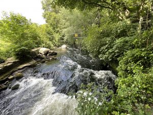
| St Catherine’s Park runs down the opposite (North) side of the Liffey, from Leixlip in the west towards Lucan in the east. There’s a nice woodland walk which takes you right down to the “rapids” in the river, where a semi-permanent canoe slalom course has been laid out | The back of Castletown house. “The finest Palladian mansion in Ireland”. We last visited on 29 October so see the blog from that date for more of the background. But this view is taken from the rear of the building, which we didn’t see last time. |
 |
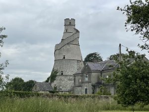 |
| The Mill in Celbridge. There’s been a mill here since at least the 13th century, processing, variously, corn, flax and wool. Its last incarnation was as a carpet factory, which finally closed in 1982. Now it’s a community centre and gymnasium | This place is as weird as it looks. Possibly the oddest place I have visited in Ireland, in fact. It’s the Wonderful Barn. Not a theme-park ride, but actually a thing of purpose. It’s just down the road from Castletown House and was built in 1743 by Katherine Conolly – the widow of William Conolly, the Speaker of the Irish House of Commons and first owner of Castletown House. She built it in response to the famine of 1740-41, which was caused by a winter of extreme cold which in turn froze the rivers and prevented delivery of grain to the mills for producing flour. The Wonderful Barn has five secure vaulted chambers for storing grain, so that sufficient could be stockpiled to supply the local community in the event of another freeze. It’s not completely clear why it has such an odd design but it was part-folly as well as serving an important purpose. Katherine deliberately over-designed it to provide extra work for impoverished labourers. Today, it’s in a state of semi-dereliction and fenced off with barbed wire. A real shame, as it’s such a fascinating place |
 |
|
| Standing guard over the entrance to St Catherine’s Park, and monolithically carved from a single treetrunk, is Cú Chulainn. He’s a mythical warrior-king demigod, depicted in the Ulster Cycle legends, possibly dating back to the Iron Age (500BC-400AD). He was born with the name Setanta but became Cú Chulainn, or “Hound of Culann”, after he single-handedly killed blacksmith Culann‘ s fearsome watchdog in a act of self defence, and offered to act as Culann’s guard as an act of atonement. It’s said that he used a hurley (hurling stick) and sliotar (leather-covered hurling ball) to kill the dog – which is testament to both the antiquity and hazardousness of the game. He was trained by the legendary female warrior Scáthach, who prophesied that he would fight many heroic battles but die young. He did indeed fight many battles, including a single-handed defence of Ulster. But he died young, in battle, as prophesied. In modern times, Cú Chulainn has become an Irish nationalist icon |
|
Interactive map 1 (Lucan)
(Elevations corrected at GPS Visualizer: Assign DEM elevation data to coordinates )
Max elevation: 51 m
Min elevation: 18 m
Total climbing: 196 m
Total descent: -196 m
Total time: 02:22:03
Interactive map 2 (Castletown)
(Elevations corrected at GPS Visualizer: Assign DEM elevation data to coordinates )
Max elevation: 73 m
Min elevation: 48 m
Total climbing: 102 m
Total descent: -103 m
Total time: 02:47:59
You can read earlier and later days’ blogs below
Previous day’s blog
Next day’s blog
Ireland home page
 Save as PDF