Ireland day 1480. Friday 17 October 2025- Dingle Day 6
| Today’s summary | A slow morning but then got going and walked right from the front door of our cottage on a 14km circular hike to An Sáis (=The Trap) aka Sauce Creek Bay. Then on along the clifftops to Brandon Point. Back via Brandon Village and drinks in Murphys Bar watching dive-bombing gannets. Finished off the walk to the cottage for cups of tea then walked back over the fields and footbridge to Murphys for dinner | ||||
| Today’s weather | Overcast but bright with some breaks in the cloud to let the sun through. Brandon summits visible. Moderate south easterly wind. Appx 14c | ||||
 |
 |
||||
| Today’s overview location (The blue mark shows the location of our route) |
Close-up location (The blue line shows where we walked) (Click button below to download GPX of today’s walk as recorded, or see interactive map at bottom with elevations corrected): Sioloid an tSais Sauce Creek Walk |
||||
Commentary
Every day since we arrived in Dingle almost a week ago, we have got in the cars and driven off somewhere. But today was different. We had a perfect full Irish cooked breakfast (prepared by Val) in the cottage and then rather than driving anywhere, we set off on a circular walk directly from our front door.
There is a popular hiking trail which happens to go pretty much past our cottage, looping up into the hills around Brandon Point. There’s a deep cleft in the Brandon sea-cliffs, known as An Sáis, meaning “The Trap” – so called because of the flotsam and jetsam which from time to time gets caught in its deep embrace. The Irish “Sáis” is pronounced “Sauce” – hence the anglicised version of the name of our walk today – the Sauce Creek Loop Trail.
It turned out to be a good choice. A really interesting route. And although the start and finish of the walk are on tarmac, the big stretch in the middle is on an upland terrain through the heather, which is narrow but well waymarked. Along the way, close to the start, we met an interesting footpath ranger, who quizzed us on our experiences of the various hikes we’d done in Kerry. A fascinating conversation.
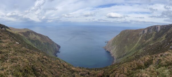
Once we reached the top of the hill, precipitous views down the cliffs on the coastal side opened up, with the magnificent An Sáis bay right below us. It looked pretty inhospitable and inaccessible, 300m down there, but apparently at one time there was a smallholding near the shore and we could indeed see some remains of field boundaries close to the beach. We paused to admire the magnificent view – and it felt particularly good to have it all to ourselves. We saw nobody else out on the path all day, apart from the ranger, despite the walk supposedly being “popular”.
A little way further on, there was a dip in the heather with a fine view out over the Atlantic, so we sheltered out of the wind there and had some coffee from the trusty Thermos, with a couple of chocolate biscuits. What more could you need? Refreshments, a view, and good company. But despite the shelter, there was a strong breeze blowing, so we soon started to cool down and didn’t linger long before our backpacks were re-packed and we were up and on our way again.
(A passing note about the weather: Most of our stay in Dingle has been remarkably wind-free, so today was the first time that what are perhaps more normal autumnal conditions had put in an appearance. But it was still dry and a week without rain in Dingle is pretty rare, so we’ve been very lucky)
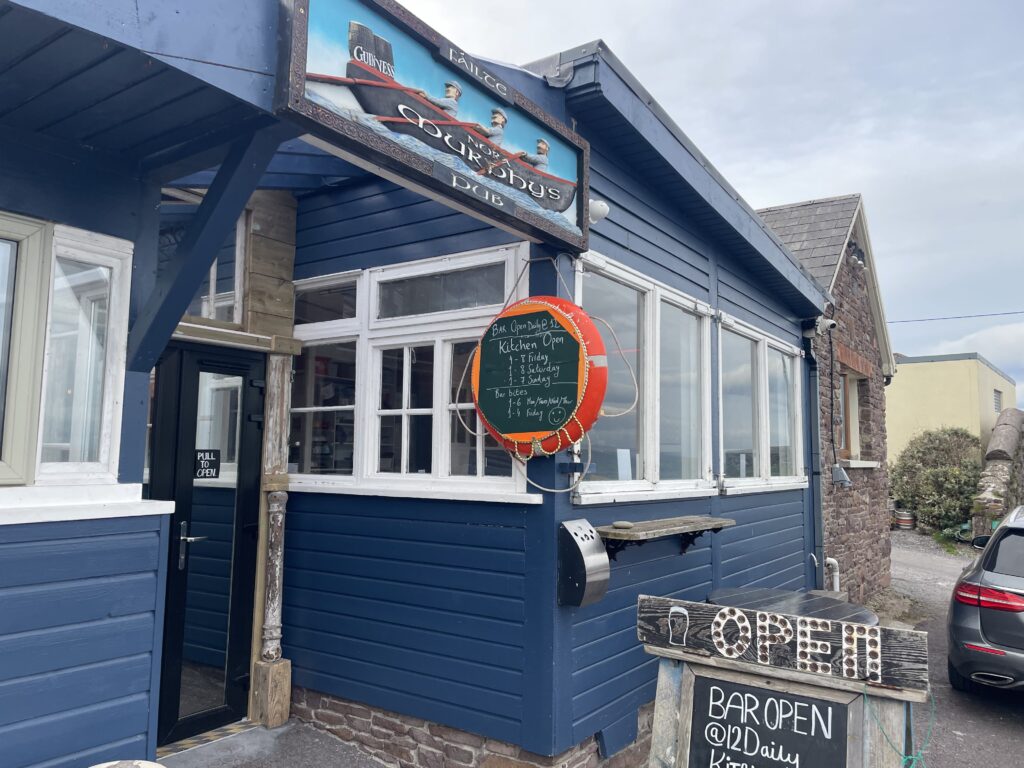
It turned out to be quite a long walk, and our lunch spot wasn’t even half way round – although it was the highest point of the loop. So we pottered along, following the waymarks, and eventually reached the road at Brandon Point. It’s an easy walk back from there to our cottage, but we made it a bit more interesting by stopping off in Murphy’s Bar in Brandon village to get some late-walk refreshments. It’s a lovely pub, right by the harbour, and we had a perfect view of the black-wingtipped gannets, plummeting vertically into the sea like guided missiles, hoping to snare an unsuspecting fish or two lunch. It was a spectacular sight.
From the pub, we walked down to the river estuary and crossed it, into the neighbouring fields, by way of the footbridge across the mudflats. It saved a longer and more hazardous walk along the road, which goes further inland. From the bridge we were soon back at the cottage, where we made ourselves teas and coffees. Then after putting our feet up for an hour or so, we left the cottage again and walked back to Murphy’s for a rather nice end-of-holiday celebratory meal. All in all, for us it was a highly recommended hostelry.
The final walk of the day, back over the bridge and through the field to our cottage, was pitch black. Luckily we always travel with head-torches (although it has to be said I never seem to need mine, so until today I was beginning to wonder why I bothered) so we could shine a light on our path through the darkness and on to the welcome beacon of our cottage.
That, and a couple of cups of tea, just about rounded off our day. A fabulous walk, amazing views and that most precious commodity of all: peace and quiet.
Today’s photos (click to enlarge)
 |
 |
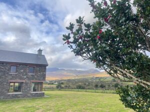
| The view of the Brandon range from the garden of our cottage. There are abundant holly berries everywhere – a harbinger of a cold winter to come, perhaps? | Everything you could ever possibly want to know about our route today (Note we modified it slightly at the bottom right hand side so it started and finished at our cottage) |
 |
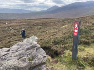 |
| Sturdy hiker on the path up the hill to the top of the cliffs | Approaching the top, with the cliffs and Sáis bay out of sight behind me (not to close!). The route was well signed with prominent red waymarks |
 |
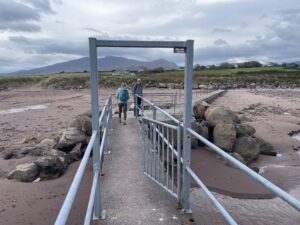 |
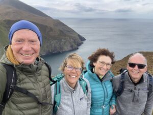
| The team of hardy hikers on the cliff top, with the bay behind | There’s a small bridge across the river that separates Brandon village from our cottage. It saves a more lengthy road-walk |
 |
|
| Murphy’s. So good we visited twice! Once on the way back from our walk, then again later in the evening for dinner. Head torches were required for the walk back across the bridge and through the fields. | |
Interactive map
(Elevations corrected at GPS Visualizer: Assign DEM elevation data to coordinates )
Max elevation: 402 m
Min elevation: 3 m
Total climbing: 571 m
Total descent: -571 m
Total time: 05:25:54
You can read earlier and later days’ blogs below
Previous day’s blog
Next day’s blog
Ireland home page
 Save as PDF