Where I’ll be, and when
See where I’m going to be, when
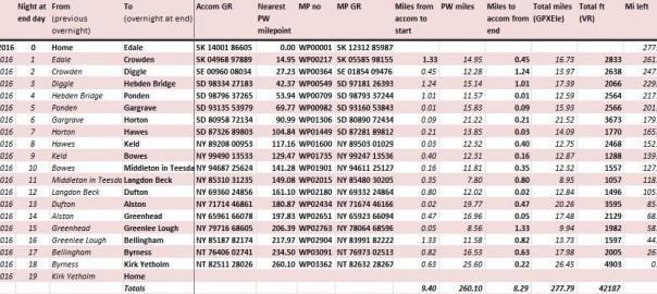
You can check out my whereabouts from the table below.
You can see the various locations on a map at the bottom of the page
| Walking day | From | To | Mi | Ft | |
| Su, 21 Feb 2016 | 00 | Home | Edale | ||
| Mo, 22 Feb 2016 | 01 | Edale | Crowden | 16.73 | 2833 |
| Tu, 23 Feb 2016 | 02 | Crowden | Diggle | 13.97 | 2638 |
| We, 24 Feb 2016 | 03 | Diggle | Hebden Bridge | 17.39 | 2066 |
| Th, 25 Feb 2016 | 04 | Hebden Bridge | Ponden | 12.59 | 2564 |
| Fr, 26 Feb 2016 | 05 | Ponden | Gargrave | 15.93 | 2566 |
| Sa, 27 Feb 2016 | 06 | Gargrave | Horton | 21.52 | 3673 |
| Su, 28 Feb 2016 | 07 | Horton | Hawes | 14.09 | 1770 |
| Mo, 29 Feb 2016 | 08 | Hawes | Keld | 12.75 | 2468 |
| Tu, 01 Mar 2016 | 09 | Keld | Bowes | 12.87 | 1288 |
| We, 02 Mar 2016 | 10 | Bowes | M’ton in T. | 12.32 | 1557 |
| Th, 03 Mar 2016 | 11 | M’ton in T. | Langdon Beck | 8.95 | 1057 |
| Fr, 04 Mar 2016 | 12 | Langdon Beck | Dufton | 12.84 | 1496 |
| Sa, 05 Mar 2016 | 13 | Dufton | Alston | 20.26 | 3595 |
| Su, 06 Mar 2016 | 14 | Alston | Greenhead | 17.48 | 2129 |
| Mo, 07 Mar 2016 | 15 | Greenhead | Greenlee L. | 9.94 | 1982 |
| Tu, 08 Mar 2016 | 16 | Greenlee L. | Bellingham | 13.73 | 1597 |
| We, 09 Mar 2016 | 17 | Bellingham | Byrness | 17.98 | 2005 |
| Th, 10 Mar 2016 | 18 | Byrness | Kirk Yetholm | 26.45 | 4903 |
| Fr, 11 Mar 2016 | 19 | Kirk Yetholm | Home | ||
| Whole route | Totals | 277. 79 |
42, 187 |
The map shows, geographically, where these places are located
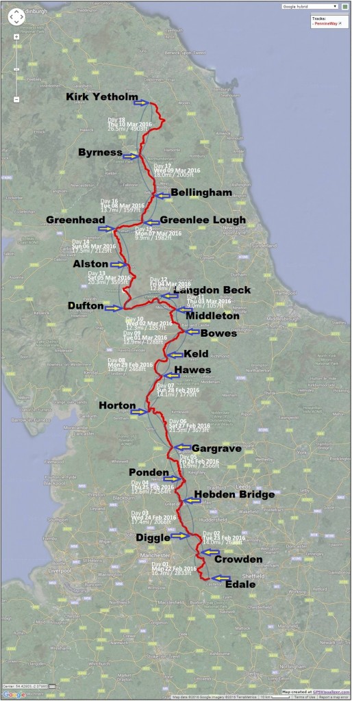
Below here, you can find an interactive map of the route – scroll mouse to zoom in or out
(NB: The route in this map runs from north to south – I will be doing it the other way round)
Total distance: 410932 m
Max elevation: 891 m
Min elevation: 109 m
Total climbing: 11315 m
Total descent: -11164 m
Download file: wrong way PW.gpx
Max elevation: 891 m
Min elevation: 109 m
Total climbing: 11315 m
Total descent: -11164 m
 Save as PDF